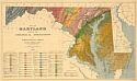
Viewing Options
Main Author:
Clark, William Bullock
Title/Description:
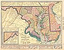
Map of Maryland showing the Geological Formations and Agricultural Soils
Publication Info:
Baltimore: A. Hoen and Company, [1906]

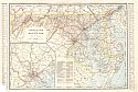
Viewing Options
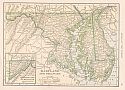
Main Author:
Rand McNally and Company
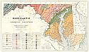
Title/Description:
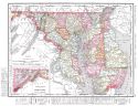
Maryland and Delaware
Publication Info:
Chicago: Rand McNally and Company, 1906; from the Business Atlas and Shippers Guide

Viewing Options
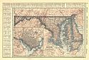
Main Author:
C.S. Hammond and Company
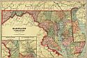
Title/Description:
Maryland and Delaware
Publication Info:
New York: C.S. Hammond and Company, 1906; from the Pictorial Atlas of the World
Viewing Options
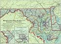
Main Author:
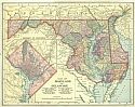
Cram, George F.
Title/Description:
Maryland and Delaware
Publication Info:
Chicago: George F. Cram for A. A. Grant, Toronto, Ont., 1906; from Grant's Bankers and Brokers Railroad System Atlas

Viewing Options
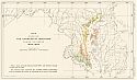
Main Author:
Maryland Geological Survey
Title/Description:
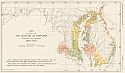
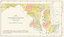
Map showing the Counties of Maryland during the period 1637-1650
Publication Info:
Baltimore: Maryland Geological Survey, 1906; Volume 6, Plate 36
Viewing Options
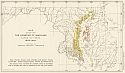
Main Author:
Maryland Geological Survey
Title/Description:
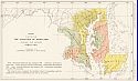
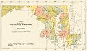
Map showing the Counties of Maryland during the period 1650-1654
Publication Info:
Baltimore: Maryland Geological Survey, 1906; Volume 6, Plate 37
Viewing Options
Main Author:
Maryland Geological Survey
Title/Description:
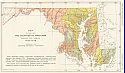
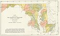
Map showing the Counties of Maryland during the period 1654-1657
Publication Info:
Baltimore: Maryland Geological Survey, 1906; Volume 6, Plate 38

Viewing Options
Main Author:
Maryland Geological Survey
Title/Description:
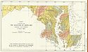
Map Showing the Counties of Maryland during the period 1657-1660
Publication Info:
Baltimore: Maryland Geological Survey, 1906; Volume 6, Plate 39
Viewing Options
Main Author:
Maryland Geological Survey
Title/Description:
Map showing the Counties of Maryland during the period 1660-1670
Publication Info:
Baltimore: Maryland Geological Survey, 1906; Volume 6, Plate 40

Viewing Options
Main Author:
Maryland Geological Survey
Title/Description:
Map showing the Counties of Maryland during the period 1670-1680
Publication Info:
Baltimore: Maryland Geological Survey, 1906; Volume 6, Plate 41
Viewing Options
Main Author:
Maryland Geological Survey
Title/Description:
Map showing the Counties of Maryland during the period 1680-1700
Publication Info:
Baltimore: Maryland Geological Survey, 1906; Volume 6, Plate 42

Viewing Options
Main Author:
Maryland Geological Survey
Title/Description:
Map showing the Counties of Maryland during the period 1700-1740
Publication Info:
Baltimore: Maryland Geological Survey, 1906; Volume 6, Plate 43
Viewing Options
Main Author:
Maryland Geological Survey
Title/Description:
Map showing the Counties of Maryland during the period 1740-1773
Publication Info:
Baltimore: Maryland Geological Survey, 1906; Volume 6, Plate 44

Viewing Options
Main Author:
Maryland Geological Survey
Title/Description:
Map Showing the Counties of Maryland during the period 1773-1776
Publication Info:
Baltimore: Maryland Geological Survey, 1906; Volume 6, Plate 45
Viewing Options
Main Author:
Maryland Geological Survey
Title/Description:
Map showing the Counties of Maryland during the period 1776-1789
Publication Info:
Baltimore: Maryland Geological Survey, 1906; Volume 6, Plate 46
Viewing Options
Main Author:
Maryland Geological Survey
Title/Description:
Map showing the Counties of Maryland during the period 1789-1836
Publication Info:
Baltimore: Maryland Geological Survey, 1906; Volume 6, Plate 47

Viewing Options
Main Author:
Maryland Geological Survey
Title/Description:
Map showing the Counties of Maryland during the period 1836-1850
Publication Info:
Baltimore: Maryland Geological Survey, 1906; Volume 6, Plate 48

Viewing Options
Main Author:
Maryland Geological Survey
Title/Description:
Map showing the Counties of Maryland during the period 1850-1867
Publication Info:
Baltimore: Maryland Geological Survey, 1906; Volume 6, Plate 49
Viewing Options
Main Author:
Maryland Geological Survey
Title/Description:
Map showing the Counties of Maryland during the period 1867-1872
Publication Info:
Baltimore: Maryland Geological Survey, 1906; Volume 6, Plate 50
Viewing Options
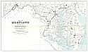
Main Author:
Rand McNally and Company
Title/Description:
Maryland and Delaware
Publication Info:
Chicago: Rand McNally and Company, 1906; from The World and its Peoples
Viewing Options
Main Author:
Maryland Geological Survey
Title/Description:
Map showing the Counties of Maryland during the period 1872-1907
Publication Info:
Baltimore: Maryland Geological Survey, 1906; Volume 6, Plate 51
Viewing Options
Main Author:
Hammond, C.S.
Title/Description:
Maryland and Delaware
Publication Info:
New York: C.S. Hammond, 1907; from his Modern Atlas of the World
Viewing Options
Main Author:
Maryland Geological Survey
Title/Description:
Map of Maryland Showing the Geological Formations and Agricultural Soils
Publication Info:
Baltimore: Maryland Geological Survey, 1907
Viewing Options
Main Author:
Cram, George F.
Title/Description:
Maryland and Delaware
Publication Info:
Chicago: George F. Cram, 1907; from Cram's Standard American Atlas

Viewing Options
Main Author:
P.F. Collier and Son
Title/Description:
Maryland and Delaware
Publication Info:
New York: P.F. Collier and Son, 1907; from The New Encyclopedic Atlas and Gazetteer of the World
Viewing Options
Main Author:
Mast, Crowell and Kirkpatrick
Title/Description:
Maryland and Delaware
Publication Info:
New York: The Crowell Publishing Co., 1908; from the Peerless Atlas of the World
Viewing Options
Main Author:
Hammond, C.S.
Title/Description:
Maryland and Delaware
Publication Info:
New York: C.S. Hammond & Co. 1908; from Hammond's Handy Atlas of the World

Viewing Options
Main Author:
Rand McNally and Company
Title/Description:
Maryland and Delaware
Publication Info:
Chicago: Rand McNally and Company, 1908; from The New Ideal State and County Survey and Atlas
Viewing Options
Main Author:
Patten, William and J.E. Homas
Title/Description:
Maryland, Delaware and the District of Columbia
Publication Info:
New York: P.F. Collier and Son, 1909; from The New Encyclopedic Atlas and Gazetteer of the World
Viewing Options
Main Author:
Cram, George F.
Title/Description:
Maryland, Delaware and the District of Columbia
Publication Info:
Chicago: George F. Cram, c.1909; from the Heart of our Country

Viewing Options
Main Author:
Maryland Geological Survey
Title/Description:
Map of Maryland showing Furnace Locations
Publication Info:
Baltimore: Maryland Geological Survey, 1909; Volume 9, Plate 7

Viewing Options
Main Author:
Maryland Geological Survey
Title/Description:
Map of Maryland showing distribution of Iron Ore
Publication Info:
Baltimore: Maryland Geological Survey, 1909; Volume 9, Plate 12
Viewing Options
Main Author:
Maryland Geological Survey
Title/Description:
Map of Maryland Showing the Highways Built by the Maryland Geological Survey
Publication Info:
Baltimore: Maryland Geological Survey, 1910

Viewing Options
Main Author:
Rand McNally and Company
Title/Description:
Maryland and Delaware
Publication Info:
Chicago: Rand McNally and Company, 1910; from New Ideal State and County Survey

Viewing Options
Main Author:
Maryland Geological Survey
Title/Description:
Map of Baltimore County and Baltimore City Showing the Topography and Election Districts
Publication Info:
Baltimore: Maryland Geological Survey, 1910