Viewing Options
Viewing Options
Viewing Options
Viewing Options
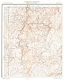
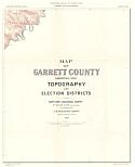
Main Author:
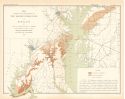
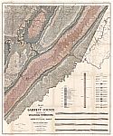
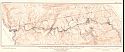
Maryland Geological Survey
Title/Description:
Map of Garrett County Showing the Topography and Election Districts
Publication Info:
Baltimore: Maryland Geological Survey, 1901; from Physical Atlas of Maryland
Viewing Options
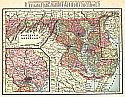
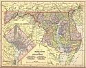
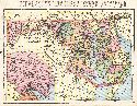
Main Author:
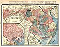
Cram, George F.
Title/Description:
Maryland and Delaware
Publication Info:
Chicago: The Fort Dearborn Publishing Co., 1901; from The National Standard Family and Business Atlas of the World
Viewing Options
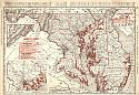
Main Author:
Rand McNally and Company
Title/Description:
Maryland, D.C., and Delaware
Publication Info:
Chicago: Rand McNally and Co., 1901; from Enlarged Business and Shippers Guide
Viewing Options
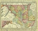
Main Author:
Rand McNally and Co.
Title/Description:
Maryland
Publication Info:
Chicago: Rand McNally and Co., 1901; from the Universal Atlas of the World
Viewing Options
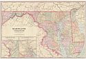
Main Author:
Cram, George F.
Title/Description:
Maryland and Delaware
Publication Info:
Chicago: George F. Cram, 1901; from Cram's Atlas of the World Ancient and Modern
Viewing Options
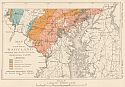
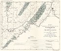
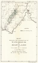
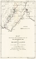
Main Author:
Clark, William B. and George C. Martin
Title/Description:
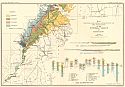
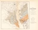
Map Showing the Distribution of the Eocene Formations of Maryland
Publication Info:
Baltimore: Maryland Geological Survey, 1901
Viewing Options
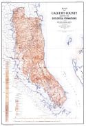
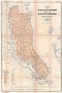
Main Author:
Clark, William Bullock
Title/Description:
Map of Calvert County Showing the Geological Formations
Publication Info:
Baltimore: Maryland Geological Survey, 1902
Viewing Options
Main Author:
Mast, Crowell and Kirkpatrick
Title/Description:
Map of Maryland and Delaware
Publication Info:
New York: Mast, Crowell and Kirkpatrick, [1902] from their Peerless Atlas
Viewing Options
Main Author:
Cram, George F.
Title/Description:
Maryland and Delaware
Publication Info:
Chicago: George F. Cram, 1902; from Cram's Railway System Atlas
Viewing Options
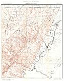
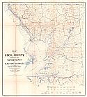
Main Author:
Maryland Geological Survey
Title/Description:
Map of Cecil County Showing the Topography and Election Districts
Publication Info:
Baltimore: Maryland Geological Survey, 1902
Viewing Options
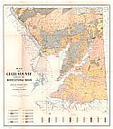
Main Author:
Maryland Geological Survey
Title/Description:
Map of Cecil County Showing the Agricultural Soils
Publication Info:
Baltimore: Maryland Geological Survey, 1902
Viewing Options
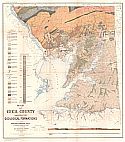
Main Author:
Maryland Geological Survey
Title/Description:
Map of Cecil County Showing the Geological Formations
Publication Info:
Baltimore: Maryland Geological Survey, 1902
Viewing Options
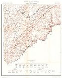
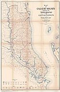
Main Author:
Maryland Geological Survey
Title/Description:
Map of Calvert County Showing the Topography and Election Districts
Publication Info:
Baltimore: Maryland Geological Survey, 1902
Viewing Options
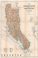
Main Author:
Maryland Geological Survey
Title/Description:
Map of Calvert County Showing the Agricultural Soils
Publication Info:
Baltimore: Maryland Geological Survey, 1902
Viewing Options
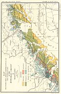
Main Author:
Maryland Geological Survey
Title/Description:
Map of Garrett County Showing the Geological Formations and Agricultural Soils
Publication Info:
Baltimore: Maryland Geological Survey, 1902

Viewing Options
Main Author:
The Century Company
Title/Description:
Maryland and Delaware
Publication Info:
Buffalo: The Matthew-Northrup Co., 1902; from The Century Atlas of the World
Viewing Options
Main Author:
Maryland Geological Survey
Title/Description:
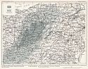
Map Showing the Distribution of the Coal Measures of Maryland
Publication Info:
Baltimore: Maryland Geological Survey, 1902; Volume 5, Plate 13
Viewing Options
Main Author:
Maryland Geological Survey
Title/Description:
Map Showing the Areal Distribution of the Formations of the Potomac Group in Maryland
Publication Info:
Baltimore: Maryland Geological Survey, 1902; Volume 4, Plate XXLXa
Viewing Options
Main Author:
Maryland Geological Survey
Title/Description:
Map Showing the Areal Distribution of the Formations of the Potomac Group in Maryland
Publication Info:
Baltimore: Maryland Geological Survey, 1902; Volume 4, Plate XXLXb
Viewing Options
Main Author:
Maryland Geological Survey
Title/Description:
Map of Central Cecil County showing Areal Distribution of Clay - Bearing Formations of the Potomac Group
Publication Info:
Baltimore: Maryland Geological Survey, 1902; Volume 4, Plate XLV
Viewing Options
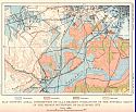
Main Author:
Maryland Geological Survey
Title/Description:
Map showing Areal Distribution of Clay - Bearing Formations of the Potomac Group in the Region Southwest of Baltimore City
Publication Info:
Baltimore: Maryland Geological Survey, 1902; Volume 4, Plate XLVII
Viewing Options
Main Author:
Maryland Geological Survey
Title/Description:
Map Showing the Distribution of the Mount Savage Fire Clay in Maryland
Publication Info:
Baltimore: Maryland Geological Survey, 1902; Volume 4, Plate LIV
Viewing Options
Main Author:
Maryland Geological Survey
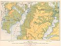
Title/Description:
Map of Central Maryland showing Rocks Yielding Residual Clays
Publication Info:
Baltimore: Maryland Geological Survey, 1902; Volume 4, Plate LVIII
Viewing Options
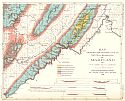
Main Author:
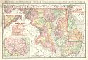
Maryland Geological Survey
Title/Description:
Map of Calvert County Showing the Geological Formations
Publication Info:
Baltimore: Maryland Geological Survey, 1903
Viewing Options
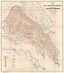
Main Author:
Maryland Geological Survey
Title/Description:
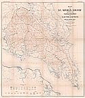
Map of St. Mary's County Showing the Geological Formations
Publication Info:
Baltimore: Maryland Geological Survey, 1903
Viewing Options
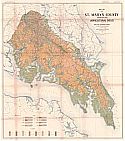
Main Author:
Maryland Geological Survey
Title/Description:
Map of St. Mary's County Showing the Agricultural Soils
Publication Info:
Baltimore: Maryland Geological Survey, 1903
Viewing Options
Main Author:
Maryland Geological Survey
Title/Description:
Map of St. Mary's County Showing the Topography and Election Districts
Publication Info:
Baltimore: Maryland Geological Survey, 1903
Viewing Options
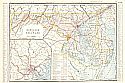
Main Author:
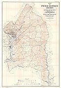
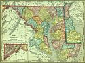
Maryland Geological Survey
Title/Description:
Map of Prince George's County and the District of Columbia Showing the Topography and Election Districts
Publication Info:
Baltimore: Maryland Geological Survey, 1903
Viewing Options
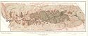
Main Author:
Maryland Geological Survey
Title/Description:
Map of the Georges Creek Coal Basin Showing the Location of mining properties and the areal extent of the Pittsburg (Big Vein) and Lower Coals
Publication Info:
Baltimore: Maryland Geological Survey, 1903; Volume 5, Plate 32
Viewing Options
Main Author:
Cram, George F.
Title/Description:
Maryland & Delaware
Publication Info:
Philadelphia: The Philadelphia Inquirer,1903; from Pictorial Atlas of the Greater United States and the World
Viewing Options
Main Author:
Miller, J. Martin
Title/Description:
Maryland and Delaware
Publication Info:
Unknown, 1904; from the Twentieth Century Atlas and Illustrated World

Viewing Options
Main Author:
Maryland Geological Survey
Title/Description:
Map showing the Distribution of the Lower Kittanning Coal of Maryland
Publication Info:
Baltimore: Maryland Geological Survey, 1904; Volume 5, Plate 24

Viewing Options
Main Author:
Maryland Geological Survey
Title/Description:
Map showing the Distribution of the Upper Freeport Coal of Maryland
Publication Info:
Baltimore: Maryland Geological Survey, 1904; Volume 5, Plate 26
Viewing Options
Main Author:
Maryland Geological Survey
Title/Description:
Map showing the Distribution of the Bakerstown Coal of Maryland
Publication Info:
Baltimore: Maryland Geological Survey, 1904; Volume 5, Plate 29
Viewing Options
Main Author:
Maryland Geological Survey
Title/Description:
Map showing the Distribution of the Upper Sewickley Coal of Maryland
Publication Info:
Baltimore: Maryland Geological Survey, 1904; Volume 5, Plate 34
Viewing Options
Main Author:
Maryland Geological Survey
Title/Description:
Map showing the Distribution of Waynesburg Coal of Maryland
Publication Info:
Baltimore: Maryland Geological Survey, 1904; Volume 5, Plate 35
Viewing Options
Main Author:
Shattuck, George Burbank
Title/Description:
Map Showing the Distribution of the Miocene Formations of Maryland
Publication Info:
Baltimore: Maryland Geological Survey, 1904
Viewing Options
Main Author:
Maryland Geological Survey
Title/Description:
Northern Appalachian Coal Field
Publication Info:
Baltimore: Maryland Geological Survey, 1905; Volume V, Plate XV
Viewing Options
Main Author:
Rand McNally and Company
Title/Description:
Maryland and Delaware
Publication Info:
Chicago: Rand McNally and Co., 1905; from Unrivaled Atlas of the World
Viewing Options
Main Author:
Rand McNally and Company
Title/Description:
Maryland and Delaware
Publication Info:
Chicago: Rand McNally and Company, 1905; from Enlarged Business Atlas and Shippers Guide
Viewing Options
Main Author:
Maryland Geological Survey
Title/Description:
Map of the Boundary Line between Allegany and Garrett Counties
Publication Info:
Baltimore: Maryland Geological Survey, 1905; Volume 5, Plate 7