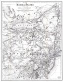
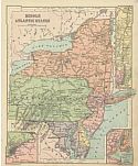
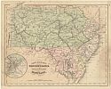
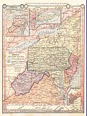
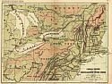
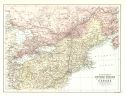
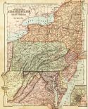
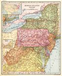
Viewing Options
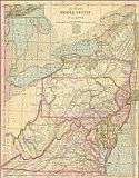
Main Author:
McNally, Francis
Title/Description:
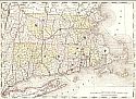
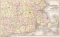
New Jersey, Pennsylvania, Delaware, and Maryland
Publication Info:
New York: A.S. Barnes and Company, 1876; from An Improved System of Geography
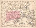
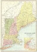
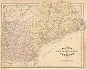
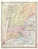
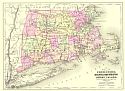
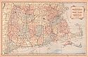
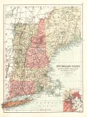
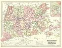
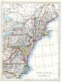
Viewing Options
Main Author:
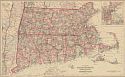
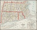
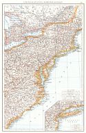
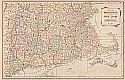
McNally, Francis
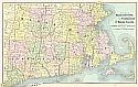
Title/Description:
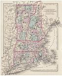
Massachusetts, Connecticut, and Rhode Island
Publication Info:
New York: A.S. Barnes and Company, 1876; from An Improved System of Geography
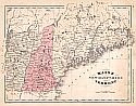
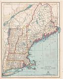
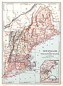
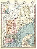
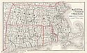
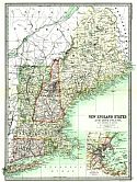
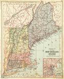
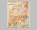
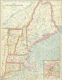
Viewing Options
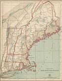
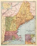
Main Author:
McNally, Francis
Title/Description:
Maine, New Hampshire, & Vermont
Publication Info:
New York: A.S. Barnes and Company, 1876; from An Improved System of Geography
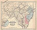
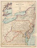
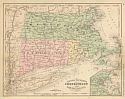
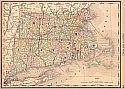
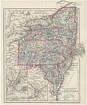
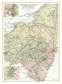
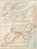
Viewing Options
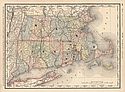
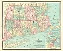
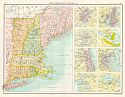
Main Author:
Gray, Ormando W.
Title/Description:
Gray's New Map of Massachusetts, Rhode Island and Connecticut
Publication Info:
Philadelphia: O.W. Gray and Son, 1876; from Gray's National Atlas with Descriptions
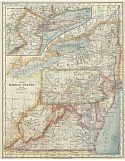
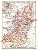
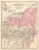
Viewing Options
Main Author:
von Steinwehr, A., D.G. Brinton
Title/Description:
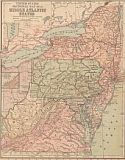
Middle States
Publication Info:
Cincinnati: Van Antwerp, Bragg and Company, 1877; from An Intermediate Geography with Lessons in Map Drawing
Viewing Options
Main Author:
Ellis and Patterson
Title/Description:
Map of a Portion of Maine, New Hampshire, and Massachusetts
Publication Info:
Manchester: Uncanoonuck Road Company, 1877; Made for the Uncanoonuck Road Co., Ellis and Patterson, C.E.'s
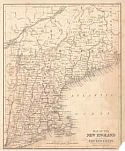
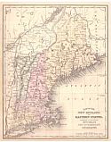
Viewing Options
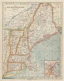
Main Author:
von Steinwehr, A., D.G. Brinton
Title/Description:
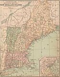
New England States
Publication Info:
Cincinnati: Van Antwerp, Bragg and Company, 1877; from An Intermediate Geography with Lessons in Map Drawing
Viewing Options
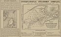
Main Author:
International Steamship Co.
Title/Description:
Map Showing the International Steamship Co.'s Route between Boston, Portland, Eastport, and St. John, N.B.
Publication Info:
Portland: International Steamship Co., 1878
Viewing Options
Main Author:
Black, Adam and Charles
Title/Description:
New York, Vermont, New Hampshire, Rhode Island, Massachusetts & Connecticut
Publication Info:
Edinburgh: A. & C. Black, 1879
Viewing Options
Main Author:
Gray, Frank A.
Title/Description:
Gray's New Map of Massachusetts, Rhode Island, and Connecticut
Publication Info:
Philadelphia: O.W. Gray & Son, 1880; from the National Atlas Containing Elaborate Topographical Maps of the United States and the Dominion of Canada with Plans of Cities and General Maps of the World
Viewing Options
Main Author:
Cram, George F.
Title/Description:
New Rain Road and County Map of the New England States
Publication Info:
Chicago: George F. Cram, c1880
Viewing Options
Main Author:
Swinton, William
Title/Description:
Middle Atlantic States
Publication Info:
New York: Ivison, Blakeman, Taylor and Company, 1881; from Swinton's Grammer School Geography
Viewing Options
Main Author:
von Steinwehr, A.
Title/Description:
Map of the Middle States
Publication Info:
Cincinnati: Von Antwerp, Bragg and Company, 1881; from Eclectic Series, School Geography No. 3
Viewing Options
Main Author:
Bartholomew, John
Title/Description:
New England States and Long Island with Environs of Boston
Publication Info:
Philadelphia: T. Ellwood Zell, 1881
Viewing Options
Main Author:
von Steinwehr, A.
Title/Description:
Map of the New England States
Publication Info:
Cincinnati: Von Antwerp, Bragg and Company, 1881; from Eclectic Series, School Geography No. 3
Viewing Options
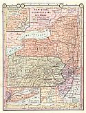
Main Author:
McNally, Francis
Title/Description:
New Jersey, Pennsylvania, Delaware and Maryland
Publication Info:
Chicago: A.S. Barnes and Company, 1882; from Rand McNally's System of Geography
Viewing Options
Main Author:
McNally, Francis
Title/Description:
Maine, New Hampshire and Vermont
Publication Info:
Chicago: A.S. Barnes and Company, 1882; from McNally's System of Geography
Viewing Options
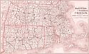
Main Author:
McNally, Francis
Title/Description:
Massachusetts, Connecticut and Rhode Island
Publication Info:
Chicago: A.S. Barnes and Company, 1882; from McNally's System of Geography
Viewing Options
Title/Description:
The Middle States
Publication Info:
Cincinnati: Von Antwerp, Bragg and Company, 1883; from The Eclectic Complete Geography
Viewing Options
Main Author:
Cram, George F.
Title/Description:
Massachusetts, Rhode Island and Connecticut
Publication Info:
Chicago: Henry S. Stebbins, 1883; from The Unrivaled Family Atlas of the World
Viewing Options
Title/Description:
New England
Publication Info:
Cincinnati: Von Antwerp, Bragg and Company, 1883; from The Eclectic Complete Geography
Viewing Options
Main Author:
Watson, Gaylord
Title/Description:
Massachusetts, Rhode Island and Connecticut
Publication Info:
Boston: Perry and Spaulding, 1883; from New Indexed Family Atlas of the United States with Maps of the World
Viewing Options
Main Author:
Ivison, Blakeman, Taylor and Company
Title/Description:
Middle Atlantic States
Publication Info:
New York: Ivison, Blakeman, Taylor and Company,1883; from Handy Atlas of the World
Viewing Options
Main Author:
Ivison, Blakeman, Taylor and Company
Title/Description:
New England and Eastern States
Publication Info:
New York: Ivison, Blakeman, Taylor and Company,1883; from Handy Atlas of the World
Viewing Options
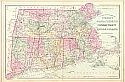
Main Author:
Mitchell, Samuel Augustus
Title/Description:
County and Township Map of the States of Massachusetts, Connecticut, and Rhode Island
Publication Info:
Philadelphia: S.A. Mitchell, 1884
Viewing Options
Main Author:
Gray, Frank A.
Title/Description:
Gray's New Map of Massachusetts, Rhode Island and Connecticut
Publication Info:
Philadelphia: O.W. Gray & Son, 1884
Viewing Options
Title/Description:
Map of New England or Eastern States
Publication Info:
Philadelphia: Cowperthwait and Company, 1884; from Warren's Common-School Geography
Viewing Options
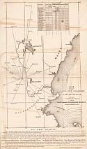
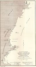
Main Author:
U.S. Army Corps of Engineers
Title/Description:
Map of the Coast between Boston and Portland showing localities and number of wrecks from 1874 to 1883 inclusive
Publication Info:
Washington: U.S. House of Representatives, 48th Congress, 2nd session, Doc. No. 56, 1884
Viewing Options
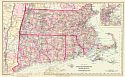
Main Author:
Watson, Gaylord
Title/Description:
Watson's Atlas Map of Massachusetts, Rhode Island, and Connecticut
Publication Info:
New York: Gaylord Watson, 1885; from Watson's New and Complete Illustrated Atlas of the World
Viewing Options
Main Author:
Tunison, Henry Cuthbert
Title/Description:
Massachusetts, Connecticut and Rhode Island
Publication Info:
Jacksonville, IL: H.C. Tunison, 1885
Viewing Options
Main Author:
Cram, George F.
Title/Description:
Massachusetts, Rhode Island and Connecticut
Publication Info:
Chicago: Henry S. Stebbins, 1885; from The Unrivaled Family Atlas of the World
Viewing Options
Main Author:
Monteith, James
Title/Description:
Middle Atlantic States
Publication Info:
New York: A.S. Barnes and Company, 1885; from Monteith's Independent Course Comprehensive Geography
Viewing Options
Main Author:
Monteith, James
Title/Description:
[New England]
Publication Info:
New York: A.S. Barnes and Company, 1885; from Monteith's Independent Course Comprehensive Geography
Viewing Options
Main Author:
Monteith, James
Title/Description:
New York, Pennsylvania, and New Jersey
Publication Info:
New York: A.S. Barnes and Company, 1886; from Barnes' Complete Geography
Viewing Options
Main Author:
Monteith, James
Title/Description:
New England States
Publication Info:
New York: A.S. Barnes and Company, 1886; from Barnes' Complete Geography
Viewing Options
Main Author:
Cram, George F.
Title/Description:
Atlas Map of Massachusetts, Connecticut, and Rhode Island
Publication Info:
Chicago: George F. Cram, 1887
Viewing Options
Main Author:
Cram, George F.
Title/Description:
Massachusetts, Rhode Island & Connecticut
Publication Info:
Chicago: George F. Cram, 1887
Viewing Options
Main Author:
The Peoples Publishing Company
Title/Description:
Atlas Map of Massachusetts, Connecticut and Rhode Island
Publication Info:
Chicago: The Peoples Publishing Company, 1887; from The Peoples' Unrivaled Family Atlas of the World
Viewing Options
Main Author:
Mitchell, S. Augustus
Title/Description:
Map of the Middle States
Publication Info:
Philadelphia: E.H. Butler and Company, 1888; from Mitchell's A System of Modern Geography
Viewing Options
Main Author:
Johnson, Alvin J.
Title/Description:
Map of Connecticut, Massachusetts and Rhode Island
Publication Info:
New York: Johnson and Ward, 1888; Drawn and Engraved on Copper-Plate Expressly for Johnson's Cyclopedia
Viewing Options
Main Author:
People's Publishing Co.
Title/Description:
Atlas Map of Massachusetts, Connecticut, and Rhode Island
Publication Info:
Rochester: W.H. Stewart & Co., 1888; from The Peoples' Illustrated & Descriptive Family Atlas of the World
Viewing Options
Main Author:
Rand McNally & Co.
Title/Description:
Massachusetts, Connecticut, and Rhode Island
Publication Info:
Chicago: Rand McNally & Co., 1888; from Rand McNally's Standard Atlas of the World
Viewing Options
Main Author:
Mitchell, S. Augustus
Title/Description:
Map of the New England or Eastern States
Publication Info:
Philadelphia: E.H. Butler and Company, 1888; from Mitchell's A System of Modern Geography
Viewing Options
Main Author:
Longmans, Green and Company
Title/Description:
Canada Proper and the North Eastern United States
Publication Info:
London: Longmans, Green and Co., 1889; from Longman's New Atlas, Political and Physical
Viewing Options
Main Author:
Mast, Crowell and Kirkpatrick
Title/Description:
Map of Massachusetts, Rhode Island and Connecticut
Publication Info:
Springfield, Ohio: Mast, Crowell and Kirkpatrick, 1889; from Peerless Atlas of the World
Viewing Options
Main Author:
Colton, J.H.
Title/Description:
United States, Section No. 3 (New York, Pennsylvania, New Jersey, Maryland and Delaware)
Publication Info:
New York: Sheldon and Company, 1890; from Colton's Common School Geography
Viewing Options
Main Author:
Bartholomew, John
Title/Description:
New England States
Publication Info:
London: MacMillan and Co., 1890; from The Library Reference Atlas of the World
Viewing Options
Main Author:
Alden, John B.
Title/Description:
(Massachusetts, Connecticut and Rhode Island)
Publication Info:
New York: John B. Alden, 1890
Viewing Options
Main Author:
Colton, J.H.
Title/Description:
United States, Section No. 2 (Vermont, New Hampshire, Massachusetts, Connecticut and Rhode Island)
Publication Info:
New York: Sheldon and Company, 1890; from Colton's Common School Geography
Viewing Options
Main Author:
Appleton, D.
Title/Description:
Middle Atlantic States
Publication Info:
New York: D. Appleton and Company, c. 1891; from Appleton's Standard Higher Geography
Viewing Options
Main Author:
Appleton, D.
Title/Description:
New England States
Publication Info:
New York: D. Appleton and Company, c. 1891; from Appleton's Standard Higher Geography

Viewing Options
Main Author:
Stieler, Adolf
Title/Description:
Die Atlantishen Staaten zwinchen Washington & Boston
Publication Info:
Gotha: Justus Perthes, 1891 from his Hand Atlas of 1891
Viewing Options
Main Author:
Bartholomew, J.
Title/Description:
Northern United States and Adjoining Provinces of Canada
Publication Info:
New York: Thomas Nelson and Sons, 1891; from The Popular Hand Atlas of the World
Viewing Options
Main Author:
Bartholomew, J.
Title/Description:
New England States and Long Island
Publication Info:
New York: Thomas Nelson and Sons, 1891; from The Popular Hand Atlas of the World
Viewing Options
Main Author:
Bartholomew, J.
Title/Description:
New York, New Jersey, Pennsylvania, Maryland and Delaware
Publication Info:
New York: Thomas Nelson and Sons, 1891; from The Popular Hand Atlas of the World
Viewing Options
Main Author:
Swinton, William
Title/Description:
Reference Map of the New England States
Publication Info:
New York: Ivison, Blakeman and Company, 1892; from A Complete Course in Geography
Viewing Options
Main Author:
Swinton, William
Title/Description:
Reference Map of the Middle Atlantic States and Part of West Virginia
Publication Info:
New York: Ivison, Blakeman and Company, 1892; from A Complete Course in Geography
Viewing Options
Main Author:
Fisk & Company
Title/Description:
Map of the Adirondack Mts. And Map of the White Mountains (New Hampshire)
Publication Info:
Chicago: Hunt & Eaton, 1892; from The Columbian Atlas of the World We Live In
Viewing Options
Main Author:
Fisk & Company
Title/Description:
Massachusetts, Connecticut and Rhode Island
Publication Info:
New York: Hunt & Eaton, c1892; from the Peoples' Cyclopedia
Viewing Options
Title/Description:
Middle Atlantic States, Northern Division
Publication Info:
New York: University Publishing Company, 1892; from Manual of Geography
Original Source:
Geological Survey of Alabama
Viewing Options
Main Author:
Gaskell, C.A.
Title/Description:
Atlas map of Massachusetts, Connecticut and Rhode Island
Publication Info:
Chicago: U.S. Publishing House, 1893; from The Family and Business Atlas of the World
Viewing Options
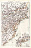
Title/Description:
United States, North-Eastern
Publication Info:
Edinburgh: Johnston, c.1895
Viewing Options
Main Author:
Bartholomew, John
Title/Description:
New England States
Publication Info:
Edinburgh: John Bartholomew & Co., c.1895; from the Citizen's Atlas
Viewing Options
Main Author:
Frye, Alexis Everett
Title/Description:
New England States
Publication Info:
Boston: Ginn and Company, 1896; from Frye's Complete Geography
Viewing Options
Main Author:
Frye, Alexis Everett
Title/Description:
Middle Atlantic States
Publication Info:
Boston: Ginn and Company, 1896; from Frye's Complete Geography
Viewing Options
Main Author:
American Book Company
Title/Description:
The Middle States
Publication Info:
New York: American Book Company, 1896; from The Eclectic Complete Geography
Viewing Options
Main Author:
American Book Company
Title/Description:
The New England States
Publication Info:
New York: American Book Company, 1896; from The Eclectic Complete Geography
Viewing Options
Main Author:
Johnston, William and Alexander Keith
Title/Description:
United States (N.E.)
Publication Info:
Edinburgh: W. and A.K. Johnston, 1897
Viewing Options
Main Author:
Mast, Crowell & Kirckpatrick
Title/Description:
Map of Massachusetts, Rhode Island, and Connecticut
Publication Info:
Philadelphia: Mast, Crowell, & Kirkpatrick, 1898; from The Peerless Atlas of the World
Viewing Options
Main Author:
The Times London
Title/Description:
United States, North-Eastern
Publication Info:
The Times London, 1899