
Viewing Options
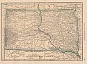
Main Author:
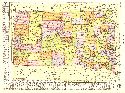
Rand McNally and Company
Title/Description:
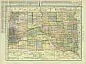
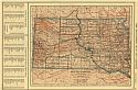
Rand McNally & Co.'s South Dakota
Publication Info:
Chicago: Rand McNally & Co., 1906
Viewing Options
Main Author:
C.S. Hammond and Company
Title/Description:
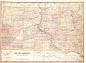
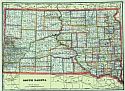
South Dakota
Publication Info:
New York: C.S. Hammond and Company, 1906; from The Pictorial Atlas of the World

Viewing Options
Main Author:
Cram, George F.
Title/Description:
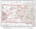
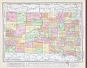
South Dakota
Publication Info:
Chicago: George F. Cram for A. A. Grant, Toronto, Ont., 1906; from Grant's Bankers and Brokers Railroad System Atlas
Viewing Options
Main Author:
Cram, George F.
Title/Description:
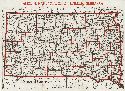
South Dakota
Publication Info:
Chicago: George F. Cram, 1906; from Cram's Superior Reference Atlas
Viewing Options
Main Author:
Rand McNally and Company
Title/Description:
South Dakota
Publication Info:
Chicago: Rand McNally and Company, 1906; from The World and its Peoples

Viewing Options
Main Author:
Cram, George F.
Title/Description:
South Dakota
Publication Info:
Chicago: George F. Cram, 1907; from Cram's Standard American Atlas

Viewing Options
Main Author:
P.F. Collier and Son
Title/Description:
South Dakota
Publication Info:
New York: P.F. Collier and Son, 1907; from The New Encyclopedic Atlas and Gazetteer of the World
Viewing Options
Main Author:
Peterson, E. Frank
Title/Description:
South Dakota
Publication Info:
Aberdeen: Searle Brothers, Printers, 1907
Original Source:
Murray Hudson
Viewing Options
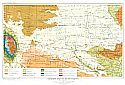
Main Author:
Darton, N.H.
Title/Description:
Geologic Map of South Dakota
Publication Info:
Washington: Department of the Interior, U.S. Geological Survey, 1908; from Water Supply Paper 227, Plate I

Viewing Options
Main Author:
U.S. Geological Survey
Title/Description:
Map Showing distribution of underground water in the Dakota and underlying sandstones in the northern half of the Black Hills Region in South Dakota and Wyoming
Publication Info:
Washington: Department of the Interior, U.S. Geological Survey

Viewing Options
Main Author:
U.S. Geological Survey
Title/Description:
Geologic Map of the Northern Half of the Black Hills Region in South Dakota and Wyoming
Publication Info:
Washington: Department of the Interior, U.S. Geological Survey

Viewing Options
Main Author:
U.S. Geological Survey
Title/Description:
Geologic Map of South Dakota
Publication Info:
Washington: Department of the Interior, U.S. Geological Survey, 1908; Water Supply Paper No. 227 Plate 1

Viewing Options
Main Author:
U.S. Geological Survey
Title/Description:
Map of South Dakota showing the Artesian Conditions
Publication Info:
Washington: Department of the Interior, U.S. Geological Survey, 1908; Water Supply Paper No. 227 Plate 11

Viewing Options
Main Author:
U.S. Geological Survey
Title/Description:
Map of South Dakota, Showing Structure of the Dakota Sandstone
Publication Info:
Washington: Department of the Interior, U.S. Geological Survey, 1908; Water Supply Paper No. 227 Plate 13
Viewing Options
Main Author:
Hammond, C.S.
Title/Description:
South Dakota
Publication Info:
New York: C.S. Hammond & Co. 1908; from Hammond's Handy Atlas of the World
Viewing Options
Main Author:
Perisho, Ellwood C.
Title/Description:
Map of South Dakota between the Missouri River and the Black Hills
Publication Info:
Vermillion: South Dakota Geological Survey, 1908; Bulletin No. 4
Viewing Options
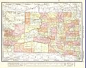
Main Author:
Rand McNally and Company
Title/Description:
South Dakota
Publication Info:
Chicago: Rand McNally and Company, 1908; from The New Ideal State and County Survey and Atlas
Viewing Options
Main Author:
Patten, William and J.E. Homas
Title/Description:
South Dakota
Publication Info:
New York: P.F. Collier and Son, 1909; from The New Encyclopedic Atlas and Gazetteer of the World
Viewing Options
Main Author:
Cram, George F.
Title/Description:
South Dakota
Publication Info:
Chicago: George F. Cram, c.1909; from The Heart of our Country

Viewing Options
Main Author:
Rand McNally and Company
Title/Description:
South Dakota
Publication Info:
Chicago: Rand McNally and Company, 1910; from The Enlarged Business Atlas and Shippers Guide
Viewing Options
Main Author:
Jeffries, Zay
Title/Description:
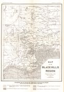
Map of the Black Hills Region
Publication Info:
Rapid City: South Dakota School of Mines, 1910; Bulletin No. 9
Viewing Options
Main Author:
Rand McNally and Company
Title/Description:
South Dakota
Publication Info:
Chicago: Rand McNally and Company, 1910; from New Ideal State and County Survey
Viewing Options
Main Author:
C.S. Hammond and Company
Title/Description:
South Dakota
Publication Info:
New York: C.S. Hammond and Company,1910; from The New Reference Atlas of the World

