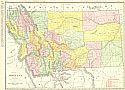
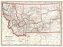
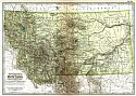
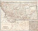
Viewing Options
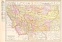
Main Author:
Rand McNally & Company
Title/Description:
Montana
Publication Info:
Chicago: Rand McNally & Co., 1911
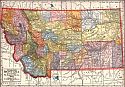
Viewing Options
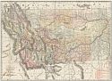
Main Author:
C.S. Hammond and Company
Title/Description:
Montana
Publication Info:
New York: C.S. Hammond and Company, 1911; from Hammond's Modern Atlas of the World
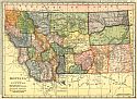
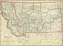
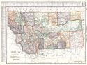
Viewing Options
Main Author:
Geographical Publishing Company
Title/Description:
Montana
Publication Info:
Chicago: The Geographical Publishing Company, 1911
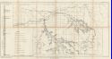
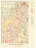
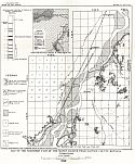
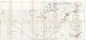
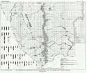
Viewing Options
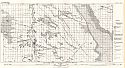
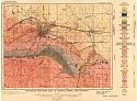
Main Author:
Lupton, C.T. and Henry Hinds
Title/Description:
Map of the Northeastern part of the Bull Mountain Coal Field, Montana
Publication Info:
Washington: Department of the Interior, U.S. Geological Survey, 1911; Bulletin 431
Viewing Options
Main Author:
Cram, George F.
Title/Description:
Montana
Publication Info:
Chicago: George F. Cram, 1911; from Cram's Unrivaled Atlas of the World
Viewing Options
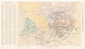
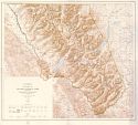
Main Author:
U.S. Geological Survey
Title/Description:
Administrative Map of Glacier National Park, Montana
Publication Info:
Washington: Department of the Interior, U.S. Geological Survey, 1911
Original Source:
Geological Survey of Alabama
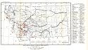
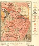
Viewing Options
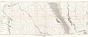
Main Author:
U.S. Geological Survey
Title/Description:
Map of Montana, Showing Location of Mining Districts
Publication Info:
Washington: Department of the Interior, U.S. Geological Survey, 1912; Bulletin 507 Plate VIII
Viewing Options
Main Author:
Rand McNally and Company
Title/Description:
Montana
Publication Info:
Chicago: Rand McNally and Company, 1912; from The Rand McNally's Imperial Atlas of the World
Viewing Options
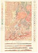
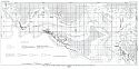
Main Author:
U.S. Geological Survey
Title/Description:
Geologic Map of the Region Surrounding the Butte District, Montana
Publication Info:
Washington: Deparment of the Interior, U.S. Geological Survey, 1912
Viewing Options
Main Author:
U.S. Geological Survey
Title/Description:
Geologic and Vein Map of Butte, Montana
Publication Info:
Washington: Deparment of the Interior, U.S. Geological Survey, 1912
Viewing Options
Main Author:
U.S. Geological Survey
Title/Description:
Geologic Map and Sections of the Philipsburg Quadrangle, Montana
Publication Info:
Washington: Deparment of the Interior, U.S. Geological Survey, 1912
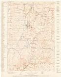
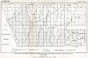
Viewing Options
Main Author:
U.S. Geological Survey
Title/Description:
Topographic Map of the Philipsburg Quadrangle, Montana Showing Location of Mines
Publication Info:
Washington: Deparment of the Interior, U.S. Geological Survey, 1912
Viewing Options
Main Author:
U.S. Geological Survey
Title/Description:
Map of the Baker Lignite Field, Custer County, Montana
Publication Info:
Washington: Department of the Interior, U.S. Geological Survey, 1912; Bulletin 471 Plate XV
Viewing Options
Main Author:
U.S. Geological Survey
Title/Description:
Map of the Terry Lignite Field, Custer County, Montana
Publication Info:
Washington: Department of the Interior, U.S. Geological Survey, 1912; Bulletin 471 Plate XVIII
Viewing Options
Main Author:
U.S. Geological Survey
Title/Description:
Map of the Glendrive Lignite Field, Custer and Dawson Counties, Montana
Publication Info:
Washington: Department of the Interior, U.S. Geological Survey, 1912; Bulletin 471 Plate XX
Viewing Options
Main Author:
U.S. Geological Survey
Title/Description:
Map of the Southern Part of Lignite Field, Dawson County, Montana
Publication Info:
Washington: Department of the Interior, U.S. Geological Survey, 1912; Bulletin 471 Plate XXIII
Viewing Options
Main Author:
U.S. Geological Survey
Title/Description:
Map of the Northern Part of the Sidney Lignite Field, Dawson County, Montana
Publication Info:
Washington: Department of the Interior, U.S. Geological Survey, 1912; Bulletin 471 Plate XXIV
Viewing Options
Main Author:
U.S. Geological Survey
Title/Description:
Detailed Map of the Southern Part of Culbertson Lignite Field, Valley County, Montana
Publication Info:
Washington: Department of the Interior, U.S. Geological Survey, 1912; Bulletin 471 Plate XXVI
Viewing Options
Main Author:
U.S. Geological Survey
Title/Description:
Map of the Southern Extension of the Milk River Coal Field, Chouteau County, Montana
Publication Info:
Washington: Department of the Interior, U.S. Geological Survey, 1912; Bulletin 471 Plate XXVIII
Viewing Options
Main Author:
U.S. Geological Survey
Title/Description:
Geologic Map of Livingston and Trail Creek Coal Fields, Park, Gallatin and Sweetgrass Counties, Montana
Publication Info:
Washington: Department of the Interior, U.S. Geological Survey, 1912; Bulletin 471 Plate XXIX
Viewing Options
Main Author:
The Century Company
Title/Description:
Montana
Publication Info:
New York: The Century Company, 1913; from The Century Atlas of the World
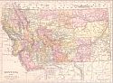
Viewing Options
Main Author:
Cram, George F.
Title/Description:
Montana
Publication Info:
Chicago: George F. Cram, 1913; from Cram's Unrivaled Atlas of the World
Viewing Options
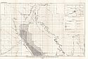
Main Author:
U.S. Geological Survey
Title/Description:
Map of the Little Sheep Mountain Coal Field, Dawson, Custer and Roseboud Counties Montana
Publication Info:
Washington: Department of the Interior, U.S. Geological Survey, 1913; Bulletin 513 Plate XIII
Viewing Options
Main Author:
U.S. Geological Survey
Title/Description:
Geologic Map of the Helena Mining Region
Publication Info:
Washington: Department of the Interior, U.S. Geological Survey, 1913; Bulletin 527 Plate I
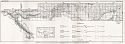
Viewing Options
Main Author:
U.S. Geological Survey
Title/Description:
Detailed Geologic Map of Helena, Mont., and Vicinity
Publication Info:
Washington: Department of the Interior, U.S. Geological Survey, 1913; Bulletin 527 Plate VII
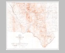
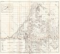
Viewing Options
Main Author:
U.S. Department of the Interior, U.S. Geological Survey
Title/Description:
Topographic Map of Glacier National Park, Montana
Publication Info:
Washington: U.S. Department of the Interior, U.S. Geological Survey, 1914
Viewing Options
Main Author:
Rand McNally & Company
Title/Description:
Rand McNally's New Map of Montana
Publication Info:
Chicago: Rand McNally & Co., 1914; from Rand McNally's Banker's Directory and List of Attorneys
Viewing Options
Main Author:
Rand McNally & Co.
Title/Description:
New Commercial Atlas Map of Montana
Publication Info:
Chicago: Rand McNally & Co., 1914
Viewing Options
Main Author:
Reynolds, Francis J.
Title/Description:
Montana
Publication Info:
New York: P.F. Collier and Son, 1914; from The New Encyclopedic Atlas and Gazetteer of the World
Viewing Options
Main Author:
C.S Hammond and Company
Title/Description:
Montana
Publication Info:
New York: C.S. Hammond and Company, 1914; from Hammond's Commercial and Library Atlas of the World
Viewing Options
Main Author:
U.S. Geological Survey
Title/Description:
Map Showing Coal Resources and Sections of the Coal Beds of Northern Teton County, Montana
Publication Info:
Washington: Department of the Interior, U.S. Geological Survey, 1915; Bulletin 621 Plate XVI

