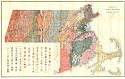
Viewing Options
Main Author:
U.S. Geological Survey
Title/Description:
Preliminary Map of Massachusetts and Rhode Island
Publication Info:
Washington: Department of the Interior, U.S. Geological Survey, 1916; Bulletin No. 597, Plate X
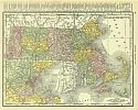
Viewing Options
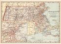
Main Author:
Rand McNally and Company
Title/Description:
Massachusetts
Publication Info:
Chicago: Rand McNally and Co., 1916; from the Ideal Atlas of the World
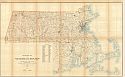
Viewing Options
Main Author:
U.S. Geological Survey
Title/Description:
Topographic Map of Massachusetts and Rhode Island showing principal drainage basins and locations of gaging stations
Publication Info:
Washington: Department of the Interior, U.S. Geological Survey, 1916; from Water Supply Paper No. 415 Plate 1
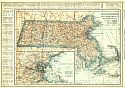
Viewing Options
Main Author:
Reynolds, Francis J.
Title/Description:
Massachusetts
Publication Info:
New York: P.F. Collier and Son Company, 1920; from The New World Atlas and Gazetteer
Viewing Options
Main Author:
Cram, George F.
Title/Description:
Massachusetts
Publication Info:
Chicago: George F. Cram, 1920; from Descriptive Review Showing Development of the State of Pennsylvania
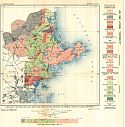
Viewing Options
Main Author:
U.S. Geological Survey
Title/Description:
Geologic Reconnaissance Map and Structure Section of Essex County, Massachusetts
Publication Info:
Washington: Department of the Interior, U.S. Geological Survey, 1920; Bulletin 704 Plate I
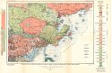
Viewing Options
Main Author:
U.S. Geological Survey
Title/Description:
Geologic Map and Structure Section of Parts of Essex, Suffolk and Middlesex Counties, Massachusetts
Publication Info:
Washington: Department of the Interior, U.S. Geological Survey, 1920; Bulletin 704 Plate II

