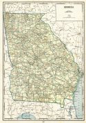
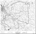
Viewing Options
Main Author:
U.S. Department of Commerce, Bureau of the Census
Title/Description:
Georgia Minor Civil Divisions - Militia Districts (1940 census)
Publication Info:
Washington: U.S. Government Printing Office, 1941

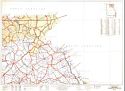
Viewing Options
Main Author:
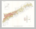
U.S. Coast and Geodetic Survey
Title/Description:
Savannah Sectional Aeronautical Chart
Publication Info:
Washington: U.S. Coast and Geodetic Survey, 1941
Viewing Options
Main Author:
Geographical Publishing Company
Title/Description:
Georgia
Publication Info:
Chicago: Geographical Publishing Company, 1942; from The New International Atlas of the World, War Edition

Viewing Options
Viewing Options
Viewing Options
Viewing Options
Viewing Options
Viewing Options
Viewing Options
Viewing Options
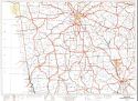
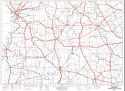
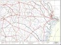
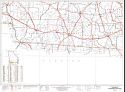
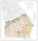
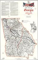
Main Author:
Federal Works Agency, Public Roads Administration
Title/Description:
Georgia Transportation Map
Publication Info:
Washington:1943
Viewing Options
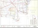
Main Author:
Army Map Service
Title/Description:
Fort Benning Reservation
Publication Info:
Washington: Army Map Service, U.S. Army, 1943
Viewing Options
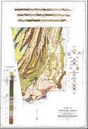
Title/Description:
Geologic Map of the Coastal Plain of Georgia
Publication Info:
Washington, D.C: Department of the Interior, US Geological Survey, 1940; Bulletin 941, Plate 1
Viewing Options
Main Author:
Butts, Charles
Title/Description:
Geologic Map of Northwest Georgia
Publication Info:
Atlanta: Georgia Depatment of Mines, Mining and Geology, 1946

Viewing Options
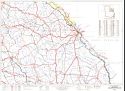
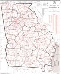
Main Author:
State Highway Department of Georgia
Title/Description:
State of Georgia, System of State Roads
Publication Info:
Atlanta: 1946
Viewing Options
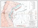
Main Author:
Geological Survey of Georgia
Title/Description:
Geologic Map of Chatsworth Talc District, Murray County, Georgia
Publication Info:
Atlanta: Geological Survey of Georgia, 1947; from Bulletin No. 53

Viewing Options
Main Author:
U.S. Department of Commerce, Bureau of the Census
Title/Description:
Georgia Minor Civil Divisions - Militia Districts (1950 census)
Publication Info:
Washington: U.S. Government Printing Office, 1952

Viewing Options
Main Author:
Geological Survey of Georgia
Title/Description:
Geologic Map of Thomaston Quadrangle, Georgia
Publication Info:
Atlanta: Geological Survey of Georgia, 1952; from Bulletin No. 59
Viewing Options
Main Author:
U.S. Geological Survey
Title/Description:
Geologic Map of the Upper Cretaceous Formations of Georgia
Publication Info:
Washington: Department of the Interior, U.S. Geological Survey, 1955; Bulletin 1014 Plate 1

Viewing Options
Main Author:
U.S. Department of Commerce, Bureau of the Census
Title/Description:
Georgia Census County Divisions (1960 census)
Publication Info:
Washington: U.S. Government Printing Office, 1961

Viewing Options
Main Author:
Smith, J. Harmon
Title/Description:
State of Georgia Showing the major campaign areas and engagement sites of The War Between the States, 1861-1865
Publication Info:
Atlanta: Georgia Department of Commerce, 1961
Viewing Options
Main Author:
State Highway Department of Georgia
Title/Description:
The State of Georgia, Civil War Centennial, 1864, Showing the Major campaign areas and engagement sites of the union and confederate armies
Publication Info:
Atlanta: State Highway Department of Georgia, 1964

Viewing Options
Main Author:
State of Georgia
Title/Description:
Mineral Resource Map
Publication Info:
Atlanta: State of Georgia, Division of Conservation, Department of Mines, Mining and Geology 1969
Viewing Options
Main Author:
U.S. Post Office Department
Title/Description:
State Postal Map, Georgia
Publication Info:
Washington: U.S. Government Printing Office, 1970

Viewing Options
Title/Description:
Geologic Map of Georgia
Publication Info:
Atlanta: Georgia Geological Survey, 1976