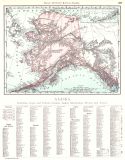
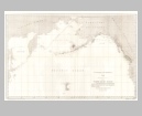
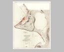
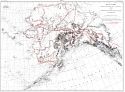
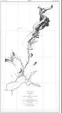
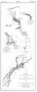
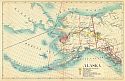
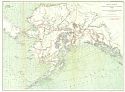
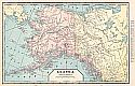
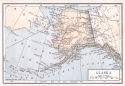
Viewing Options
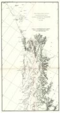
Main Author:
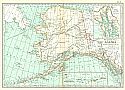
U.S. Coast and Geodetic Survey
Title/Description:
General Chart of Alaska
Publication Info:
Washington: U.S. Coast and Geodetic Survey, 1896
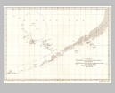
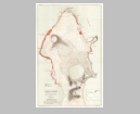
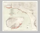
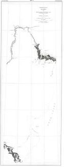
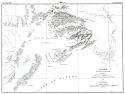
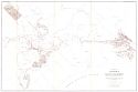
Viewing Options
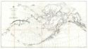
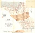
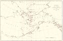
Main Author:
U.S. Coast and Geodetic Survey
Title/Description:
Sketch Showing the Progress of Surveys Locating the Boundary between Alaksa and British Possessions in North America
Publication Info:
Washington: U.S. Coast and Geodetic Survey, 1896
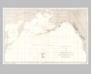
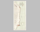
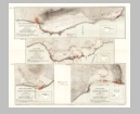
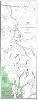
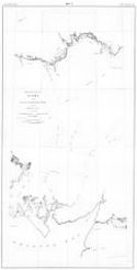
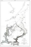
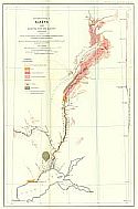
Viewing Options
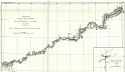
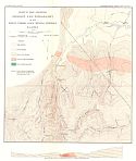
Main Author:
Turner, J.H.
Title/Description:
Sketch of Porcupine River from the Boundary to Fort Yukon, Alaska
Publication Info:
Washington: U.S. Coast and Geodetic Survey, 1896
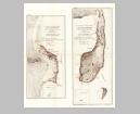
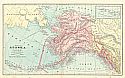
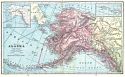
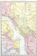
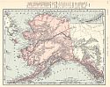
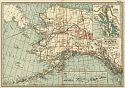
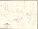
Viewing Options
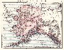
Main Author:
Rand McNally and Company
Title/Description:
Alaska
Publication Info:
Chicago: Rand McNally and Company,1896; from Indexed Atlas of the World
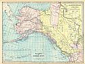
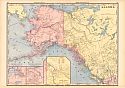
Viewing Options
Main Author:
Rand McNally and Company
Title/Description:
Alaska
Publication Info:
Chicago: Rand McNally and Company, 1896; from Enlarged Business Atlas
Viewing Options
Main Author:
U.S. Commissioner of Fish and Fisheries
Title/Description:
Chart Showing the Position and Number of Seals Taken in Bering Sea by the Schooner Lewis Olsen in 1894 and the Schooner Dora Siewerd in 1895
Publication Info:
Washington: Government Printing Office, 1896
Viewing Options
Main Author:
U.S. Commissioner of Fish and Fisheries
Title/Description:
Map of Bering Sea and the North Pacific Ocean Showing the Locations at Different Seasons of the Catch of Fur Seals in 1895
Publication Info:
Washington: Government Printing Office, 1896
Viewing Options
Main Author:
U.S. Commissioner of Fish and Fisheries
Title/Description:
Map of Bering Sea and the North Pacific Ocean Showing the Locations at Different Seasons of the Catch of Fur Seals in 1894
Publication Info:
Washington: Government Printing Office, 1896
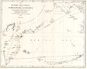
Viewing Options
Main Author:
U.S. Commissioner of Fish and Fisheries
Title/Description:
Map of Bering Sea and the North Pacific Ocean Showing the Locations at Different Seasons of the Catch of Fur Seals from 1883 to 1893
Publication Info:
Washington: Government Printing Office, 1896
Viewing Options
Main Author:
U.S. Commissioner of Fish and Fisheries
Title/Description:
Northeast Point Rookery, St. Paul Island, Bering Sea
Publication Info:
Washington: Government Printing Office, 1896
Viewing Options
Main Author:
U.S. Commissioner of Fish and Fisheries
Title/Description:
Polavina Rookery, St. Paul Island, Bering Sea
Publication Info:
Washington: Government Printing Office, 1896
Viewing Options
Main Author:
U.S. Commissioner of Fish and Fisheries
Title/Description:
Ketavie and Lukannon Rookery and Reef and Garbotch Rookeries, St. Paul Island, Bering Sea
Publication Info:
Washington: Government Printing Office, 1896
Viewing Options
Main Author:
U.S. Commissioner of Fish and Fisheries
Title/Description:
Tolstoi and Lagoon Rookeries, St. Paul Island, Bering Sea
Publication Info:
Washington: Government Printing Office, 1896
Viewing Options
Main Author:
U.S. Commissioner of Fish and Fisheries
Title/Description:
Zapadnie Rookery and English Bay, St. Paul Island, Bering Sea
Publication Info:
Washington: Government Printing Office, 1896
Viewing Options
Main Author:
U.S. Commissioner of Fish and Fisheries
Title/Description:
[Rookeries of St. George Island, Bering Sea]
Publication Info:
Washington: Government Printing Office, 1896
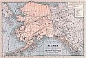
Viewing Options
Main Author:
Cram, George F.
Title/Description:
Map of Alaska
Publication Info:
Chicago: George F. Cram, 1897
Viewing Options
Main Author:
Matthews - Northrup Company
Title/Description:
Alaska
Publication Info:
New York: The Century Company, c1897; No. 58 from The Century Atlas
Viewing Options
Main Author:
U.S. Geological Survey
Title/Description:
Sketch Map Showing a portion of the Forty Mile Gold Mining District, Alaska
Publication Info:
Washington: Department of the Interior, U.S. Geological Survey, 1897; 18th Annual Report, Part 3, Plate 46
Viewing Options
Main Author:
U.S. Geological Survey
Title/Description:
Sketch Map Showing geology and topography of the Birch Creek Gold Mining District, Alaska
Publication Info:
Washington: Department of the Interior, U.S. Geological Survey, 1897; 18th Annual Report, Part 3, Plate 50
Viewing Options
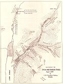
Main Author:
Talbot, C.B.
Title/Description:
Sketch of the Dyea and Skagua Trails
Publication Info:
Sitka, Alaska: C.B. Talbot, 1897
Viewing Options
Title/Description:
Sketch Map of Alaska to accompany Annual Report of the Governor of Alaska
Publication Info:
Washington:1897
Viewing Options
Main Author:
Cram, George F.
Title/Description:
Map of Alaska from Cram's Universal Atlas, Geographical, Astronomical and Historical
Publication Info:
Chicago: George F. Cram, 1898
Viewing Options
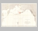
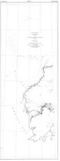
Main Author:
U.S. Coast and Geodetic Survey
Title/Description:
Route Map, Juneau to Porcupine River, Alaska
Publication Info:
Washington: U.S. Coast and Geodetic Survey, 1898
Viewing Options
Main Author:
U.S. Department of the Interior, U.S. Geological Survey
Title/Description:
Map of Alaska Showing Explorations by U.S. Geological Survey in 1898 together with Principal Previous Routes of Exploration
Publication Info:
Washington: U.S. Department of the Interior, U.S. Geological Survey, [1898] For Report No. 25, 55th Congress, 3rd Session
Viewing Options
Main Author:
U.S. Department of the Interior, U.S. Geological Survey
Title/Description:
Map2 Explorations in Alaska , 1898, Sushitna River and Adjacent Territory
Publication Info:
Washington: U.S. Department of the Interior, U.S. Geological Survey, [1898] For Report No. 25, 55th Congress, 3rd Session
Viewing Options
Main Author:
U.S. Department of the Interior, U.S. Geological Survey
Title/Description:
Map 3 Explorations in Alaska, 1898, Headwaters of Skwentna and Kuskokwim Rivers and Vicinity of Katmai
Publication Info:
Washington: U.S. Department of the Interior, U.S. Geological Survey, [1898] For Report No. 25, 55th Congress, 3rd Session
Viewing Options
Main Author:
U.S. Department of the Interior, U.S. Geological Survey
Title/Description:
Map 4 Explorations in Alaska, 1891, Middle Kuskokwim River and Part of Bristol Bay
Publication Info:
Washington: U.S. Department of the Interior, U.S. Geological Survey, [1898] For Report No. 25, 55th Congress, 3rd Session
Viewing Options
Main Author:
U.S. Department of the Interior, U.S. Geological Survey
Title/Description:
Map 5 Explorations in Alaska, 1891, Lower Kuskokwim River, Karektok River and Togiak Bay
Publication Info:
Washington: U.S. Department of the Interior, U.S. Geological Survey, [1898] For Report No. 25, 55th Congress, 3rd Session
Viewing Options
Main Author:
U.S. Department of the Interior, U.S. Geological Survey
Title/Description:
Map 6 Alaska, Route of Military Expedition in Charge of Captain E.F. Glenn, U.S.A., From Knik Arm to Tanana River
Publication Info:
Washington: U.S. Department of the Interior, U.S. Geological Survey, [1898] For Report No. 25, 55th Congress, 3rd Session
Viewing Options
Main Author:
U.S. Department of the Interior, U.S. Geological Survey
Title/Description:
Map 7 Alaska Military Expedition in Charge of Captain W.R. Abercrombie, U.S.A., Copper River and Adjacent Territory, 1898
Publication Info:
Washington: U.S. Department of the Interior, U.S. Geological Survey, [1898] For Report No. 25, 55th Congress, 3rd Session
Viewing Options
Main Author:
U.S. Department of the Interior, U.S. Geological Survey
Title/Description:
Alaska Military Expedition in Charge of Captain W.R. Abercrombie, U.S.A., Prince William Sound and Vicinity
Publication Info:
Washington: U.S. Department of the Interior, U.S. Geological Survey, [1898] For Report No. 25, 55th Congress, 3rd Session

Viewing Options
Main Author:
U.S. Department of the Interior, U.S. Geological Survey
Title/Description:
Map 9 Explorations of Alaska, 1898 Portions of Tanana and White Rivers
Publication Info:
Washington: U.S. Department of the Interior, U.S. Geological Survey, [1898] For Report No. 25, 55th Congress, 3rd Session
Viewing Options
Main Author:
U.S. Department of the Interior, U.S. Geological Survey
Title/Description:
Map 10 Alaska, Fortymile Quadrangle
Publication Info:
Washington: U.S. Department of the Interior, U.S. Geological Survey, [1898] For Report No. 25, 55th Congress, 3rd Session
Viewing Options
Main Author:
Surveyor General's Office
Title/Description:
Alaska
Publication Info:
New York: The Century Company, 1898
Viewing Options
Main Author:
Rand McNally & Company
Title/Description:
Alaska
Publication Info:
Chicago: Rand McNally & Co., 1898
Viewing Options
Main Author:
U.S. Department of the Interior, U.S. Geological Survey
Title/Description:
Geological Reconnaissance Map of a Port of The Copper River and Adjacent Territory, Alaskan Military Expedition
Publication Info:
Washington: Department of the Interior, U.S. Geological Survey, 1898; Twentieth Annual Report. Part VII, Map No. 21
Viewing Options
Main Author:
U.S. Department of the Interior, U.S. Geological Survey
Title/Description:
Explorations in Alaska, 1898, Sushitna River and Adjacent Territory
Publication Info:
Washington: Department of the Interior, U.S. Geological Survey, 1898; Twentieth Annual Report, Part VII, Map No. 3
Viewing Options
Main Author:
U.S. Department of the Interior, U.S. Geological Survey
Title/Description:
Map of Alaska Showing Explorations by U.S. Geological Survey in 1898 together with principal Previous Routes of Exploration
Publication Info:
Washington: Department of the Interior, U.S. Geological Survey, 1898; Twentieth Annual Report, Part VII, Map No. 1
Viewing Options
Title/Description:
Alaska
Publication Info:
New York: Funk & Wagnalls Company, 1898; from A Standard Atlas of the World
Viewing Options
Main Author:
Mast, Crowell, and Kirkpatrick
Title/Description:
Alaska and Part of British America
Publication Info:
Chicago: Mast, Crowell and Kirkpatrick, 1898
Viewing Options
Main Author:
Miller, J. Martin
Title/Description:
Alaska and Klondike Region
Publication Info:
Chicago: J. Martin Miller, 1899
Viewing Options
Main Author:
Cram, George F.
Title/Description:
Alaska
Publication Info:
Chicago: George F. Cram, 1899
Viewing Options
Main Author:
Smith, Benjamin E.
Title/Description:
Alaska
Publication Info:
New York: The Century Company, 1899; from The Century Atlas of the World
Viewing Options
Main Author:
Cram, George F.
Title/Description:
Alaska
Publication Info:
Chicago: George F. Cram, 1899; from The Standard American Railway System Atlas
Viewing Options
Main Author:
U.S. Navy, Hydrographic Office
Title/Description:
Map of Bering Sea Coast of Kamtschatka and Siberia
Publication Info:
Washington: Untied States Senate, 1899; from US Hydrographic Chart No 68, 56th Congress, 1st Session, Sen Doc 245
Viewing Options
Main Author:
The Bradstreet Company
Title/Description:
Alaska
Publication Info:
New York: The Bradstreet Company, 1899; from Bradstreet's Pocket Atlas of the United States
Viewing Options
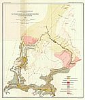
Main Author:
U.S. Geological Survey
Title/Description:
Fortymile Quadrangle Land Classification and Density of Standing Timber
Publication Info:
Washington D.C.: U.S. Geological Survey, 1899
Viewing Options
Main Author:
Peters, W.J.
Title/Description:
Explorations in Alaska, Route from Lynn Canal via headwaters of White and Tanana Rivers to Eagle City
Publication Info:
Washington: Department of the Interior, U.S. Geological Survey, 1900; 21st Annual Report, Part 2, Plate 43
Viewing Options
Title/Description:
Sketch Map of Cape Nome Mining Region and Adjacent Territory, Alaska
Publication Info:
New York: Julius Bien and Company, 1900

