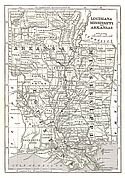
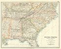
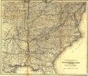
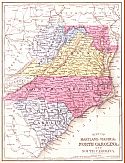
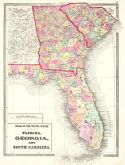
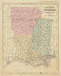
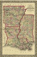
Viewing Options
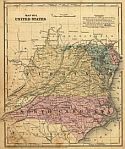
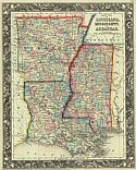
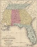
Main Author:
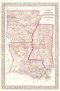
Morse, Sidney E.
Title/Description:
Louisiana, Mississippi and Arkansas
Publication Info:
New York: Harper and Brothers 1851; from Morse's School Geography
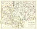
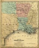
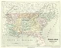
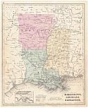
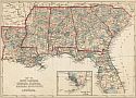
Viewing Options
Main Author:
Society for the Diffusion of Useful Knowledge
Title/Description:
North America Sheet XIII Parts of Louisiana, Arkansas, Mississippi, Alabama, and Florida
Publication Info:
London: Charles Knight, 1852; from The General Atlas
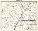
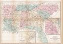
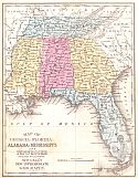
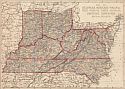
Viewing Options
Main Author:
Society for the Diffusion of Useful Knowledge
Title/Description:
North America, Sheet X, Parts of Missouri, Illinois, Kentucky, Tennessee, Alabama, Mississippi and Arkansas
Publication Info:
London: Charles, Knight, 1852; from The General Atlas
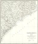
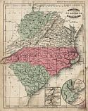
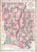
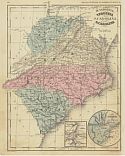
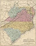
Viewing Options
Main Author:
Society for the Diffusion of Useful Knowledge
Title/Description:
Parts of North and South Carolina
Publication Info:
London: Charles Knight, 1852; from The General Atlas
Viewing Options
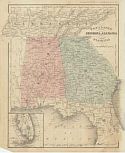
Main Author:
Society for the Diffusion of Useful Knowledge
Title/Description:
Georgia with parts of North and South Carolina, Tennessee, Alabama and Florida
Publication Info:
London: Charles Knight, 1852; from The General Atlas
Viewing Options
Main Author:
Society for the Diffusion of Useful Knowledge, Tanner & Smith
Title/Description:
North America, Sheet XIII: Parts of Louisiana, Arkansas, Mississippi, Alabama and Florida
Publication Info:
London: Baldwin and Gradock, 1853
Original Source:
Courtesy of Tom McMillan; Brewton, Alabama
Viewing Options
Title/Description:
Georgia, Alabama, and Florida
Publication Info:
New York: Francis McNally, 1854; from The System of Geography
Viewing Options
Main Author:
Cornell, Sarah Sophia
Title/Description:
Southern Division of the United States
Publication Info:
New York: D. Appleton & Co., 1855; designed to accompany Cornell's High School Geography
Viewing Options
Main Author:
Smith, Roswell C.
Title/Description:
Map No. 4 United States (Virginia, Maryland, Delaware and North Carolina)
Publication Info:
New York: Daniel Burgess and Co., 1855; from A concise and practical system of Geography for Schools, Academies and Families
Viewing Options
Main Author:
Smith, Roswell C.
Title/Description:
Map No. 5 United States (South Carolina, Georgia, Alabama and Florida)
Publication Info:
New York: Daniel Burgess and Co., 1855; from A concise and practical system of Geography for Schools, Academies and Families
Viewing Options
Main Author:
Smith, Roswell C.
Title/Description:
Map No. 6 United States (Mississippi, Arkansas, Louisiana, East Texas and Indian Territory)
Publication Info:
New York: Daniel Burgess and Co., 1855; from A concise and practical system of Geography for Schools, Academies and Families
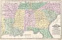
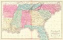
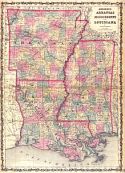
Viewing Options
Main Author:
Mitchell, S. Augustus
Title/Description:
Map of the Chief Part of the Southern States and Part of the Western States
Publication Info:
Philadelphia: Cowperthwait, Desilver and Butler, 1855
Viewing Options
Main Author:
Swanton, G.H.
Title/Description:
The South Eastern States
Publication Info:
Edinburgh: A. Fullerton and Company, c.1855

Viewing Options
Main Author:
Wells, Jacob
Title/Description:
Southern Division of the United States
Publication Info:
New York: D. Appleton and Company, 1856; to accompany Cornell's High School Geography
Viewing Options
Main Author:
Malte-Brun, Victor
Title/Description:
Etats-Unis Region du Sud
Publication Info:
Paris: Gustave Barba, 1856
Viewing Options
Main Author:
Richards, T. Addison
Title/Description:
Map of the Southern and South-Western States
Publication Info:
New York: D. Appleton and Company, 1857; from Appleton's Illustrated Hand Book of American Travel
Viewing Options
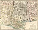
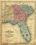
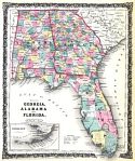
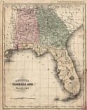
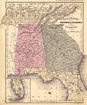
Main Author:
Colton, Joseph Hutchins
Title/Description:
Georgia, Alabama and Florida
Publication Info:
New York: J.H. Colton & Co., 1858
Viewing Options
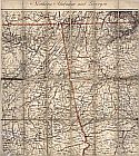
Main Author:
Colton, G.W. & C.B. Colton
Title/Description:
Map showing the route of the South & North Alabama Railroad and its connections
Publication Info:
New York: Colton, [1861?]
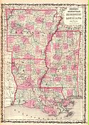
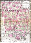
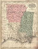
Viewing Options
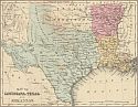
Main Author:
Mitchell, Samuel Augustus
Title/Description:
Map of Louisiana, Mississippi, and Arkansas
Publication Info:
Philadelphia: S.A. Mitchell, 1860
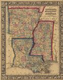
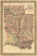
Viewing Options
Main Author:
Johnson, Alvin J.
Title/Description:
Johnson's Arkansas, Louisiana and Mississippi
Publication Info:
New York: Johnson and Browning, 1860
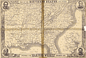
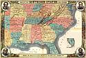
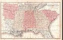
Viewing Options
Main Author:
Harper's Weekly
Title/Description:
Map of the Southern States
Publication Info:
New York: Harpers Weekly, November 1861
Viewing Options
Main Author:
Mitchell, S. Augustus, Jr.
Title/Description:
County Map of Louisiana, Mississippi and Arkansas
Publication Info:
Philadelphia: S. Augustus Mitchell, Jr., 1861; from Mitchell's New General Atlas
Viewing Options
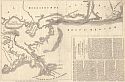
Main Author:
Harper's Weekly
Title/Description:
Map of the Coast Line from the Mouths of the Mississippi to Pensacola
Publication Info:
New York: Galvez Books, 1861; from the March 30, 1861 edition of Harper's Weekly, p 197
Original Source:
Courtesy of Tom McMillan; Brewton, Alabama
Viewing Options
Main Author:
Johnson, A.J.
Title/Description:
Johnson's Pennsylvania, Virginia, Delaware, and Maryland
Publication Info:
New York: Johnson and Ward, 1862; from The New Illustrated Family Atlas
Viewing Options
Main Author:
Johnson, A.J.
Title/Description:
Johnson's Arkansas, Mississippi, and Louisiana
Publication Info:
New York: Johnson and Ward, 1862; from The New Illustrated Family Atlas
Viewing Options
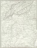
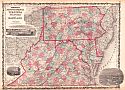
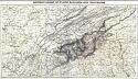
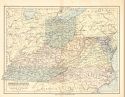
Main Author:
Nicholson, W.L. and A. Lindenkohl
Title/Description:
Mountain Region of North Carolina and Tennessee
Publication Info:
H. Lindenkohl and Charles G. Krebs, 1863
Viewing Options
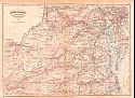
Main Author:
Nicholson, W.L. and A. Lindenkohl
Title/Description:
Mountain Region of North Carolina and Tennessee
Publication Info:
H. Lindenkohl and Charles G. Krebs, 1863
Viewing Options
Main Author:
Johnson, Alvin J.
Title/Description:
Johnson's Arkansas, Louisiana and Mississippi
Publication Info:
New York: Johnson and Ward, 1863
Viewing Options
Main Author:
Colton, G. Woolworth
Title/Description:
New Guide Map of the United States and Canada with Railroads, Counties, etc.
Publication Info:
New York: Julius Bien and Company, 1863; from The Atlas to Accompany the Official Records of the Union and Confederate Armies, 1861-1865
Viewing Options
Main Author:
U.S. Coast Survey Office
Title/Description:
Northern Alabama and Georgia
Publication Info:
Washington: U.S. Coast Survey Office, c.1865
Viewing Options
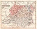
Main Author:
McNally, Francis
Title/Description:
Virginia, North Carolina, South Carolina
Publication Info:
New York: A.S. Barnes and Burr, 1865; from An Improved System of Geography
Viewing Options
Main Author:
McNally, Francis
Title/Description:
Georgia, Florida and Alabama
Publication Info:
New York: A.S. Barnes and Burr, 1865; from An Improved System of Geography
Viewing Options
Main Author:
McNally, Francis
Title/Description:
Mississippi, Louisiana, and Arkansas
Publication Info:
New York: A.S. Barnes and Burr, 1865; from An Improved System of Geography
Viewing Options
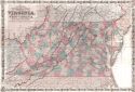
Main Author:
Mitchell, S. Augustus
Title/Description:
Map of Maryland, Virginia, North Carolina and South Carolina
Publication Info:
Philadelphia: S. Augustus Mitchell, 1865; from Mitchell's New Intermediate Geography
Viewing Options
Main Author:
Colton, J.H.
Title/Description:
Mississippi, Louisiana and Arkansas
Publication Info:
New York: Ivison, Phinney, Blakeman and Company, 1865; from American School Quarto Georgraphy
Viewing Options
Main Author:
Mitchell, S. Augustus
Title/Description:
Map of Maryland, Virginia, North Carolina, and South Carolina
Publication Info:
Philadelphia: S. Augustus Mitchell, 1865; from Mitchell's New Intermediate Geography
Viewing Options
Main Author:
Johnson, Alvin J.
Title/Description:
Johnson's Arkansas, Mississippi and Louisiana
Publication Info:
New York: Johnson and Ward, 1866
Viewing Options
Main Author:
Mitchell, S. Augustus
Title/Description:
County Map of the States of Arkansas, Mississippi and Louisiana
Publication Info:
Philadelphia: S. Augustus Mitchell, 1867; from Mitchell's New General Atlas
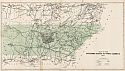
Viewing Options
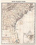
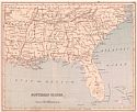
Title/Description:
South Atlantic States
Publication Info:
New York: Charles Scribner & Co., 1868; from Guyot's Common-School Geography
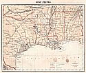
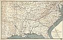
Viewing Options
Title/Description:
Gulf States
Publication Info:
New York: Charles Scribner & Co., 1868; from Guyot's Common-School Geography
Viewing Options
Main Author:
McNally, Francis
Title/Description:
Tennessee, Georgia, Florida, and Alabama
Publication Info:
[NY: Francis McNally, 1869]
Viewing Options
Main Author:
Colton, G.W. and C.B. Colton
Title/Description:
Colton's New Topographic Map of the States of Virginia, West Virginia, Maryland and Delaware
Publication Info:
Philadelphia: G.W. and C.B. Colton, 1869
Viewing Options
Main Author:
S. Augustus Mitchell
Title/Description:
Maryland, Virginia, West Virginia and North Carolina
Publication Info:
Philadelphia: E.H. Butler and Company, 1870; from Mitchell's New School Atlas
Viewing Options
Main Author:
S. Augustus Mitchell
Title/Description:
South Carolina, Georgia, Florida, Alabama, Mississippi, Louisiana, Tennessee and Arkansas
Publication Info:
Philadelphia: E.H. Butler and Company, 1870; from Mitchell's New School Atlas
Viewing Options
Main Author:
Johnston, W. and A.K.
Title/Description:
Map of the Southern States of North America
Publication Info:
London: Macmillan and Company, 1871
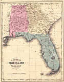
Viewing Options
Main Author:
Lloyd, H.H. and Company
Title/Description:
Atlas of the United States Florida, Georgia, and South Carolina
Publication Info:
New York: Warner & Beers, 1872; from H.H. Lloyd and Company's Atlas of the United States
Viewing Options
Main Author:
Hall, Mary L.
Title/Description:
Southern States
Publication Info:
Boston: Ginn Brothers, 1872; from Our World No. 2 or Second Series of Lessons in Geography
Viewing Options
Main Author:
Bartholomew, John
Title/Description:
Border States: Ohio, Kentucky, Virginia, W. Virginia, Maryland, Tennessee and N. Carolina
Publication Info:
Glascow: William Collins, Sonds and Company, 1872; from the Collegiate Atlas
Viewing Options
Main Author:
Asher and Adams
Title/Description:
Delaware, Maryland, Virginia, West Virginia
Publication Info:
New York: Asher and Adams, 1872; from New Statistical Atlas of the United States
Viewing Options
Main Author:
Bartholomew, John
Title/Description:
Tennessee, Georgia, Mississippi, Louisiana, Alabama, and Northern Part of Florida
Publication Info:
Philadelphia: T. Ellwood Zell, 1873; from Zell's Hand Atlas
Viewing Options
Main Author:
Lloyd, H.H. and Company
Title/Description:
Atlas of the United States, County Map of North Carolina, South Carolina, Georgia, and Florida
Publication Info:
New York: Warner & Beers, 1873; from H.H. Lloyd and Company's Atlas of the United States
Viewing Options
Main Author:
Jones, Charles H.
Title/Description:
Map of Delaware, Maryland, Virginia, West Virginia, North Carolina, Kentucky, Tennessee, Ohio, and Indiana
Publication Info:
New York: J. David Williams, 1873; The Peoples' Pictorial Atlas
Viewing Options
Main Author:
Jones, Charles H.
Title/Description:
Map of South Carolina, Georgia, Florida, Alabama, Mississippi and Louisiana
Publication Info:
New York: J. David Williams, 1873; The Peoples' Pictorial Atlas
Viewing Options
Main Author:
McNally, Francis
Title/Description:
W. Virginia, Virginia, N. Carolina, S. Carolina
Publication Info:
Chicago: A.S. Barnes and Company, 1873; from An Improved System of Geography
Viewing Options
Main Author:
McNally, Francis
Title/Description:
Tennessee, Georgia, Alabama and Florida
Publication Info:
Chicago: A.S. Barnes and Company, 1873; from An Improved System of Geography
Viewing Options
Main Author:
McNally, Francis
Title/Description:
Mississippi, Louisiana and Arkansas
Publication Info:
Chicago: A.S. Barnes and Company, 1873; from An Improved System of Geography

Viewing Options
Main Author:
Warner and Beers; H.H. Lloyd
Title/Description:
Map of the Southern States
Publication Info:
Chicago: Warner and Beers, c.1873
Viewing Options
Main Author:
Mitchell, S. Augustus
Title/Description:
County Map of the States of Arkansas, Mississippi, and Louisiana
Publication Info:
Philadelphia: S. A. Mitchell, 1873; from Mitchell's New General Atlas
Viewing Options
Main Author:
Mitchell, S. Augustus
Title/Description:
County Map of the States of Arkansas, Mississippi and Louisiana
Publication Info:
Philadelphia: S. Augustus Mitchell, 1874; from Mitchell's New General Atlas
Viewing Options
Main Author:
Jones, Charles H. and Theodore F. Hamilton
Title/Description:
Map of Delaware, West Virginia, Maryland, Virginia, North Carolina, Kentucky, Tennessee, Ohio and Indiana
Publication Info:
Chicago: H.H. Hardesty, 1875; from The Historical Atlas of the World Illustrated
Viewing Options
Main Author:
Jones, Charles H. and Theodore F. Hamilton
Title/Description:
Map of South Carolina, Georgia, Florida, Alabama, Mississippi and Louisiana
Publication Info:
Chicago: H.H. Hardesty, 1875; from The Historical Atlas of the World Illustrated
Viewing Options
Main Author:
Mitchell, S. Augustus
Title/Description:
Map of Maryland, Virginia, North Carolina and South Carolina
Publication Info:
Philadelphia: J.H. Butler and Company, 1875; from A System of Modern Geography
Viewing Options
Main Author:
Mitchell, S. Augustus
Title/Description:
Map of Georgia, Florida, Alabama, Mississippi and Tennessee
Publication Info:
Philadelphia: J.H. Butler and Company, 1875; from A System of Modern Geography
Viewing Options
Main Author:
Mitchell, S. Augustus
Title/Description:
Map of Louisiana, Texas and Arkansas
Publication Info:
Philadelphia: J.H. Butler and Company, 1875; from A System of Modern Geography

