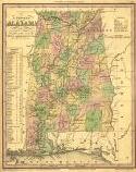
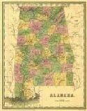
Viewing Options
Main Author:
Tanner, Henry Schenk
Title/Description:
A New Map of Alabama
Publication Info:
Philadelphia: H.S. Tanner, 1836
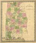
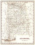
Viewing Options
Main Author:
Greenleaf, Jeremiah
Title/Description:
Map of the State of Alabama
Publication Info:
[Brattleboro, VT: J. Greenleaf, 1836]
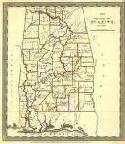
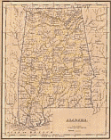
Viewing Options
Main Author:
Burr, David H.
Title/Description:
Map of the State of Alabama
Publication Info:
New York: Illman & Pilbrow, 1836
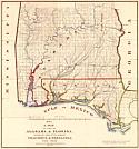
Viewing Options
Main Author:
Palmer, Wm. R.
Title/Description:
A Map of Part of Alabama and Florida shewing(sic) the route of the proposed Columbus and Pensacola Railroad
Publication Info:
To accompany the report of Major J.D. Graham, U.S. Topographical Engineer
Main Author:
LaTourette, John
Title/Description:
An Accurate Map of the State of Alabama and West Florida
Publication Info:
New York: Colton & Co., 1837
Sheet 1: Insets of University of Alabama and Huntsville
Sheet 15: Macon, Montgomery, Pike, Tallapoosa
Sheet 2: Cherokee, DeKalb, Jackson
Sheet 16: Autauga, Bibb, Dallas, Jefferson, Perry, Shelby
Sheet 3: Blount, Jackson, Limestone, Madison, Marshall, Morgan
Sheet 17: Macon, Montgomery, Pike, Tallapoosa
Sheet 4: Franklin, Lauderdale, Lawrence, Marion, Walker
Sheet 18: 1830 Census Statistics
Sheet 5: Insets of State Capitol, Florence
Sheet 19: Autauga, Butler, Dallas, Lowndes, Perry, Wilcox
Sheet 6: Insets of Tuscaloosa and Tuscumbia
Sheet 20: Clarke, Conecuh, Dallas, Marengo, Monroe, Wilcox
Sheet 7: Bibb, Jefferson, Shelby, Tuscaloosa, Walker
Sheet 21: Baldwin, Clarke, Marengo, Washington
Sheet 8: Fayette, Greene, Perry, Pickens, Sumter, Tuscaloosa
Sheet 22: Insets of Mobile and Mt. Vernon Arsenal
Sheet 9: Benton, Coosa, Randolph, St. Clair, Talladega, Tallapoosa
Sheet 23: Baldwin, Mobile
Sheet 10: Insets of Montgomery and Wetumpka, U.S. Presidents
Sheet 24: Butler, Conecuh, Covington, and Escambia and Walton Counties (Florida)
Sheet 11: Chambers, Macon, Randolph, Russell, Tallapoosa
Sheet 25: Map Certification
Sheet 12: Autauga, Bibb, Coosa, Montgomery, Shelby, Talladega
Sheet 13: U.S. Presidents
Sheet 27: Walton and Washington Counties (Florida)
Sheet 14: Barbour, Dale, Henry Pike
Sheet 28: Insets of Pensacola and Fort Morgan
Viewing Options
Main Author:
Bradford, Thomas Gamaliel
Title/Description:
Alabama
Publication Info:
Boston: T.G. Bradford, 1838
Viewing Options
Main Author:
Bradford, Thomas Gamaliel
Title/Description:
Alabama
Publication Info:
Boston: T.G. Bradford, 1838
Viewing Options
Main Author:
Bradford, Thomas Gamaliel
Title/Description:
Alabama
Publication Info:
Plate from and unidentified atlas, c.1840
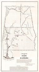
Viewing Options
Main Author:
Weakley, James H.
Title/Description:
A diagram of the State of Alabama
Publication Info:
Florence: James H. Weakley, Surveyor General of Public Lands in Alabama, 1840