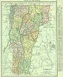
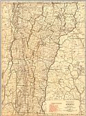
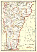
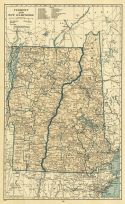
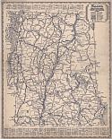
Viewing Options
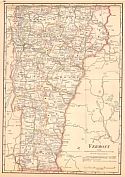
Main Author:
Rand McNally and Company
Title/Description:
Vermont
Publication Info:
Chicago: Rand McNally and Co., 1916; from The Ideal Atlas of the World
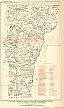
Viewing Options
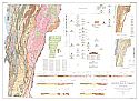
Main Author:
U.S. Geological Survey
Title/Description:
Map Of Vermont Showing Principal Drainage And Location Of Gaging Stations
Publication Info:
Washington: Department of the Interior, U.S. Geological Survey, 1917; Water Supply Paper No. 424 Plate 1
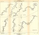
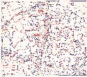
Viewing Options
Main Author:
U.S. Geological Survey
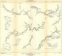
Title/Description:
Rover Surveys- Winooski River Drainage Basin, Vermont- Mad and Waterbury Rivers
Publication Info:
Washington: Department of the Interior, U.S. Geological Survey, 1917; Water Supply Paper No. 424 Plate 2
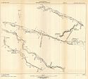
Viewing Options
Main Author:
U.S. Geological Survey
Title/Description:
River Surveys- Winooski River, Vermont, Sheet A
Publication Info:
Washington: Department of the Interior, U.S. Geological Survey, 1917; Water Supply Paper No. 424 Plate 3
Viewing Options
Main Author:
U.S. Geological Survey
Title/Description:
River Surveys- Winooski River, Vermont, Sheet B
Publication Info:
Washington: Department of the Interior, U.S. Geological Survey, 1917; Water Supply Paper No. 424 Plate 4
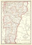
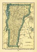
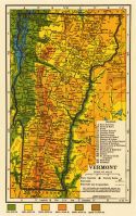
Viewing Options
Main Author:
Cram, George F.
Title/Description:
Vermont
Publication Info:
Chicago: George F. Cram, 1920; from Descriptive Review Showing Development of the State of Pennsylvania
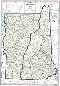
Viewing Options
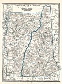
Main Author:
C.S. Hammond and Company
Title/Description:
Vermont and New Hampshire
Publication Info:
New York: C.S. Hammond and Company, 1920; from The New Reference Atlas of the World
Original Source:
Courtesy of Shawn Carter
Viewing Options
Main Author:
Leslie-Judge Company
Title/Description:
Vermont and New Hampshire
Publication Info:
New York: Leslie-Judge Company1920; from Leslie's New World Atlas
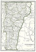
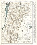
Viewing Options
Main Author:
Rand McNally and Company
Title/Description:
Vermont
Publication Info:
Chicago: Rand McNally and Company, 1921; from The Commercial Atlas of America
Viewing Options
Main Author:
Cram, George F.
Title/Description:
Vermont
Publication Info:
Chicago: George F. Cram Company, 1921; from Cram's Unrivaled Atlas of the World
Viewing Options
Main Author:
National Map Company
Title/Description:
Vermont
Publication Info:
Indianapolis: National Map Company, 1921; from Auto Trails and Commercial Survey of the United States
Viewing Options
Main Author:
National Map Company
Title/Description:
Vermont
Publication Info:
Indianapolis: National Map Company, 1921; from Auto Trails and Commercial Survey of the United States
Viewing Options
Main Author:
Cram, George F.
Title/Description:
Vermont
Publication Info:
Chicago: George F. Cram Company, 1923; from Cram's Unrivaled Atlas of the World
Viewing Options
Main Author:
Funk and Wagnalls Company
Title/Description:
Vermont
Publication Info:
New York: Funk and Wagnalls Company, 1923; from Atlas of the World and Gazetteer
Viewing Options
Main Author:
Rand McNally and Company
Title/Description:
Vermont
Publication Info:
Chicago: Rand McNally and Company, 1925; from Premier Atlas of the World
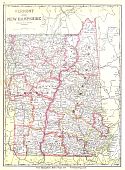
Viewing Options
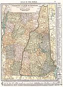
Main Author:
National Map Company
Title/Description:
Vermont and New Hampshire
Publication Info:
Indianapolis: National Map Company, 1930; from Official Paved Road and Commercial Survey of the United States
Viewing Options
Main Author:
C.S. Hammond and Company
Title/Description:
Vermont and New Hampshire
Publication Info:
New York: C.S. Hammond and Company, c. 1930; from The New World Loose Leaf Atlas, Sixth Edition
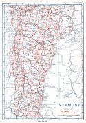
Viewing Options
Main Author:
C.S. Hammond and Company
Title/Description:
Vermont
Publication Info:
New York: C.S. Hammond and Company, c. 1930; from The New World Loose Leaf Atlas, Sixth Edition
Viewing Options
Main Author:
Geographical Publishing Company
Title/Description:
Vermont
Publication Info:
Chicago: Geographical Publishing Company1931; from Commercial Atlas of the World
Viewing Options
Main Author:
Rand McNally and Company
Title/Description:
Standard Map of Vermont
Publication Info:
Chicago: Rand McNally and Company, 1936
Viewing Options
Main Author:
The Mid-West Map Company
Title/Description:
Sears Official Road Map, Vermont and New Hampshire
Publication Info:
Aurora, MO: Mid-West Map Company, c.1937
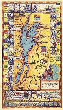
Viewing Options
Main Author:
Lake Champlain Bridge Commission
Title/Description:
An Historical Map of the Lake Champlain Tour Along the Warpath of the Nations
Publication Info:
Lake Champlain Bridge Commission, 1939
Original Source:
Murray Hudson
Viewing Options
Main Author:
Lake Champlain Bridge Commission
Title/Description:
Main Routes to Lake Champlain Bridges
Publication Info:
Lake Champlain Bridge Commission, 1939
Original Source:
Murray Hudson
Viewing Options
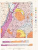
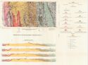
Main Author:
Doll, Charles G.
Title/Description:
Geologic Map and Structure Sections of the Irasburg-Memphremagog Area, Vermont
Publication Info:
Montpelier: Vermont Development Commission, 1951; from Vermont Geological Survey, Bulletin 3
Viewing Options
Main Author:
Osberg, Philip Henry
Title/Description:
Geologic Map of the East Middleburg-Rochester Area, Vermont
Publication Info:
Montpilier: Vermont Development Commission, 1952; from Vermont Geological Survey Bulletin 5
Viewing Options
Main Author:
Brace, William F.
Title/Description:
Areal Geology of the Rutland Area, Vermont
Publication Info:
Montpelier: Vermont Development Commission, 1953; Vermont Geological Survey Bulletin 6
Viewing Options
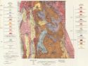
Main Author:
Vermont Geological Survey
Title/Description:
Geologic Map of Vermont
Publication Info:
Waterbury: Vermont Geological Survey, 1961
Viewing Options
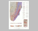
Main Author:
U.S. Geological Survey
Title/Description:
Geologic Map and Structure Sections of the Upper Missiquoi Valley and Vicinity, Vermont
Publication Info:
Washington: Department of the Interior, U.S. Geological Survey, 1963; Bulletin 1122-B Plate 1

