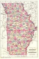
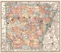
Viewing Options
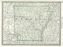
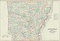
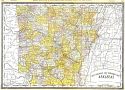
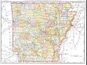
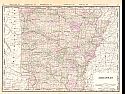
Main Author:
Bradley, William M.
Title/Description:
County Map of Missouri and Arkansas
Publication Info:
Philadelphia: Bradley &Co., 1881
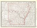
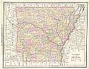
Viewing Options
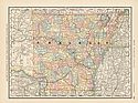
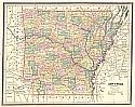
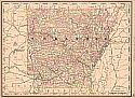
Main Author:
Rand McNally and Company
Title/Description:
Arkansas
Publication Info:
Chicago: Rand McNally and Company, 1881; from New Indexed Business Atlas and Shippers Guide
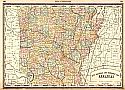
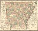
Viewing Options
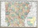
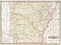
Main Author:
Hardesty, H.H.
Title/Description:
New Railroad and Township Map of Arkansas
Publication Info:
New York: H.H. Hardesty &Co., 1883; from Hardesty's Historical and Geographical Encyclopedia
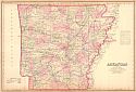
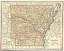
Viewing Options
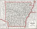
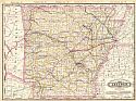
Title/Description:
Arkansas
Publication Info:
Philadelphia: O.W. Gray and Son, 1883; from The National Atlas
Viewing Options
Main Author:
Hardesty, H.H.
Title/Description:
Arkansas
Publication Info:
Chicago: H.H. Hardesty & Company, 1883; from Hardesty's Historical & Geographical Encyclopedia, Illustrated
Viewing Options
Main Author:
Watson, Gaylord
Title/Description:
Arkansas
Publication Info:
Boston: Perry and Spaulding, 1883; from New Indexed Family Atlas of the United States with Maps of the World
Viewing Options
Main Author:
Rand McNally & Company
Title/Description:
Arkansas from Rand McNally Indexed Atlas of the World
Publication Info:
Chicago: Rand McNally & Co., 1884
Original Source:
From the peronal collection of Dr. Gerald Webster
Viewing Options
Main Author:
Cram, George F.
Title/Description:
Arkansas
Publication Info:
Chicago: Henry S. Stebbins, 1884; from The Unrivaled Family Atlas of the World
Viewing Options
Main Author:
Rand McNally and Company
Title/Description:
Arkansas
Publication Info:
Chicago: Rand McNally and Co., 1884; from The Indexed Atlas of the World
Original Source:
From the personal collection of Dr. Gerald Webster
Viewing Options
Main Author:
Rand McNally and Company
Title/Description:
Arkansas
Publication Info:
Chicago: Rand McNally and Company, 1884; from The New Household Atlas of the World
Viewing Options
Main Author:
Watson, Gaylord
Title/Description:
Watson's Atlas Map of Arkansas
Publication Info:
New York: Gaylord Watson, 1885; from Watson's New and Complete Illustrated Atlas of the World
Viewing Options
Main Author:
Cram, George F.
Title/Description:
Arkansas
Publication Info:
Chicago: Henry S. Stebbins, 1885; from The Unrivaled Family Atlas of the World
Viewing Options
Main Author:
Cram, George F.
Title/Description:
Arkansas
Publication Info:
Chicago: George F. Cram, c. 1886; for Gaskell's Atlas of the World
Viewing Options
Title/Description:
Arkansas
Publication Info:
Philadelphia: Stedman and Brown, 1886; from The National Atlas
Viewing Options
Main Author:
Cram, George F.
Title/Description:
Arkansas
Publication Info:
Chicago: Henry S. Stebbins, 1887; from Cram's Universal Atlas of the World
Viewing Options
Title/Description:
Railroad and County Map of Arkansas
Publication Info:
New York: A. A. Grant, 1887; from Grant's Standard American Atlas of the World
Viewing Options
Main Author:
Cram, George F
Title/Description:
Railroad and County Map of Arkansas
Publication Info:
Chicago: George F Cram, 1887, from Cram's Banker and Brokers Railroad Atlas
Viewing Options
Main Author:
Rand McNally & Company
Title/Description:
New Railroad and Township Map of Arkansas from the New Indexed Atlas of the World
Publication Info:
Chicago: Rand McNally & Co., 1888
Viewing Options
Main Author:
Rand McNally & Co.
Title/Description:
Arkansas
Publication Info:
Chicago: Rand McNally & Co., 1888; from Rand McNally's Standard Atlas of the World
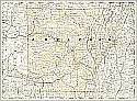
Viewing Options
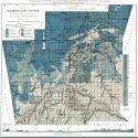
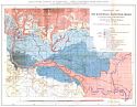
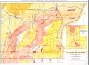
Main Author:
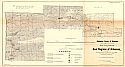
Geological Survey of Arkansas, John C. Branner, State Geologist
Title/Description:
Map of Washington County
Publication Info:
Little Rock: Geological Survey of Arkansas; 1888
Viewing Options
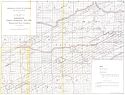
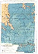
Main Author:
Comstock, T.B.
Title/Description:
Map of portions of Garland, Montgomery, Polk, Pike, Howard, and Servier Counties
Publication Info:
Little Rock: Geological Survey of Arkansas; 1888
Viewing Options
Main Author:
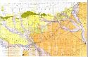
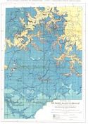
Geological Survey of Arkansas, John C. Branner, State Geologist
Title/Description:
Map Showig the Geology of Southwestern Arkansas
Publication Info:
Little Rock: Geological Survey of Arkansas; 1888
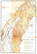
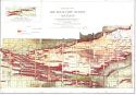
Viewing Options
Main Author:
Winslow, Arthur
Title/Description:
Map of a Portion of the Coal Regions of Arkansas
Publication Info:
Little Rock: Geological Survey of Arkansas; 1888; to accompany Vol. 3 of the Annual Report of 1888
Viewing Options
Main Author:
Rand McNally and Company
Title/Description:
Arkansas
Publication Info:
Chicago: Rand McNally and Co., 1889; from the Enlarged Business Atlas and Shippers Guide
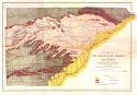
Viewing Options
Main Author:
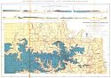
Geological Survey of Arkansas, John C. Branner, State Geologist
Title/Description:
Map of Crowley's Ridge and of the Flood Plains of Adjacent Streams
Publication Info:
Little Rock: Geological Survey of Arkansas; 1889
Viewing Options
Main Author:
Rand McNally &Company
Title/Description:
Arkansas
Publication Info:
Chicago: Rand McNally & Co., 1890; from Rand McNally and Company's Indexed Atlas of the World
Viewing Options
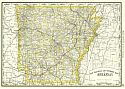
Main Author:
Alden, John B.
Title/Description:
Arkansas
Publication Info:
New York: John B. Alden, 1890
Viewing Options
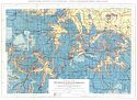
Main Author:
John C. Branner
Title/Description:
Geological Map of the Marble Region of Arkansas - Harrison Sheet
Publication Info:
Little Rock: Geological Survey of Arkansas; 1890
Viewing Options
Main Author:
John C. Branner
Title/Description:
Geological Map of the Marble Region of Arkansas - Batesville Sheet
Publication Info:
Little Rock: Geological Survey of Arkansas; 1889
Viewing Options
Main Author:
John C. Branner
Title/Description:
Geological Map of the Marble Region of Arkansas - Lead Hill Sheet
Publication Info:
Little Rock: Geological Survey of Arkansas; 1889
Viewing Options
Main Author:
John C. Branner
Title/Description:
Geological Map of the Marble Region of Arkansas - Eureka Springs Sheet
Publication Info:
Little Rock: Geological Survey of Arkansas; 1889

Viewing Options
Main Author:
John C. Branner
Title/Description:
Geological Map of the Marble Region of Arkansas - Mountain View Sheet
Publication Info:
Little Rock: Geological Survey of Arkansas; 1890
Viewing Options
Main Author:
John C. Branner
Title/Description:
Geological Map of the Marble Region of Arkansas - Carrollton Sheet
Publication Info:
Little Rock: Geological Survey of Arkansas; 1890
Viewing Options
Main Author:
John C. Branner
Title/Description:
Geological Map of the Batesville Manganese Region
Publication Info:
Little Rock: Geological Survey of Arkansas; 1890
Viewing Options
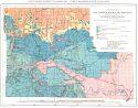
Main Author:
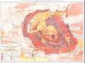
John C. Branner
Title/Description:
Geological Map of the Magnetic Cove Region
Publication Info:
Little Rock: Geological Survey of Arkansas; 1890
Viewing Options
Main Author:
John C. Branner
Title/Description:
Geological Map of the Fourche Mountain Region
Publication Info:
Little Rock: Geological Survey of Arkansas; 1890
Viewing Options
Main Author:
John C. Branner
Title/Description:
Geological Map of the Novaculite Region of Arkansas - Mt. Ida Sheet
Publication Info:
Little Rock: Geological Survey of Arkansas; 1890
Viewing Options
Main Author:
John C. Branner
Title/Description:
Geological Map of the Novaculite Region of Arkansas - Hot Springs Sheet
Publication Info:
Little Rock: Geological Survey of Arkansas; 1890
Viewing Options
Main Author:
Walker, Henry B.
Title/Description:
Arkansas
Publication Info:
Philadelphia: H.B. Walker, 1890; from Walker's International Atlas