Use the menu to the right to browse our collection of out-of-print editions of U.S.G.S. Quadrangles. Please keep in mind that map coverage varies and may not be complete for all counties.
Out-of-Print Quadrangles
Main Author
Alabama Highway Dept.
Alabama Highway Dept.
Alabama Highway Dept.
Alabama Highway Dept.
Alabama Highway Dept.
Alabama Highway Dept.
Alabama Highway Dept.
Alabama Highway Dept.
Location
Jefferson County
Jefferson County
Jefferson County
Jefferson County
Jefferson County
Jefferson County
Jefferson County
Jefferson County
Publication Information
Montgomery: ASHD
Montgomery: ASHD
Montgomery: ASHD
Montgomery: ASHD
Montgomery: ASHD
Montgomery: ASHD
Montgomery: ASHD
Montgomery: ASHD
Date
2005
1995
1983
1967
1960
1942
1938
1937
Scale
1:125,000
1:125,000
1:125,000
1:125,000
1:125,000
1:125,000
1:125,000
1:125,000
Viewing Options
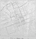
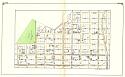
Title/Description:
Town of Elyton, 1821
Publication Info:
hand drawn map by an unknown author
Viewing Options
Main Author:
LaTourrette, John
Title/Description:
An Accurate Map of the State of Alabama and West Florida [Sheet 17: Bibb, Jefferson, Shelby, Tuscaloosa, Walker]
Publication Info:
New York: Colton & Co., 1837
Viewing Options
Main Author:
LaTourrette, John
Title/Description:
An Accurate Map of the State of Alabama and West Florida [Sheet 16: Autauga, Bibb, Dallas, Jefferson, Perry, Shelby]
Publication Info:
New York: Colton & Co., 1837
Viewing Options
Main Author:
Barker, William P.
Title/Description:
Birmingham Alabama and the Adjacent Property of the Elyton Land Company
Publication Info:
New York: C.W. and C.B. Colton and Company, 1871
Viewing Options
Main Author:
Barker, William P.
Title/Description:
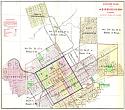
Map of the City of Birmingham, Alabama
Publication Info:
New York: G.W. and C.B. Colton and Co. [c. 1880]; for the Elyton Land Company
Viewing Options
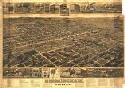
Title/Description:
Birmingham, Alabama
Publication Info:
Milwaukee: Norris, Wellge and Co., 1885
Viewing Options
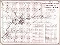
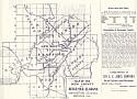
Main Author:
Riccio, Sloan, and Vedeler
Title/Description:
The Mining, Metallurgic and Industrial District of Birmingham
Viewing Options
Viewing Options
Viewing Options
Viewing Options
Viewing Options
Viewing Options
Viewing Options
Viewing Options
Viewing Options
Viewing Options
Viewing Options
Viewing Options
Viewing Options
Viewing Options
Viewing Options
Viewing Options
Viewing Options
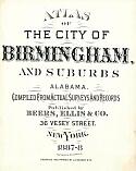
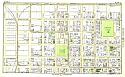
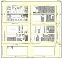
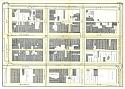
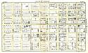
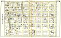
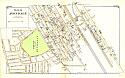
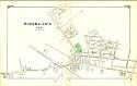
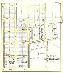
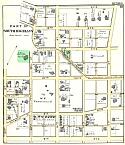
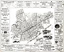
Title/Description:
Atlas of the City of Brimingham and Suburbs
Publication Info:
New York: Beers, Ellis, and Co., 1887-1888
Scale:
various sizes and scales
Viewing Options
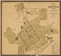
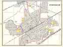
Title/Description:
Map of the City of Birmingham, Alabama and Suburbs
Publication Info:
Chicago: Rand McNally & Co., 1888; for the Elyton Land Co.
Viewing Options
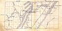
Main Author:
Fitzhugh, G.D.
Title/Description:
Manuscript map of Southwestern Jefferson County, Township 19S, Ranges 4 and 5 West
Publication Info:
Unpublished, c.1888; for the Louisville and Nashville Railroad
Viewing Options
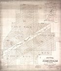
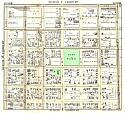
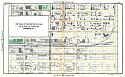
Title/Description:
Map of Jefferson County, Alabama
Publication Info:
Birmingham: E. Grieg, 1889
Viewing Options
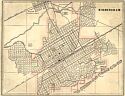
Main Author:
Cram, George F.
Title/Description:
Birmingham
Publication Info:
Chicago: George F. Cram, 1892; from Cram's Universal Atlas, Geographical, Astronomical and Historical
Viewing Options
Title/Description:
Map of Jefferson County, Alabama
Publication Info:
New York: New York Photgravure Co., 1892; compiled by the Elyton Land Company
Viewing Options
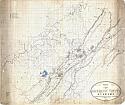
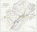
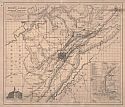
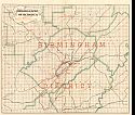
Main Author:
Turner, H.A.
Title/Description:
Map of Jefferson County and parts of Adjacent Co.'s including the Mineral District of Birmingham and showing the Lands of Its Different Companies Therein
Publication Info:
Birmingham, 1892
Viewing Options
Main Author:
Miller, John A.
Title/Description:
Map of Jefferson County, Alabama
Publication Info:
Dayton, Ohio: Walker Lith. Co., 1897
Viewing Options
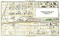
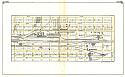
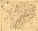
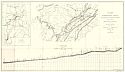
Main Author:
Ripley, Jospeh, Barnes, M.G., Swift, Andrew J., and Ferguson, O.W.
Title/Description:
Map and Profile of the Proposed Birmingham Canal
Publication Info:
Montgomery: Corps of Engineers, 1897
Viewing Options
Main Author:
Cram, George F.
Title/Description:
Birmingham
Publication Info:
Chicago: George F. Cram, 1898; from Cram's Universal Atlas, Geographical, Astronomical and Historical
Viewing Options
Main Author:
Bessemer Land and Improvement Co.
Title/Description:
Map of Bessemer, Alabama and Contiguous Territory
Publication Info:
New York: Julius Bien and Company, 1899
Viewing Options
Title/Description:
Map of the New County of Bessemer, Alabama and the Contributing Counties
Publication Info:
Bessemer: S.E. Jones & Co., 1900
Viewing Options
Title/Description:
Map of the New County of Bessemer, Alabama and the Contributing Counties
Publication Info:
Bessemer: S.E. Jones & Co., 1900, reverse side of previous map
Viewing Options
Main Author:
Tennessee Coal, Iron and Rail Road Company
Title/Description:
Map of the Birmingham, Alabama District
Publication Info:
Tennesee Coal, Iron, and Railroad Company, 1900
Viewing Options
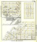
Main Author:
Parkes, W.J.
Title/Description:
Birmingham and Suburbs
Publication Info:
Birmingham: W.J. Parkes, 1900; photo copy of original

