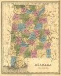
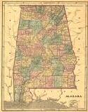
Viewing Options
Main Author:
Bradford, T.G.
Title/Description:
Plate from a universal illustrated atlas of 1838, corrected to 1846
Publication Info:
Unknown
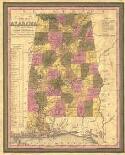
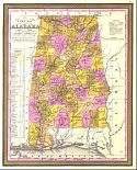
Viewing Options
Main Author:
Mitchell, Samuel Augustus
Title/Description:
A New Map of Alabama
Publication Info:
Philadelphia: S.A. Mitchell, 1846
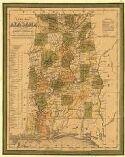
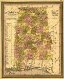
Viewing Options
Main Author:
Tanner, Henry Schenk
Title/Description:
A new map of Alabama with its roads & distances from place to place along the stage and steamboat routes
Publication Info:
Philadelphia: S. August Mitchell, 1847
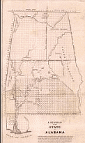
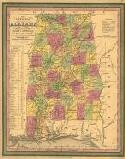
Viewing Options
Main Author:
Weakly, James Harvey
Title/Description:
A Diagram of the State of Alabama
Publication Info:
[Washington: U.S. Government Land Office, 1847]
Viewing Options
Main Author:
Morse, Sidney Edward
Title/Description:
Alabama
Publication Info:
New York: S.E. Morse & Co., 1848
Viewing Options
Main Author:
Mitchell, S. Augustus
Title/Description:
A New Map of Alabama with its Roads and Distances from place to place along the stage and steamboat routes
Publication Info:
Philadelphia: S.A. Mitchell, 1849
Viewing Options
Main Author:
Mitchell, S. Augustus
Title/Description:
A New Map of Alabama with its Roads and Distances from place to place along the stage and steamboat routes
Publication Info:
Philadelphia: S.A. Mitchell, 1850
Viewing Options
Main Author:
Thomas Cowperthwait & Co.
Title/Description:
A new map of Alabama with its roads and distances from place to place along the stage and steamboat routes
Publication Info:
Philadelphia: Thomas, Cowperthwait & Co., 1850