Historical Maps of Other Southeastern States

Selected Utah Out-of-Print Quadrangles
Before 1885
Before 1885
1885-1900
After 1900

 
Next Page

  Main Author:   Freemont, John Charles
  Title/Description:   The Great Salt Lake
  Publication Info:   Washington: Gales and Seaton, 1845; from The Report of the Exploring Expedition to the Rocky Mountains in the Year 1842, and to Oregon and North California in the Years 1843-44
  Date:   1845
  Scale:   1:1,000,000
  Original Source:   Courtesy of Murray Hudson, Halls, Tennessee
Viewing options:


  Main Author:   Gamble, William H.
  Title/Description:   County Map of Utah and Nevada
  Publication Info:   Philadelphia: S.A. Mitchell, 1864
  Date:   1864
  Scale:   1:3,041,000
  Original Source:   Courtesy of Murray Hudson, Halls, Tennessee
Viewing options:


  Main Author:   Mitchell, S. Augustus, Jr.
  Title/Description:   County Map of Utah and Nevada
  Publication Info:  

Philadelphia: S. Augustus Mitchell, Jr., 1868; from The New General Atlas

  Date:   1868
  Scale:   1:2,851,000
  Original Source:   University of Alabama Map Library
Viewing options:


  Main Author:   Bourquin, F.
  Title/Description:   Map of Utah to Accompany Beadle's History of the Mormans
  Publication Info:   Philadelphia: c.1870
  Date:   1870
  Scale:   1:3,041,000
  Original Source:   Courtesy of Murray Hudson, Halls, Tennessee
Viewing options:


  Main Author:   Froiseth, B.A.M.
  Title/Description:   Maps of Utah Territory, Great Salt Lake Valley, and Salt Lake City
  Publication Info:   New York: Skandinavisk Post, 1870
  Date:   1870
  Scale:   various
  Original Source:   Courtesy of Murray Hudson, Halls, Tennessee
Viewing options:


  Main Author:   Mitchell, S. Augustus
  Title/Description:   County Map of Utah and Nevada
  Publication Info:   Philadelphia: S. Augustus Mitchell, 1872
  Date:   1872
  Scale:   1:3,168,000
  Original Source:   Courtesy of Antique Atlas
Viewing options:


  Main Author:   Asher and Adams
  Title/Description:   Asher and Adams' Utah
  Publication Info:   New York: Asher and Adams, c.1873
  Date:   1873
  Scale:   1:1,267,000
  Original Source:   Courtesy of Murray Hudson, Halls, Tennessee
Viewing options:


  Main Author:   Gray, Frank, A.
  Title/Description:   Utah
  Publication Info:   Philadelphia: O.W. Gray and Son, c.1874
  Date:   1874
  Scale:   1:1,584,000
  Original Source:   Courtesy of Murray Hudson, Halls, Tennessee
Viewing options:


  Main Author:   U.S. Army Corps of Engineers
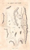
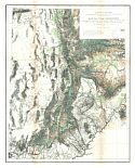
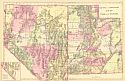
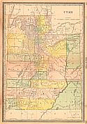
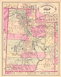
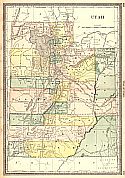
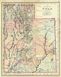
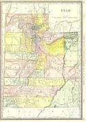
  Title/Description:   
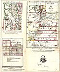
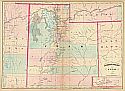
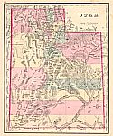
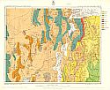
U.S. Geographical Surveys West of the One-Hundredth Meridian, Central and Western Utah - Atlas Sheet Number 50.
  Publication Info:   Washington: U.S. Department of the Interior, By Order of the Honorable the Secretary of War; Expeditions of 1872 and 1873 Under the Command of 1st Lieutenant Geo. M. Wheeler, Corps of Engineers, U.S. Army
  Date:   1874
  Scale:   1:507,000
  Original Source:   Courtesy of Murray Hudson, Halls, Tennessee
Viewing options:


  Main Author:   U.S. Geological Survey
  Title/Description:   Map of Utah Territory
  Publication Info:   Washington: Department of the Interior, U.S. Geological Survey, 1878
  Date:   1878
  Scale:   1:633,600
  Original Source:   Geological Survey of Alabama
Viewing options:


  Main Author:   Gamble, William H.
  Title/Description:   County Map of Utah and Nevada
  Publication Info:   Philadelphia: S.A. Mitchell, 1879
  Date:   1879
  Scale:   1:3,041,000
  Original Source:   Courtesy of Murray Hudson, Halls, Tennessee
Viewing options:


  Main Author:   Mitchell, Samuel A.
  Title/Description:   County and Township Map of Utah and Nevada
  Publication Info:   Philadelphia: S.A. Mitchell, 1880
  Date:   1880
  Scale:   1:1,837,000
  Original Source:   Courtesy of Murray Hudson, Halls, Tennessee
Viewing options:


  Main Author:   Bradley, William M.
  Title/Description:   County Map of Utah and Colorado
  Publication Info:   Philadelphia: William M.Bradley, c.1881
  Date:   1881
  Scale:   1:4,055,000
  Original Source:   Courtesy of Murray Hudson, Halls, Tennessee
Viewing options:


  Main Author:   Mitchell, Samuel A.
  Title/Description:   County and Township Map of Utah and Nevada
  Publication Info:   Philadelphia: S.A. Mitchell, 1881
  Date:   1881
  Scale:   1:1,774,000
  Original Source:   Courtesy of Murray Hudson, Halls, Tennessee
Viewing options:


  Main Author:   Hardesty, H.H.
  Title/Description:   Map of Utah
  Publication Info:   Chicago: H.H. Hardesty, 1882
  Date:   1882
  Scale:   1:1,426,000
  Original Source:   Courtesy of Murray Hudson, Halls, Tennessee
Viewing options:


  Main Author:   Cram, George F.
  Title/Description:   New Railroad and County Map of Utah
  Publication Info:   Chicago: George F. Cram, 1883
  Date:   1883
  Scale:   1:2,281,000
  Original Source:   Courtesy of Murray Hudson, Halls, Tennessee
Viewing options:


  Main Author:   Hardesty, H.H.
  Title/Description:   Map of Utah
  Publication Info:   New York: H.H. Hardesty and Company, 1883; from The Historical and Geographical Encyclopedia
  Date:   1883
  Scale:   1:1,394,000
  Original Source:   Courtesy of Murray Hudson, Halls, Tennessee
Viewing options:


  Main Author:   Gray, Ormando W.
  Title/Description:   Utah
  Publication Info:   Philadelphia: O.W. Gray and Son, 1883; from The National Atlas
  Date:   1883
  Scale:   1:1,584,000
  Original Source:   Courtesy of Murray Hudson, Halls, Tennessee
Viewing options:


  Main Author:   Rand McNally and Company
  Title/Description:   Utah
  Publication Info:   Chicago: Rand McNally and Company, 1884; from The Indexed Atlas of the World
  Date:   1884
  Scale:   1:1,394,000
  Original Source:   From the personal collection of Dr. Gerald Webster
Viewing options:


Next Page