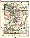
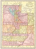
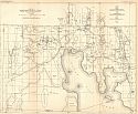
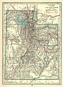
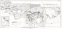
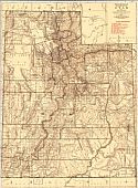
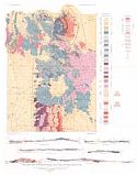
Historical Maps of Other Southeastern States

After 1900
Before 1885
1885-1900
After 1900

Previous Page

  Main Author:   Cram, George F.
  Title/Description:   Utah
  Publication Info:   Chicago: The Fort Dearborn Publishing Company, 1901; from The National Standard Family and Business Atlas of the World
  Date:   1901
  Scale:   1:2,280,960
  Original Source:   Courtesy of Murray Hudson, Halls, Tennessee
Viewing options:


  Main Author:   Rand McNally and Company
  Title/Description:   Utah
  Publication Info:   Chicago: Rand McNally and Company, 1901; from The Enlarged Business Atlas and Shippers Guide
  Date:   1901
  Scale:   1:1,457,280
  Original Source:   Courtesy of Murray Hudson, Halls, Tennessee
Viewing options:


  Main Author:   Rand McNally and Company
  Title/Description:   Utah
  Publication Info:   Chicago: Rand McNally and Company, 1901; from the Universal Atlas of the World
  Date:   1901
  Scale:   1:2,027,520
  Original Source:   Courtesy of Murray Hudson, Halls, Tennessee
Viewing options:


  Main Author:   Mast, Crowell and Kirkpatrick
  Title/Description:   Utah
  Publication Info:   Chicago: Benedict and Company, 1902; from The Peerless Atlas
  Date:   1902
  Scale:   1:2,344,000
  Original Source:   University of Alabama Map Library
Viewing options:


  Main Author:   The Century Company
  Title/Description:   Nevada and Utah
  Publication Info:   Buffalo: The Matthew-Northrup Company, 1902; from The Century Atlas
  Date:   1902
  Scale:   1:2,978,000
  Original Source:   From the personal collection of Dr. Robert Burckhalter
Viewing options:


  Main Author:   Cram, George F.
  Title/Description:   Map of Utah
  Publication Info:   Chicago: George F. Cram, 1903; from The Modern Atlas
  Date:   1903
  Scale:   1:1,393,920
  Original Source:   Courtesy of Murray Hudson, Halls, Tennessee
Viewing options:


  Main Author:   The Americana Company
  Title/Description:   Utah
  Publication Info:   New York: The Americana Company, 1904
  Date:   1904
  Scale:   1:2,408,000
  Original Source:   Courtesy of Murray Hudson, Halls, Tennessee
Viewing options:


  Main Author:   Miller, J. Martin
  Title/Description:   Utah
  Publication Info:   unknown, 1904; from The Twentieth Century Atlas and Illustrated World
  Date:   1904
  Scale:   1:1,837,440
  Original Source:   Courtesy of Murray Hudson, Halls, Tennessee
Viewing options:


  Main Author:   U.S. Geological Survey
  Title/Description:   Geologic Map of the Bingham Mining District, Utah
  Publication Info:   Washington: Department of the Interior, U.S. Geological Survey, 1904; from Professional Paper No. 38 Plate I
  Date:   1904
  Scale:   1:20,000
  Original Source:   Geological Survey of Alabama
Viewing options:


  Main Author:   U.S. Geological Survey
  Title/Description:   Map Showing Economic Geology of the Bingham Mining District, Utah
  Publication Info:   Washington: Department of the Interior, U.S. Geological Survey, 1904; from Professional Paper No. 38 Plate XVI
  Date:   1904
  Scale:   1:20,000
  Original Source:   Geological Survey of Alabama
Viewing options:


  Main Author:   Rand McNally and Company.
  Title/Description:   Utah
  Publication Info:   Chicago: Rand McNally and Company, 1905; from The Unrivaled Atlas of the World
  Date:   1905
  Scale:   1:2,027,520
  Original Source:   Courtesy of Murray Hudson, Halls, Tennessee
Viewing options:


  Main Author:   Rand McNally and Company
  Title/Description:   Utah
  Publication Info:   Chicago: Rand McNally and Company, 1906; from The Business Atlas and Shippers Guide
  Date:   1906
  Scale:   1:1,457,280
  Original Source:   Courtesy of Murray Hudson, Halls, Tennessee
Viewing options:


  Main Author:   Hammond, C.S.
  Title/Description:   Utah
  Publication Info:   New York: C.S. Hammond and Company, 1906; from The Pictorial Atlas of the World
  Date:   1906
  Scale:   1:2,407,680
  Original Source:   Courtesy of Murray Hudson, Halls, Tennessee
Viewing options:


  Main Author:    
  Title/Description:   Utah
  Publication Info:   Chicago: George F. Cram for A.A. Grant, Toronto, Ontario 1906; From Grant's Bankers and Brokers Railroad System Atlas
  Date:   1906
  Scale:   1:1,330,560
  Original Source:   Courtesy of Murray Hudson, Halls, Tennessee
Viewing options:


  Main Author:   Cram, George F.
  Title/Description:   Map of Utah
  Publication Info:   Chicago: George F. Cram, 1907; from The Standard American Atlas
  Date:   1907
  Scale:   1:1,393,920
  Original Source:   University of Alabama Map Library
Viewing options:


  Main Author:   P.F. Collier and Son
  Title/Description:   Utah
  Publication Info:   New York: P.F. Collier and Son, 1907; from The New Encyclopedic Atlas and Gazeteer of the World
  Date:   1907
  Scale:   1:2,217,600
  Original Source:   Courtesy of Murray Hudson, Halls, Tennessee
Viewing options:


  Main Author:   U.S. Geological Survey
  Title/Description:   Topographic Map of the Western Portion of the Uinta Mountains, Utah
  Publication Info:   Washington: Department of the Interior, U.S. Geological Survey, 1907; from Professional Paper No. 61 Plate IV
  Date:   1907
  Scale:   1:125,000
  Original Source:   Geological Survey of Alabama
Viewing options:


  Main Author:   U.S. Geological Survey
  Title/Description:   Topographic Map of Iron Springs Quadrangle, Utah
  Publication Info:   Washington: Department of the Interior, U.S. Geological Survey, 1907; from Bulletin 338 Plate I
  Date:   1907
  Scale:   1:62,500
  Original Source:   Geological Survey of Alabama
Viewing options:


  Main Author:   U.S. Geological Survey
  Title/Description:   Geologic Map and Sections of Iron Springs Quadrangle, Utah
  Publication Info:   Washington: Department of the Interior, U.S. Geological Survey, 1907; from Bulletin 338 Plate II
  Date:   1907
  Scale:   1:62,500
  Original Source:   Geological Survey of Alabama
Viewing options:


  Main Author:   U.S. Geological Survey
  Title/Description:   Geologic Reconnaissance Map of Sanpete and Central Sevier Valleys, Utah
  Publication Info:   Washington: Department of the Interior, U.S. Geological Survey, 1907; from Water Supply Paper No. 199 Plate 2
  Date:   1907
  Scale:   1:253,440
  Original Source:   Geological Survey of Alabama
Viewing options:


  Main Author:   The Crowell Publishing Company
  Title/Description:   Utah
  Publication Info:   New York: The Crowell Publishing Company, 1908; from The Twentieth Century Peerless Atlas
  Date:   1908
  Scale:   1:2,027,520
  Original Source:   Courtesy of Murray Hudson, Halls, Tennessee
Viewing options:


  Main Author:   U.S. Geological Survey
  Title/Description:   Reconnaissance Map and Cross Section of Part of the Rock Cliffs Coal Field, Colorado and Utah
  Publication Info:   Washington: Department of the Interior, U.S. Geological Survey, 1908; from Bulletin 371 Plate I
  Date:   1908
  Scale:   1:380,160
  Original Source:   Geological Survey of Alabama
Viewing options:


  Main Author:   Patten, William and J.E. Homas
  Title/Description:   Utah
  Publication Info:   New York: P.F. Collier and Son, 1909; from The New Encyclopedic Atlas and Gazetteer of the World
  Date:   1909
  Scale:   1:2,217,600
  Original Source:   University of Alabama Map Library
Viewing options:


  Main Author:   Cram, George F.
  Title/Description:   Utah
  Publication Info:   Chicago: George F. Cram, 1909; from The Art of Our Country
  Date:   1909
  Scale:   1:1,742,400
  Original Source:   Courtesy of Murray Hudson, Halls, Tennessee
Viewing options:


  Main Author:   U.S. Geological Survey
  Title/Description:   Reconnaissance Geologic and Topographic Map of Part of Jensen Quadrangle, Utah and Colorado
  Publication Info:   Washington: Department of the Interior, U.S. Geological Survey, 1908; from Bulletin 415 Plate XXI
  Date:   1908
  Scale:   1:125,000
  Original Source:   Geological Survey of Alabama
Viewing options:


  Main Author:   Rand McNally and Company
  Title/Description:   Rand McNally and Company's Utah
  Publication Info:   Chicago: Rand McNally and Company, 1910
  Date:   1910
  Scale:   1:1,457,280
  Original Source:   Courtesy of Murray Hudson, Halls, Tennessee
Viewing options:


  Main Author:   Hammond, C.S.
  Title/Description:   Utah
  Publication Info:   New York: C.S. Hammond and Company, 1911; from The Modern Atlas of the World
  Date:   1911
  Scale:   1:2,407,680
  Original Source:   Courtesy of Murray Hudson, Halls, Tennessee
Viewing options:


  Main Author:   U.S. Geological Survey
  Title/Description:   Topographic Map of Juab and Millard Counties, Utah, Showing Areas of Flowing Wells
  Publication Info:   Washington: Department of the Interior, U.S. Geological Survey, 1911; from Water Supply Paper No. 277 Plate I
  Date:   1911
  Scale:   1:1,000,000
  Original Source:   Geological Survey of Alabama
Viewing options:


  Main Author:   U.S. Geological Survey
  Title/Description:   Topographic Map of Fishing Springs Quadrangle, Utah
  Publication Info:   Washington: Department of the Interior, U.S. Geological Survey, 1911; from Water Supply Paper No. 277 Plate 4
  Date:   1911
  Scale:   1:250,000
  Original Source:   Geological Survey of Alabama
Viewing options:


  Main Author:   Rand McNally and Company
  Title/Description:   Utah
  Publication Info:   Chicago: Rand McNally and Company; from The Rand McNally Imperial Atlas of the World
  Date:   1912
  Scale:   1:2,027,520
  Original Source:   Courtesy of Murray Hudson, Halls, Tennessee
Viewing options:


  Main Author:   U.S. Geological Survey
  Title/Description:   Map of Utah, Showing Location of Mining Districts
  Publication Info:   Washington: Department of the Interior, U.S. Geological Survey, 1912; from Bulletin 507 Plate XIV
  Date:   1912
  Scale:   1:2,500,000
  Original Source:   Geological Survey of Alabama
Viewing options:


  Main Author:   Rand McNally and Company
  Title/Description:   New Commercial Atlas Map of Utah
  Publication Info:   Chicago: Rand McNally and Company, 1913
  Date:   1913
  Scale:   1:950,400
  Original Source:   Courtesy of Murray Hudson, Halls, Tennessee
Viewing options:


  Main Author:   Cram, George F.
  Title/Description:   Utah
  Publication Info:   Chicago: George F. Cram, 1913; from Cram's Unrivaled Atlas of the World
  Date:   1913
  Scale:   1:1,774,080
  Original Source:   Courtesy of Murray Hudson, Halls, Tennessee
Viewing options:


  Main Author:   U.S. Geological Survey
  Title/Description:   Geologic Map and Sections of the Mining Districts of the San Francisco Region, Utah
  Publication Info:   Washington: Department of the Interior, U.S. Geological Survey, 1913; from Professional Paper No. 80 Plate I
  Date:   1913
  Scale:   1:62,500
  Original Source:   Geological Survey of Alabama
Viewing options:


  Main Author:   U.S. Geological Survey
  Title/Description:   Map of Boxelder County, Utah showing location of wells and springs
  Publication Info:   Washington: Department of the Interior, U.S. Geological Survey, 1913; from Water Supply Paper No. 333 Plate I
  Date:   1913
  Scale:   1:375,000
  Original Source:   Geological Survey of Alabama
Viewing options:


  Main Author:   U.S. Geological Survey
  Title/Description:   Topographic Map of Utah showing water-powered plants, transmission lines, undeveloped power possibilities and mining districts
  Publication Info:   Washington: Department of the Interior, U.S. Geological Survey, 1918; from Professional Paper No. 111 Plate I
  Date:   1918
  Scale:   1:750,000
  Original Source:   Geological Survey of Alabama
Viewing options:


  Main Author:   Reynolds, Francis J.
  Title/Description:   Utah
  Publication Info:   New York: P.F.Collier and Son, 1914; from the Encyclopedic Atlas and Gazetteer of the World
  Date:   1914
  Scale:   1:2,217,600
  Original Source:   Courtesy of Murray Hudson, Halls, Tennessee
Viewing options:


  Main Author:   unknown
  Title/Description:   Salt Lake City
  Publication Info:   Salt Lake City: c.1915
  Date:   1915
  Scale:   oblique view
  Original Source:   Courtesy of Murray Hudson, Halls, Tennessee
Viewing options:


  Main Author:   U.S. Geological Survey
  Title/Description:   Map of the Coalville Coal Field, Utah
  Publication Info:   Washington: Department of the Interior, U.S. Geological Survey, 1915; from Bulletin 581 Plate XI
  Date:   1915
  Scale:   1:62,500
  Original Source:   Geological Survey of Alabama
Viewing options:


  Main Author:   U.S. Geological Survey
  Title/Description:   Geologic Reconnaissace Map of the Cottonwood-American Fork Mining Region, Utah
  Publication Info:   Washington: Department of the Interior, U.S. Geological Survey, 1915; from Bulletin 620 Plate VI
  Date:   1915
  Scale:   1:50,000
  Original Source:   Geological Survey of Alabama
Viewing options:


  Main Author:   Rand McNally and Company
  Title/Description:   Utah
  Publication Info:   Chicago: Rand McNally and Company, 1916; from The Ideal Atlas of the World
  Date:   1916
  Scale:   1:2,027,520
  Original Source:   Courtesy of Murray Hudson, Halls, Tennessee
Viewing options:


  Main Author:   U.S. Geological Survey
  Title/Description:   Map of Emery Coal Field, Emery and Sevier Counties, Utah
  Publication Info:   Washington: Department of the Interior, U.S. Geological Survey, 1916; from Bulletin 628 Plate X
  Date:   1916
  Scale:   1:62,500
  Original Source:   Geological Survey of Alabama
Viewing options:


  Main Author:   Hammond, C.S.
  Title/Description:   Utah
  Publication Info:   New York: C.S. Hammond and Company, 1917; from The New Universal Atlas of the World
  Date:   1917
  Scale:   1:2,407,680
  Original Source:   Courtesy of Murray Hudson, Halls, Tennessee
Viewing options:


  Main Author:   U.S. Geological Survey
  Title/Description:   Map of Ozokerite Field in Central Utah
  Publication Info:   Washington: Department of the Interior, U.S. Geological Survey, 1917; Bulletin 641 Plate 1
  Date:   1917
  Scale:   1:31,680
  Original Source:   Geological Survey of Alabama
Viewing options:


  Main Author:   U.S. Geological Survey
  Title/Description:   Topographic Map of Utah showing water-powered plants, transmission lines, undeveloped power possibilities and mining districts
  Publication Info:   Washington: Department of the Interior, U.S. Geological Survey, 1918; from Professional Paper No. 111 Plate I
  Date:   1918
  Scale:   1:750,000
  Original Source:   Geological Survey of Alabama
Viewing options:


  Main Author:   U.S. Geological Survey
  Title/Description:   Geologic Map and Sections of the Bingham Mining District, Utah
  Publication Info:   Washington: Department of the Interior, U.S. Geological Survey, 1918; from Professional Paper No. 38 Plate XXXIII
  Date:   1918
  Scale:   1:20,000
  Original Source:   Geological Survey of Alabama
Viewing options:


  Main Author:   U.S. Geological Survey
  Title/Description:   Geologic Map of the Cottonwood and Park City Mining Districts, Utah
  Publication Info:   Washington: Department of the Interior, U.S. Geological Survey, 1918; from Professional Paper No. 111Plate XXVII
  Date:   1918
  Scale:   1:25,000
  Original Source:   Geological Survey of Alabama
Viewing options:


  Main Author:   U.S. Geological Survey
  Title/Description:   Reconnaissance Geologic Map of Utah
  Publication Info:   Washington: Department of the Interior, U.S. Geological Survey, 1918; from Professional Paper No. 111 Plate IV
  Date:   1918
  Scale:   1:750,000
  Original Source:   Geological Survey of Alabama
Viewing options:


  Main Author:   U.S. Geological Survey
  Title/Description:   Map Showing Distribution of Oil Shale in Uinta Basin, Utah
  Publication Info:   Washington: Department of the Interior, U.S. Geological Survey, 1918; from Bulletin 691 Plate XII
  Date:   1918
  Scale:   1:62,500
  Original Source:   Geological Survey of Alabama
Viewing options:


  Main Author:   U.S. Geological Survey
  Title/Description:   Map Showing the Distribution of Phosphate Deposits Along the North and South Slopes of Uinta Mountains, in Northeastern Utah
  Publication Info:   Washington: Department of the Interior, U.S. Geological Survey, 1915; from Bulletin 690 Plate V
  Date:   1918
  Scale:   1:500,000
  Original Source:   Geological Survey of Alabama
Viewing options:


  Main Author:   Reynolds, Francis J.
  Title/Description:   Utah
  Publication Info:   New York: P.F. Collier and Son Company, 1920; from The New World Atlas and Gazetteer
  Date:   1920
  Scale:   1:2,280,960
  Original Source:   Courtesy of Murray Hudson, Halls, Tennessee
Viewing options:


  Main Author:   Cram, George F.
  Title/Description:   Utah
  Publication Info:   Chicago: James R. Gray and Company, 1920; from Cram's Unrivaled Atlas of the World
  Date:   1920
  Scale:   1:1,837,440
  Original Source:   Courtesy of Murray Hudson, Halls, Tennessee
Viewing options:


  Main Author:   Rand McNally and Company
  Title/Description:   Utah and Colorado- Black and White Mileage Map
  Publication Info:   Chicago: Rand McNally and Company; from The Commercial Atlas of America
  Date:   1921
  Scale:   1:2,217,600
  Original Source:   University of Alabama Map Library
Viewing options:


  Main Author:   Rand McNally and Company
  Title/Description:   Utah
  Publication Info:   Chicago: Rand McNally and Company; from The Commerical Atlas of America
  Date:   1921
  Scale:   1:950,400
  Original Source:   University of Alabama Map Library
Viewing options:


  Main Author:   C.S. Hammond and Company
  Title/Description:   Utah
  Publication Info:   New York: C.S. Hammond and Company, 1922; from the New World Loose Leaf Atlas
  Date:   1922
  Scale:   1:2,407,680
  Original Source:   Courtesy of Murray Hudson, Halls, Tennessee
Viewing options:


  Main Author:   U.S. Geological Survey
  Title/Description:   Map Showing distribution of Oil Shale in Uinta Basin, Utah
  Publication Info:   Washington: Department of the Interior, U.S. Geological Survey, 1922; Bulletin 729 Plate 16
  Date:   1922
  Scale:   1:250,000
  Original Source:   Geological Survey of Alabama
Viewing options:


  Main Author:   U.S. Geological Survey
  Title/Description:   Geologic Map of the San Juan Canyon and Adjacent Country, in Southeastern Utah
  Publication Info:   Washington: Department of the Interior, U.S. Geological Survey, 1924; Bulletin 751 Plate 15
  Date:   1924
  Scale:   1:125,000
  Original Source:   Geological Survey of Alabama
Viewing options:


  Main Author:   U.S. Geological Survey
  Title/Description:   Map of Eastern Portion of Great Salt Lake Basin showing the development of water power
  Publication Info:   Washington: Department of the Interior, U.S. Geological Survey, 1924; from Water Supply Paper No. 517 Plate III
  Date:   1924
  Scale:   1:500,000
  Original Source:   Geological Survey of Alabama
Viewing options:


  Main Author:   U.S. Geological Survey
  Title/Description:   Geologic Map and Sections of the Castlegate, Wellington, and Sunnyside Quadrangle, Utah
  Publication Info:   Washington: Department of the Interior, U.S. Geological Survey, 1928; Bulletin 793 Plate 22
  Date:   1928
  Scale:   1:62,500
  Original Source:   Geological Survey of Alabama
Viewing options:


  Main Author:   U.S. Geological Survey
  Title/Description:   Map of Part of the San Rafael Swell, Utah
  Publication Info:   Washington: Department of the Interior, U.S. Geological Survey, 1928; Bulletin 806 Plate 30
  Date:   1928
  Scale:   1:126,720
  Original Source:   Geological Survey of Alabama
Viewing options:


  Main Author:   U.S. Geological Survey
  Title/Description:   Map of Southern Extension of Wasatch Plateau Coal Field South of Ivie Creek, Seivier County, Utah
  Publication Info:   Washington: Department of the Interior, U.S. Geological Survey, 1931; Bulletin 819 Plate 33
  Date:   1931
  Scale:   1:62,500
  Original Source:   Geological Survey of Alabama
Viewing options:


  Main Author:   U.S. Geological Survey
  Title/Description:   Geologic Map and Sections of the Southern Part of the Wasatch Plateau Coal Field, Utah
  Publication Info:   Washington: Department of the Interior, U.S. Geological Survey, 1931; Bulletin 819 Plate 32
  Date:   1931
  Scale:   1:62,500
  Original Source:   Geological Survey of Alabama
Viewing options:


  Main Author:   U.S. Geological Survey
  Title/Description:   Geologic Map and Sections of the Northern Part of the Wasatch Plateau Coal Field, Utah
  Publication Info:   Washington: Department of the Interior, U.S. Geological Survey, 1931; Bulletin 819 Plate 31
  Date:   1931
  Scale:   1:62,500
  Original Source:   Geological Survey of Alabama
Viewing options:


  Main Author:   U.S. Geological Survey
  Title/Description:   Topographic Map of Kaiparowits Region, Utah-Arizona
  Publication Info:   Washington: Department of the Interior, U.S. Geological Survey, 1931; Professional Paper 164, Plate 1
  Date:   1931
  Scale:   1:250,000
  Original Source:   Geological Survey of Alabama
Viewing options:


  Main Author:   U.S. Geological Survey
  Title/Description:   Geologic Map of Kaiparowits Region, Utah-Arizona
  Publication Info:   Washington: Department of the Interior, U.S. Geological Survey, 1931; Professional Paper 164, Plate 2
  Date:   1931
  Scale:   1:250,000
  Original Source:   Geological Survey of Alabama
Viewing options:


  Main Author:   U.S. Geological Survey
  Title/Description:   Geologic Map and Sections of the Stockton and Fairfield Quadrangles, Utah
  Publication Info:   Washington D.C.: Department of the Interior, U.S. Geological Survey, 1932; Professional Paper 173, Plate 12
  Date:   1932
  Scale:   1:62,500
  Original Source:   Geological Survey of Alabama
Viewing options:


  Main Author:   U.S. Geological Survey
  Title/Description:   Map of Escalante Valley, Utah showing topography hydrology, and land classification
  Publication Info:   Washington: Department of the Interior, U.S. Geological Survey, 1932; from Water Supply Paper No. 659 Plate I
  Date:   1932
  Scale:   1:250,000
  Original Source:   Geological Survey of Alabama
Viewing options:


  Main Author:   U.S. Geological Survey
  Title/Description:   Map Showing Geologic Structure of Moab District, Utah
  Publication Info:   Washington: Department of the Interior, U.S. Geological Survey, 1933; Bulletin 841, Plate 2
  Date:   1933
  Scale:   1:62,500
  Original Source:   Geological Survey of Alabama
Viewing options:


  Main Author:   U.S. Geological Survey
  Title/Description:   Geologic Map of Moab District, Utah
  Publication Info:   Washington: Department of the Interior, U.S. Geological Survey, 1933; Bulletin 841, Plate 1
  Date:   1933
  Scale:   1:62,500
  Original Source:   Geological Survey of Alabama
Viewing options:


  Main Author:   U.S. Geological Survey
  Title/Description:   Geologic Map and Sections of Monument Valley - Navajo Mountain Region, San Juan County, Utah
  Publication Info:   Washington: Department of the Interior, U.S. Geological Survey, 1935; Bulletin 865, Plate 1
  Date:   1935
  Scale:   1:96,000
  Original Source:   Geological Survey of Alabama
Viewing options:


  Main Author:   U.S. Geological Survey
  Title/Description:   Reconnaissance Topographic Map of Monument Valley - Navajo Mountain Region, San Juan County, Utah
  Publication Info:   Washington: Department of the Interior, U.S. Geological Survey, 1935; Bulletin 865, Plate 2
  Date:   1935
  Scale:   1:125,000
  Original Source:   Geological Survey of Alabama
Viewing options:


  Main Author:   U.S. Geological Survey
  Title/Description:   Geologic Map of the Salt Valley Anticline and the Adjacent areas, Grand County, Utah
  Publication Info:   Washington: Department of the Interior, U.S. Geological Survey, 1935; Bulletin 863, Plate 1
  Date:   1935
  Scale:   1:62,500
  Original Source:   Geological Survey of Alabama
Viewing options:


  Main Author:   U.S. Geological Survey
  Title/Description:   Map and Section of the West-Central Part of the Book Cliff Coal Field, Emery and Grand Counties, Utah, Showing Geology and Structure
  Publication Info:   Washington: Department of the Interior, U.S. Geological Survey, 1935; Bulletin 852, Plate 9
  Date:   1935
  Scale:   1:63,360
  Original Source:   Geological Survey of Alabama
Viewing options:


  Main Author:   U.S. Geological Survey
  Title/Description:   Map of the Northwestern Part of the Book Cliffs Coal Field, Emery and Carbon Counties, Utah, Showing Geology and Structure
  Publication Info:   Washington: Department of the Interior, U.S. Geological Survey, 1935; Bulletin 852, Plate 8
  Date:   1935
  Scale:   1:63,360
  Original Source:   Geological Survey of Alabama
Viewing options:


  Main Author:   U.S. Geological Survey
  Title/Description:   Map of the East-Central Part of the Book Cliff Coal Field, Grand County, Utah, Showing Geology and Structure
  Publication Info:   Washington: Department of the Interior, U.S. Geological Survey, 1935; Bulletin 852, Plate 10
  Date:   1935
  Scale:   1:63,360
  Original Source:   Geological Survey of Alabama
Viewing options:


  Main Author:   U.S. Geological Survey
  Title/Description:   Map of the Northeastern Part of Book Cliffs Coal Field, Grand County, Utah, Showing Geology and Structure
  Publication Info:   Washington: Department of the Interior, U.S. Geological Survey, 1935; Bulletin 852, Plate 11
  Date:   1935
  Scale:   1:63,360
  Original Source:   Geological Survey of Alabama
Viewing options:


  Main Author:   U.S. Geological Survey
  Title/Description:   Geologic Map and Structure Sections of Gold Hill and Vicinity, Utah
  Publication Info:   Washington: Department of the Interior, U.S. Geological Survey, 1935; Professional Paper 177, Plate 2
  Date:   1935
  Scale:   1:24,000
  Original Source:   Geological Survey of Alabama
Viewing options:


  Main Author:   U.S. Geological Survey
  Title/Description:   Geologic Map and Sections of Gold Hill Quadrangle, Utah
  Publication Info:   Washington: Department of the Interior, U.S. Geological Survey, 1935; Professional Paper 177, Plate 1
  Date:   1935
  Scale:   1:62,500
  Original Source:   Geological Survey of Alabama
Viewing options:


  Main Author:   U.S. Geological Survey
  Title/Description:   Geologic Map of the Areas Between Green and Colorado Rivers, Grand and San Juan Counties, Utah
  Publication Info:   Washington: Department of the Interior, U.S. Geological Survey, 1940; Bulletin 908, Plate 1
  Date:   1940
  Scale:   1:62,500
  Original Source:   Geological Survey of Alabama
Viewing options:


  Main Author:   U.S. Geological Survey
  Title/Description:   State of Utah
  Publication Info:   Washington: Department of the Interior, U.S. Geological Survey, 1940; compiled 1921 and 1922
  Date:   1940
  Scale:   1:1,000,000
  Original Source:   W. S. Hoole Special Collections Library
Viewing options:


  Main Author:   U.S. Coast and Geodetic Survey
  Title/Description:   Grand Junction Sectional Aeronautical Chart
  Publication Info:   Washington: U.S. Coast and Geodetic Survey, 1941
  Date:   1941
  Scale:   1:500,000
  Original Source:   Courtesy of Murray Hudson, Halls, Tennessee
Viewing options:


  Main Author:   U.S. Geological Survey
  Title/Description:   Relief Map of Utah
  Publication Info:   Salt Lake City: The State of Utah, Department of Publicity and Industrial Development, 1947
  Date:   1947
  Scale:   1:1,000,000
  Original Source:   Geological Survey of Alabama
Viewing options:


  Main Author:   U.S. Geological Survey
  Title/Description:   Map Showing the Distribution of Manganese Deposits in Western Utah
  Publication Info:   Washington: Department of the Interior, U.S. Geological Survey, 1950; Professional Paper 979, Plate 1
  Date:   1950
  Scale:   1:1,000,000
  Original Source:   Geological Survey of Alabama
Viewing options:


  Main Author:   U.S. Geological Survey
  Title/Description:   Geologic Map of the Henry Mountains region, Utah
  Publication Info:   Washington: Department of the Interior, U.S. Geological Survey, 1953; Professional Paper 228, Plate 1
  Date:   1953
  Scale:   1:125,000
  Original Source:   Geological Survey of Alabama
Viewing options:


  Main Author:   Hintze, Lehi F.
  Title/Description:   Geologic Map of Utah
  Publication Info:   Salt Lake City: Utah Geological and Mineral Survey, 1980
  Date:   1980
  Scale:   1:500,000
  Original Source:   Geological Survey of Alabama
Viewing options:
 

Previous Page