Use the menu to the right to browse our collection of out-of-print editions of U.S.G.S. Quadrangles. Please keep in mind that map coverage varies and may not be complete for all counties.
Out-of-Print Quadrangles
Main Author
Alabama Highway Dept.
Alabama Highway Dept.
Alabama Highway Dept.
Alabama Highway Dept.
Alabama Highway Dept.
Alabama Highway Dept.
Alabama Highway Dept.
Alabama Highway Dept.
Alabama Highway Dept.
Alabama Highway Dept.
Alabama Highway Dept.
Alabama Highway Dept.
Alabama Highway Dept.
Location
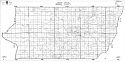
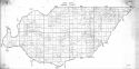
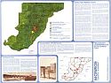
Monroe County
Monroe County (N)
Monroe County (S)
Monroe County (N)
Monroe County (S)
Monroe County (N)
Monroe County (S)
Monroe County (N)
Monroe County (S)
Monroe County (N)
Monroe County (S)
Monroe County
Monroe County
Publication Information
Montgomery: ASHD
Montgomery: ASHD
Montgomery: ASHD
Montgomery: ASHD
Montgomery: ASHD
Montgomery: ASHD
Montgomery: ASHD
Montgomery: ASHD
Montgomery: ASHD
Montgomery: ASHD
Montgomery: ASHD
Montgomery: ASHD
Montgomery: ASHD
Date
2007
1997
1997
1989
1989
1980
1980
1969
1969
1951
1951
1938
1937
Scale
1:125,000
1:125,000
1:125,000
1:125,000
1:125,000
1:125,000
1:125,000
1:125,000
1:125,000
1:125,000
1:125,000
1:125,000
1:125,000
Viewing Options
Main Author:
LaTourrette, John
Title/Description:
An Accurate Map of the State of Alabama and West Florida [Sheet 20: Clarke, Conecuh, Dallas, Marengo, Monroe, Wilcox]
Publication Info:
New York: Colton & Co., 1837

Viewing Options
Title/Description:
Claiborne, Alabama
Publication Info:
1906 tracing of the 1819 Survey of Claiborne by John Coffee
Viewing Options
Viewing Options
Main Author:
U.S. Department of Agriculture
Title/Description:
Monroe County soil survey map
Publication Info:
Washington: U.S. Department of Agriculture
Viewing Options
Main Author:
U.S. Department of Agriculture
Title/Description:
Monroe County soil survey map
Publication Info:
Washington: U.S. Department of Agriculture, 1916
Viewing Options
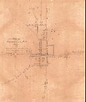
Title/Description:
Map of Monroeville, Alabama, 1922
Publication Info:
hand drawn

Viewing Options
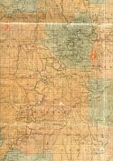
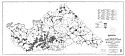
Main Author:
Alabama State Board of Health
Title/Description:
Map of Monroe County, Alabama
Publication Info:
Alabama State Board of Health, c.1935; hand annotated with historic features
Viewing Options
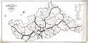
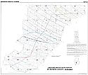
Main Author:
Alabama State Highway Department
Title/Description:
Traffic Flow Map, Monroe County, Alabama
Publication Info:
Montgomery: Alabama State Highway Department, 1938
Viewing Options
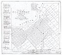
Main Author:
Coffee, John
Title/Description:
The Town of Claiborne as Planned by John Coffee and Surveyed by Messrs, Lawson & Henshaw in 1819
Publication Info:
Monroeville: Hand-drawn reproduction by Rumbley, T.A., of 1819 map, 1943
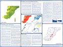
Northern Section
Central Section
Southern Section
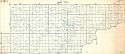
Title/Description:
Monroe County
Publication Info:
Shreveport: Globe Map Company, 1950
Original Source:
Courtesy of Thomas E. McMillan Museum, Brewton, Alabama
Viewing Options
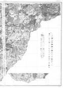
Main Author:
Ivey, John B.
Title/Description:
Geologic Map of Monroeville and Vicinity, Alabama
Publication Info:
Tuscaloosa, Geological Survey of Alabama, 1957; Bulletin 66 Plate I, map dated 1952 published in 1957 bulletin
Viewing Options
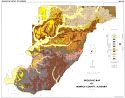
Main Author:
Clarke, O.M. Jr., T.W. Daniel Jr., M.W. Szabo and D.H. White
Title/Description:
Mineral Resources Map of Monroe County, Alabama
Publication Info:
Geological Survey of Alabama, Special Map 90
Viewing Options
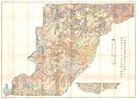
Main Author:
Scott, John C.
Title/Description:
Geologic Map of Monroe County, Alabama
Publication Info:
Geological Survey of Alabama, Special Map 101
Viewing Options
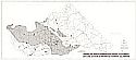
Main Author:
Alabama-Tombigbee Rivers Regional Planning & Development Commission
Title/Description:
Monroe County, AL- Existing Land Use Map
Publication Info:
Montgomery: Alabama-Tombigbee Rivers Regional Planning & Development Commission, 1971
Viewing Options
Main Author:
Scott, John C., Marvin E. Davis, Jerald F. McCain and Harry M. Whitman
Title/Description:
Ground Water Availability of Monroe County, Alabama
Publication Info:
Tuscaloosa: Geological Survey of Alabama, 1972; Map 132
Viewing Options
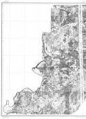
Main Author:
U.S. Department of the Interior, U.S. Geological Survey
Title/Description:
Areas in which sinkholes have occurred or can occur in Monroe County, Alabama
Publication Info:
United States Department of the Interior, U.S. Geological Survey, 1977
Viewing Options
Viewing Options
Main Author:
Alabama-Tombigbee Regional Commission
Title/Description:
Monroe County, Alabama, Preliminary Comprehensive Development Plan
Publication Info:
The Commission: 1977

