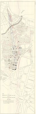
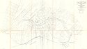
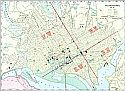
Viewing Options
Main Author:
U.S. Army Corps of Engineers
Title/Description:
[Extentions of Connecticut Avenue]
Publication Info:
Washington: U.S. House of Representatives 54th Congress, 2nd Session, Doc. No. 53, 1896
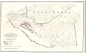
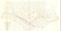
Viewing Options
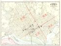
Main Author:
U.S. Army Corp of Engineers
Title/Description:
Map showing portion of Washington D.C. between distributing reservoir and new reservoir
Publication Info:
Washington: U.S. House of Representatives, 54th Congress, 1st Session, Doc. No. 166, 1896
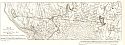
Viewing Options
Main Author:
U.S. Army Corps of Engineers
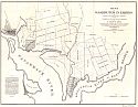
Title/Description:
Chart of the Head of Navigation of the Potomac River with a view to the improvement of the Georgetown Canal, 1857
Publication Info:
Washington: U.S. House of Representatives, 54th Congress, 1st Session, Doc. No. 296, 1896
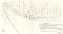
Viewing Options
Main Author:
U.S. Army Corps of Engineers
Title/Description:
Plat of (Potomac) River Front from 27th Street West to 17th Street West
Publication Info:
Washington: U.S. House of Representatives, 54th Congress, 1st Session, Doc. No. 296, 1896
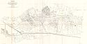
Viewing Options
Main Author:
U.S. Army Corps of Engineers
Title/Description:
Sketch of Washington in Embryo
Publication Info:
Washington: U.S. House of Representatives, 54th Congress, 1st Session, Doc. No. 296, 1896
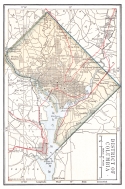
Viewing Options
Main Author:
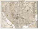
D. Appleton and Company
Title/Description:
Washington D.C.
Publication Info:
New York: D. Appleton and Company, 1896; from Appleton's General Guide to the United States and Canada
Viewing Options
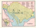
Main Author:
Rand McNally and Company
Title/Description:
Washington D.C.
Publication Info:
Chicago: Rand McNally and Company, 1896; from Enlarged Business Atlas

Viewing Options
Main Author:
/U.S. Geological Survey
Title/Description:
Washington and Vicinity
Publication Info:
Washington: U.S. Department of the Interior, Geological Survey, 1898
Viewing Options
Main Author:
Cram, George F.
Title/Description:
Washington D.C.
Publication Info:
Chicago: George F. Cram, 1898 from Cram's Universal Atlas, Geographical, Astronomical and Historical
Viewing Options
Main Author:
U.S. Army Corps of Engineers
Title/Description:
Map of Anacostia River in the District of Columbia, Sheet 1, from the Mouth to Navy Yard Bridge
Publication Info:
Washington: U.S. House of Representatives, 55th Congress, 3rd Session, Doc. No. 87, 1898
Viewing Options
Main Author:
U.S. Army Corps of Engineers
Title/Description:
Map of Anacostia River in the District of Columbia, Sheet 2, from Navy Yard Bridge to Bennings Bridge
Publication Info:
Washington: U.S. House of Representatives, 55th Congress, 3rd Session, Doc. No. 87

Viewing Options
Main Author:
U.S. Army Corps of Engineers
Title/Description:
Map of Anacostia River in the District of Columbia, from Bennings Bridge to the District Line
Publication Info:
Washington: U.S. House of Representatives, 55th Congress, 3rd Session, Doc. No. 87, 1898
Viewing Options
Main Author:
U.S. Army Corps of Engineers
Title/Description:
Index Map of Land Near Anacostia River, D.C. between District Line and Baltimore and Potomac R.R.
Publication Info:
Washington: U.S. House of Representatives, 55th Congress, 3rd Session, Doc. No. 87, 1898
Viewing Options
Main Author:
The Bradstreet Company
Title/Description:
District of Columbia
Publication Info:
New York: The Bradstreet Company, 1899; from Bradstreet's Pocket Atlas of the United States

Viewing Options
Main Author:
U.S. Geological Survey
Title/Description:
Washington Quadrangle
Publication Info:
Washington: The Department of the Interior, U.S. Geological Survey, 1900
Viewing Options
Main Author:
Rand McNally & Company
Title/Description:
Washington D.C.
Publication Info:
Chicago: Rand McNally & Company, 1900

Viewing Options
Main Author:
U.S. Geological Survey
Title/Description:
Historical Geology Sheet, Washington Quadrangle, Maryland - District of Columbia - Virginia
Publication Info:
Washington: U.S. Department of the Interior, U.S. Geological Survey, 1900