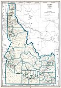
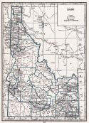
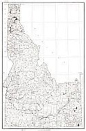
Viewing Options
Main Author:
Geographical Publishing Company
Publication Info:
Chicago: Geographical Publishing Company, 1931; from Commercial Atlas of the World
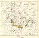
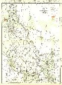
Viewing Options
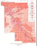
Main Author:
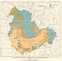
U.S. Geological Survey
Title/Description:
Map showing water Utilization in Snake River Basin
Publication Info:
Washington: Department of the Interior, U.S. Geological Survey, 1934; Water Supply Paper No. 657 Plate 1
Viewing Options
Main Author:
U.S. Geological Survey
Title/Description:
Map showing altitudes above sea level in Snake River Basin
Publication Info:
Washington: Department of the Interior, U.S. Geological Survey, 1934; Water Supply Paper No. 657 Plate 2
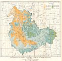
Viewing Options
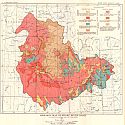
Main Author:
U.S. Geological Survey
Title/Description:
Map showing precipitation in Snake River Basin
Publication Info:
Washington: Department of the Interior, U.S. Geological Survey, 1934; Water Supply Paper No. 657 Plate 3
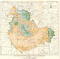
Viewing Options
Main Author:
U.S. Geological Survey
Title/Description:
Map showing Natural Vegetation in Snake River Basin
Publication Info:
Washington: Department of the Interior, U.S. Geological Survey, 1934; Water Supply Paper No. 657 Plate 4
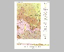
Viewing Options
Main Author:
U.S. Geological Survey
Title/Description:
Geologic Map of Snake River Basin
Publication Info:
Washington: Department of the Interior, U.S. Geological Survey, 1934; Water Supply Paper No. 657 Plate 5
Viewing Options
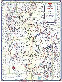
Main Author:
Continental Oil Company
Title/Description:
Official Road Map of Idaho
Publication Info:
Chicago: H.M. Gousha Company, c. 1934
Original Source:
Murray Hudson
Viewing Options
Main Author:
U.S. Geological Survey
Title/Description:
Geological Map and Sections of the Casto Quadrangle, Idaho
Publication Info:
Washing: Department of the Interior, U.S. Geological Survey, 1935; Bulletin 854 Plate 1
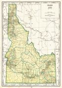
Viewing Options
Main Author:
Branom, Frederick K. and Lloyd Edwin Smith
Publication Info:
Chicago: Geographical Publishing Company, 1936; from Capper's 1936 Atlas of the World
Viewing Options
Main Author:
Rand McNally and Company
Title/Description:
Standard Map of Idaho
Publication Info:
Chicago: Rand McNally and Company, 1936
Viewing Options
Main Author:
Ross, Clyde P. and Thomas H. Hite Jr.
Title/Description:
Geologic Map and Structure sections for the Bayhorse Region, Idaho
Publication Info:
Washington, D.C: Department of the Interior, US Geological Survey, 1937; Bulletin 877, Plate 1
Viewing Options
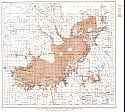
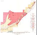
Main Author:
U.S. Geological Survey
Title/Description:
Map of the Snake River Plain Showing Depths to Ground Water
Publication Info:
Washington: Department of the Interior, U.S. Geological Survey, 1938; Water Supply Paper No. 774 Plate 18
Viewing Options
Main Author:
U.S. Geological Survey
Title/Description:
Craters of the Moon National Monument, Idaho
Publication Info:
Washington: Department of the Interior, U.S. Geological Survey, 1938; Water Supply Paper No. 774 Plate 13
Viewing Options
Main Author:
U.S. Geological Survey
Title/Description:
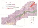
Geologic Map of the Canyon of the Snake River between American Falls and Steele Island, Power County, Idaho
Publication Info:
Washington: Department of the Interior, U.S. Geological Survey, 1938; Water Supply Paper No. 774 Plate 6
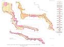
Viewing Options
Main Author:
U.S. Geological Survey
Title/Description:
Geologic Map of the Canyon of the Snake River from Twin Falls to King Hill, Idaho
Publication Info:
Washington: Department of the Interior, U.S. Geological Survey, 1938; Water Supply Paper No. 774 Plate 5
Viewing Options
Main Author:
U.S. Geological Survey
Title/Description:
Geological Map of the Snake River Plain East of King Hill, Idaho
Publication Info:
Washington: Department of the Interior, U.S. Geological Survey, 1938; Water Supply Paper No. 774 Plate 4
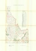
Viewing Options
Main Author:
U.S. Geological Survey
Title/Description:
State of Idaho
Publication Info:
Washington D.C.: Department of the Interior, U.S. Geological Survey, 1940; compiled 1916, revised 1926
Viewing Options
Main Author:
Geographical Publishing Company
Publication Info:
Chicago: Geographical Publishing Company, 1942; from The New International Atlas of the World, War Edition
Viewing Options
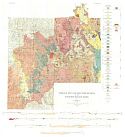
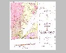
Main Author:
Bureau of the Census
Title/Description:
Idaho Irrigation by Drainage Basins, 1939
Publication Info:
Washington: U.S. Government Printing Office, 1942
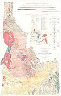
Viewing Options
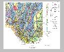
Main Author:
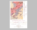
U.S. Geological Survey
Title/Description:
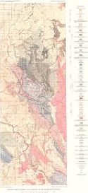
Geologic Map of the State of Idaho
Publication Info:
Washington: Department of the Interior, U.S. Geological Survey, 1947
Viewing Options
Main Author:
U.S. Geological Survey
Title/Description:
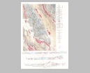
Geologic map and sections of the Quartzburg-Grimes Pass area, Idaho
Publication Info:
Washington, D.C: Department of the Interior, US Geological Survey, 1948; Bulletin 944, Plate 14
Viewing Options
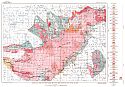
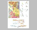
Main Author:
U.S. Geological Survey
Title/Description:
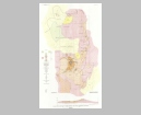
Geologic Map of Ammon and Paradise Valley Quadrangles, Idaho
Publication Info:
Washington, D.C.: Department of the Interior, U.S. Geologic Survey, 1952; Professional Paper 238, Plate 1
Viewing Options
Main Author:
U.S. Geological Survey
Title/Description:
Geologic Map and Sections of the Dry Valley Quadrangle, Caribou County, Idaho
Publication Info:
Washington: Department of the Interior, U.S. Geological Survey, 1955; Bulletin 1015-I Plate 27
Viewing Options
Main Author:
U.S. Geological Survey
Title/Description:
Geologic Map and Sections of the Murray Area, Shoshone County, Idaho
Publication Info:
Washington: Department of the Interior, U.S. Geological Survey, 1956; Bulletin 1027-P Plate 57
Viewing Options
Main Author:
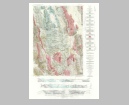
U.S. Geological Survey
Title/Description:
Geologic Map and Sections of Nutmeg Mountain and Vicinity, Washington County, Idaho
Publication Info:
Washington: Department of the Interior, U.S. Geological Survey, 1956; Bulletin 1027-D Plate 5
Viewing Options
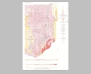
Main Author:
U.S. Geological Survey
Title/Description:
Geologic Map and Sections of the Johnson Creek Quadrangle, Caribou County, Idaho
Publication Info:
Washington: Department of the Interior, U.S. Geological Survey, 1956; Bulletin 1027-A Plate 1
Viewing Options
Main Author:
U.S. Geological Survey
Title/Description:
Geologic and Structure Contour Map and Sections of Goose Creek District, Cassia County, Idaho, and Box Elder County, Utah, and Elco County, Nevada
Publication Info:
Washington: Department of the Interior, U.S. Geological Survey, 1959; Bulletin 1055 Plate 46
Viewing Options
Main Author:
U.S. Geological Survey
Title/Description:
Geologic Map and Sections of the Southern Part of the Lemhi Range, Idaho
Publication Info:
Washington: Department of the Interior, U.S. Geological Survey, 1961; Bulletin 1081-F Plate 7
Viewing Options
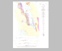
Main Author:
U.S. Geological Survey
Title/Description:
Geologic Map and Section of the Twin Crags Quadrangle, Idaho
Publication Info:
Washington: Department of the Interior, U.S. Geological Survey, 1963; Bulletin 1042-A Plate 1
Viewing Options
Main Author:
U.S. Geological Survey
Title/Description:
Geologic Map and Section of the Clark Fork Quadrangle, Idaho-Montana
Publication Info:
Washington: Department of the Interior, U.S. Geological Survey, 1963; Bulletin 1041-K Plate 1
Viewing Options
Main Author:
U.S. Geological Survey
Title/Description:
Geologic Map and Section of the American Falls Quadrangle, Idaho
Publication Info:
Washington: Department of the Interior, U.S. Geological Survey, 1963; Bulletin 1121-G Plate 1
Viewing Options
Main Author:
U.S. Geological Survey
Title/Description:
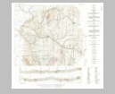
Geologic Map of the Snowdrift Mountain Quadrangle, Bear Lake and Caribou Counties, Idaho
Publication Info:
Washington: Department of the Interior, U.S. Geological Survey, 1964; Bulletin 1153 Plate 1
Viewing Options
Main Author:
U.S. Geological Survey
Title/Description:
Geologic Map of the Georgetown Canyon-Snowdrift Mountain Area, Bear Lake and Caribou Counties, Idaho
Publication Info:
Washington: Department of the Interior, U.S. Geological Survey, 1964; Bulletin 1153 Plate 2
Viewing Options
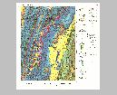
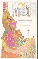
Main Author:
U.S. Geological Survey
Title/Description:
Geologic Map of Idaho
Publication Info:
Washington: Department of the Interior, U.S. Geological Survey; 1978

