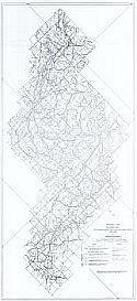
Home  |  Help  |  Graphics Tutorial  |  Aerial Photography  |  Historical Maps  |  Contemporary Maps  |  About this site  | 

Historical Maps of the World

Before 1910
1910-1945
After 1945
Previous Page

  Main Author:   U.S. Geological Survey
  Title/Description:   Geologic Map of the Aliceville, Mantua, and Eutaw Quadrangles, Alabama; showing Pre-Selma Upper Cretaceous Formations
  Publication Info:   Washington, D.C.: Department of the Interior, U.S. Geological Survey, 1946
  Date:   1946
  Scale:   1:63,360
  Original Source:   Geological Survey of Alabama
Viewing options:


  Main Author:   U.S. Geological Survey
  Title/Description:   Geologic Map of the Tertiary Formations of Alabama
  Publication Info:   Washington, D.C.: Department of the Interior, U.S. Geological Survey, 1946; Oil and Gas Investigations, Preliminary Map 45
  Date:   1946
  Scale:   1:500,000
  Original Source:   Geological Survey of Alabama
Viewing options:


  Main Author:   Eangle, D. Hope
  Title/Description:   Correlation of the Pre-Selma Upper Cretaceous Formations between Tuscaloosa County, Alabama and Neshoba County, Mississippi
  Publication Info:   Washington, D.C.: Department of the Interior, U.S. Geological Survey, 1946; Oil and Gas Investigations, Preliminary Chart20
  Date:   1946
  Scale:    
  Original Source:   Geological Survey of Alabama
Viewing options:


  Main Author:   Rothrock, Howard E.
  Title/Description:   Map of the Northeast End of the Coal City Basin, St. Clair County, Alabama Showing Structure and Mined-Out Areas of the Marion and Coal City Coal Beds
  Publication Info:   Washington, D.C.: Bureau of Mines, 1946; Technical Paper 719 Figure 23
  Date:   1946
  Scale:   1:15,840
  Original Source:   Geological Survey of Alabama
Viewing options:


  Main Author:   Eaigle, D. Hoye
  Title/Description:   Profiles showing Geology along highways in the vicinity of Tuscaloosa, Alabama
  Publication Info:   Washington, D.C.: Department of the Interior, U.S.Geological Survey, 1947; with accompanying map
  Date:   1947
  Scale:   1:250,000
  Original Source:   Geological Survey of Alabama
Viewing options:


  Main Author:   U.S. Geological Survey
  Title/Description:   Pre-Selma Upper Cretaceous Stratigraphy in the McCrary, McShan, Gordo, Samantha, and Searles, Quadrangles, Alabama and Mississippi
  Publication Info:   Washington, D.C.: Department of the Interior, U.S. Geological Survey, 1947
  Date:   1947
  Scale:   1:63,360
  Original Source:   Geological Survey of Alabama
Viewing options:


  Main Author:   Rothrock, Howard E.
  Title/Description:   Map of the Coal City and Fairview Basins, Coosa Coal Field, St. Clair County, Alabama Showing Coal Outcrops and Structure
  Publication Info:   Washington, D.C.: Bureau of Mines, 1947; Technical Paper 719 Figure 22
  Date:   1947
  Scale:   1:31,680
  Original Source:   Geological Survey of Alabama
Viewing options:


  Main Author:   U.S. Geological Survey
  Title/Description:   Geology of the Coal City and Fairview Basins, Coosa Coal Field, St. Clair County, Alabama
  Publication Info:   Washington, D.C.: Department of the Interior, U.S. Geological Survey, 1948
  Date:   1948
  Scale:   1:32,000
  Original Source:   Geological Survey of Alabama
Viewing options:


  Main Author:   U.S. Geological Survey
  Title/Description:   Geologic Map and Sections of Hog Mountain
  Publication Info:   Washington, D.C: Department of the Interior, U.S. Geological Survey, 1948; Professional Paper 213, Plate 57
  Date:   1948
  Scale:   1:1,200
  Original Source:   Geological Survey of Alabama
Viewing options:


  Main Author:   Eargle, D. Hoye
  Title/Description:   Correlations of Pre-Selma Upper Creataceous Rocks in Northeastern Mississippi and Northwestern Alabama
  Publication Info:   Washington, D.C.: Department of the Interior, U.S. Geological Survey, 1948; Oil and Gas Investigations, Preliminary Chart 35
  Date:   1948
  Scale:    
  Original Source:   Geological Survey of Alabama
Viewing options:


  Main Author:   Rothrock, Howard E.
  Title/Description:   Maps and Structure Sections of the Coal City and Fairview Basions Coosa Coal Field, St. Clair County, Alabama
  Publication Info:   Washington: Department of the Interior, U.S. Geological Survey
  Date:   1948
  Scale:   1:90,000
  Original Source:   Geological Survey of Alabama
Viewing options:


  Main Author:   Eargle, D. Hoye
  Title/Description:   Geologic Map of the Selma Group in Eastern Alabama
  Publication Info:   Washington, D.C.: Department of the Interior, U.S. Geological Survey, 1950; Oil and Gas Investigations, Preliminary Map 105
  Date:   1950
  Scale:   1:250,000
  Original Source:   Geological Survey of Alabama
Viewing options:


  Main Author:   Carlston, Charles W.
  Title/Description:   Geologic Map of Coastal Alabama
  Publication Info:   Geological Society of America, 1950
  Date:   1950
  Scale:   1:253,440
  Original Source:   Geological Survey of Alabama
Viewing options:


  Main Author:   U.S. Geological Survey
  Title/Description:   Geologic Map Index of Alabama
  Publication Info:   Washington, D.C.: Department of the Interior, U.S. Geological Survey, 1951
  Date:   1951
  Scale:   1:1,000,000
  Original Source:   Geological Survey of Alabama
Viewing options:


  Main Author:   Giffin, Robert H.
  Title/Description:   Geologic Map of a portion of the Hillabee Sill, Talladega Series and Ashland Mica Schist, Alabama
  Publication Info:   Tuscaloosa: Geological Survey of Alabama, 1951; Bulletin 63
  Date:   1951
  Scale:   1:63,360
  Original Source:   Geological Survey of Alabama
Viewing options:


  Main Author:   Drennen, C.W.
  Title/Description:   Geologic Map of Fayette and Lamar Counties, Alabama
  Publication Info:   Washington, D.C.: Department of the Interior, U.S. Geological Survey, 1953; Circular 267 Plate 1
  Date:   1953
  Scale:   1:285,000
  Original Source:   Geological Survey of Alabama
Viewing options:


  Main Author:   Brackeen, L.G.
  Title/Description:   Ground Water, State of Alabama
  Publication Info:   Montgomery: Alabama Department of Agriculture, 1955
  Date:   1955
  Scale:   1:1,440,000
  Original Source:   Geological Survey of Alabama
Viewing options:


  Main Author:   Monreo, Watson H.
  Title/Description:   Preliminary Geologic Map of the Northwestern Part of the Epes Quadrangle, Sumter and Greene Counties, Alabama
  Publication Info:   Washington, D.C.: Department of the Interior, U.S. Geological Survey, 1955; Map OM 167
  Date:   1955
  Scale:   1:31,680
  Original Source:   Geological Survey of Alabama
Viewing options:


  Main Author:   Monreo, Watson H. and James L. Hunt
  Title/Description:   Geologic Map of the Epes Quadrangle, Alabama
  Publication Info:   Washington, D.C.: Department of the Interior, U.S. Geological Survey, 1958
  Date:   1958
  Scale:   1:62,500
  Original Source:   Geological Survey of Alabama
Viewing options:


  Main Author:   U.S. Geological Survey
  Title/Description:   Geologic Map of the Stone Hill Mine, Cleburne and Randolph Counties, Alabama
  Publication Info:   Washington, D.C.: Department of the Interior, U.S. Geological Survey, c.1963; Bulletin 1142-I, Plate 6
  Date:   1963
  Scale:   1:1,200
  Original Source:   Geological Survey of Alabama
Viewing options:


  Main Author:   Warren, W.C.
  Title/Description:   Geologic Map of the Eufaula District, Barbour and Henry Counties, Alabama
  Publication Info:   Washington, D.C.: Department of the Interior, U.S. Geological Survey, 1964; Bulletin 1199-E, Plate 1
  Date:   1964
  Scale:   1:48,000
  Original Source:   Geological Survey of Alabama
Viewing options:


  Main Author:   U.S. Geological Survey
  Title/Description:   Geologic Map Showing Configuration of the base of the Fort Payne Chert, Birmingham Red-Iron-Ore District, Alabama
  Publication Info:   Washington, D.C.: Department of the Interior, U.S. Geological Survey, 1965; Professional Paper 473-C, Plate 1
  Date:   1965
  Scale:   1:24,000
  Original Source:   Geological Survey of Alabama
Viewing options:


  Main Author:   U.S. Geological Survey
  Title/Description:   Geologic map and Sections of the Rock Run and Goshen Valley Areas Cherokee and Calhoun Counties, Alabama
  Publication Info:   Washington, D.C.: Department of the Interior, U.S. Geological Survey, [1966]; Bulletin 1199-N, Plate 1
  Date:   1966
  Scale:   1:48,000
  Original Source:   Geological Survey of Alabama
Viewing options:


  Main Author:   Bergquist, Harlan R.
  Title/Description:   Geologic Map of the Margerum Bauxite District, Colbert County Alabama, showing some structure contours
  Publication Info:   Washington, D.C.: Department of the Interior, U.S. Geologcal Survey, 1966; Bulletin 1199-D, Plate1
  Date:   1966
  Scale:   1:24,000
  Original Source:   Geological Survey of Alabama
Viewing options:


  Main Author:   Daniel, Thomas W., Jr. and Milton H. Fies
  Title/Description:   Strippable Coal in the Fabius Area, Jackson County, Alabama
  Publication Info:   Tuscaloosa: Geological Survey of Alabama, 1968
  Date:   1968
  Scale:   1:11,400
  Original Source:   Geological Survey of Alabama
Viewing options:


  Main Author:   Moore, Donald B.
  Title/Description:   Subsurface Geologic Map of Southwest Alabama
  Publication Info:   Tuscaloosa: Geological Survey of Alabama, 1970
  Date:   1970
  Scale:   1:186,000
  Original Source:   Geological Survey of Alabama
Viewing options:


  Main Author:   McIntosh, Willard L. and Margaret F. Eister
  Title/Description:   Geologic Index of Alabama, 1971
  Publication Info:   Washington, D.C.: U.S. Department of the Interior, U.S. Geological Survey, 1973
  Date:   1973
  Scale:   1:1,000,000
  Original Source:   Geological Survey of Alabama
Viewing options:


  Main Author:   Neathery, Thornton L. and John W. Reynolds
  Title/Description:   Geologic Map of the Lineville East Quadrangle, Alabama
  Publication Info:   Tuscaloosa: Geological Survey of Alabama, 1974; Plate 1
  Date:   1974
  Scale:   1:24,000
  Original Source:   Geological Survey of Alabama
Viewing options:


  Main Author:   Neathery, Thornton L. and John W. Reynolds
  Title/Description:   Geologic Map of the Ofelia Quadrangle, Alabama
  Publication Info:   Tuscaloosa: Geological Survey of Alabama, 1974; Plate 2
  Date:   1974
  Scale:   1:24,000
  Original Source:   Geological Survey of Alabama
Viewing options:


  Main