Use the menu to the right to browse our collection of out-of-print editions of U.S.G.S. Quadrangles. Please keep in mind that map coverage varies and may not be complete for all counties.
Out-of-Print Quadrangles
Main Author
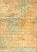
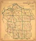
Alabama Highway Dept.
Alabama Highway Dept.
Alabama Highway Dept.
Alabama Highway Dept.
Alabama Highway Dept.
Alabama Highway Dept.
Alabama Highway Dept.
Alabama Highway Dept.
Alabama Highway Dept.
Location
Montgomery County
Montgomery County
Montgomery County
Montgomery County
Montgomery County
Montgomery County
Montgomery County
Montgomery County
Montgomery County
Publication Information
Montgomery: ASHD
Montgomery: ASHD
Montgomery: ASHD
Montgomery: ASHD
Montgomery: ASHD
Montgomery: ASHD
Montgomery: ASHD
Montgomery: ASHD
Montgomery: ASHD
Date
2011
2002
1992
1985
1975
1963
1948
1938
1937
Scale
1:125,000
1:125,000
1:125,000
1:125,000
1:125,000
1:125,000
1:125,000
1:125,000
1:125,000
Viewing Options
Main Author:
LaTourrette, John
Title/Description:
An Accurate Map of the State of Alabama and West Florida [Sheet 12: Autauga, Bibb, Coosa, Montgomery, Shelby, Talladega]
Publication Info:
New York: Colton & Co., 1837
Viewing Options
Main Author:
LaTourrette, John
Title/Description:
An Accurate Map of the State of Alabama and West Florida [Sheet 15: Macon, Montgomery, Pike, Tallapoosa]
Publication Info:
New York: Colton & Co., 1837
Viewing Options
Main Author:
Drawn by Dexter for William Knox
Title/Description:
Plan of the City of Montgomery, from the Corporation Plat
Publication Info:
Unpublished, 1842
Viewing Options
Main Author:
Okelomski, Ferdinand
Title/Description:
Plan of the City of Montgomery
Publication Info:
Baltimore: K. Sachse, 1852
Viewing Options
Main Author:
Barker, H.B.
Title/Description:
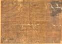
Map of the Estate of the Late John Goldthwaite in Sec. 18, T. 15, R. 18
Publication Info:
Montgomery: H.B. Barker, 1867; copy of 1865 map by H. Haines
Viewing Options
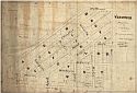
Main Author:
Bibb and Williamson
Title/Description:
Vezuvius. Map of Lots in Sec. 1, T. 16, R. 17 near Montgomery, Alabama
Publication Info:
Bibb and Williamson, 1885
Viewing Options
Title/Description:
City of Montgomery, Alabama
Publication Info:
Montgomery: The State Abstract Company, 1893?
Viewing Options
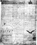
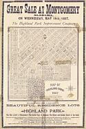
Main Author:
Gaboury, Joseph A.
Title/Description:
[Map of Highland Park, Montgomery, Alabama]
Publication Info:
Montgomery: W.D. Brown & Co., 1887
Viewing Options
Title/Description:
City of Montgomery, Alabama 1899
Publication Info:
The State Abstract Co., 1899
Viewing Options
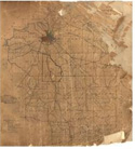
Title/Description:
[Northern Montgomery County]
Publication Info:
Beasley, c.1900; blueprint of original map
Main Author:
Unknown Author
Title/Description:
Montgomery City Plat Maps, 1900
Publication Info:
Unpublished hand drawn maps c.1900
Original Source:
Montgomery County Archives
Main Author:
Unknown Author
Title/Description:
Montgomery County Property Ownership Maps, 1901
Publication Info:
Unpublished hand drawn maps c.1901
Original Source:
Montgomery County Archives
Viewing Options
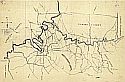
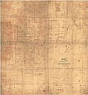
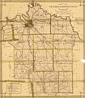
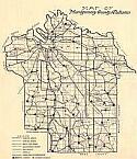
Main Author:
Garrett, J.M.
Title/Description:
Map of Montgomery County, Alabama
Publication Info:
Chicago: Rand McNally & Co., 1901; Made for the Board of Revenue
Viewing Options
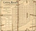
Main Author:
Garrett, J.M.
Title/Description:
Capitol Heights in Eastern Part of City of Montgomery, Alabama
Publication Info:
Buffalo: The Matthews-Northrup Works, 1904
Viewing Options
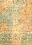
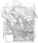
Main Author:
U.S. Department of Agriculture
Title/Description:
Montgomery County soil survey map
Publication Info:
Washington: U.S. Department of Agriculture
Viewing Options
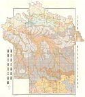
Main Author:
U.S. Department of Agriculture
Title/Description:
Montgomery County soil survey map
Publication Info:
Washington: U.S. Department of Agriculture
Viewing Options
Main Author:
Bullen, J.T.
Title/Description:
Road Map of Montgomery, Alabama
Publication Info:
New York: E.G. Soltmann, 1909
Viewing Options
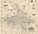
Main Author:
Montgomery City Engineer
Title/Description:
Map of City of Montgomery, Alabama
Publication Info:
New York: E.G. Soltmann, 1909; for the Commercial Club
Viewing Options
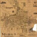
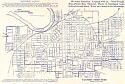
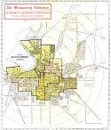
Title/Description:
Map of Montgomery Alabama (produced for the Montgomery Advertiser)
Publication Info:
Des Moines: The Kenyon Co., c1910
Viewing Options
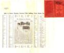
Title/Description:
Index to 1910a
Publication Info:
Des Moines: The Kenyon Co., c1910
Viewing Options
Title/Description:
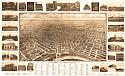
[Montgomery, Alabama]
Publication Info:
Akron, Ohio: S and O Engraving Co., 1912
Viewing Options
Title/Description:
Map of Montgomery County, Alabama [showing roads and schools]
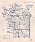
Viewing Options
Main Author:
Farron, Maynard
Title/Description:
Map of Montgomery County, Alabama showing highways and schools
Publication Info:
Montgomery: Thomas H. Edwards, 1920; blueprint reproduction
Original Source:
Montgomery County Archives