Use the menu to the right to browse our collection of out-of-print editions of U.S.G.S. Quadrangles. Please keep in mind that map coverage varies and may not be complete for all counties.
Out-of-Print Quadrangles
Main Author
Alabama Highway Dept.
Alabama Highway Dept.
Alabama Highway Dept.
Alabama Highway Dept.
Alabama Highway Dept.
Alabama Highway Dept.
Alabama Highway Dept.
Alabama Highway Dept.
Alabama Highway Dept.
Alabama Highway Dept.
Alabama Highway Dept.
Alabama Highway Dept.
Alabama Highway Dept.
Alabama Highway Dept.
Location
Mobile County
Mobile County
Mobile County
Mobile County (N)
Mobile County (S)
Mobile County (N)
Mobile County (S)
Mobile County (N)
Mobile County (S)
Mobile County (N)
Mobile County (S)
Mobile County
Mobile County (N)
Mobile County (S)
Publication Information
Montgomery: ASHD
Montgomery: ASHD
Montgomery: ASHD
Montgomery: ASHD
Montgomery: ASHD
Montgomery: ASHD
Montgomery: ASHD
Montgomery: ASHD
Montgomery: ASHD
Montgomery: ASHD
Montgomery: ASHD
Montgomery: ASHD
Montgomery: ASHD
Montgomery: ASHD
Date
2011
2001
1993
1982
1982
1966
1966
1962
1962
1952
1952
1938
1937
1937
Scale
1:125,000
1:125,000
1:125,000
1:125,000
1:125,000
1:125,000
1:125,000
1:125,000
1:125,000
1:125,000
1:125,000
1:125,000
1:125,000
1:125,000
Viewing Options
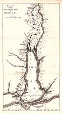
Main Author:
Jefferys, Thomas
Title/Description:
Plan of the Bay and Island of Mobile
Publication Info:
London: 1763
Viewing Options
Main Author:
Trudeau, Carlos
Title/Description:
Plano que feha hallado en la tomada de la Mobile
Publication Info:
Hand drawn, unpublished
Viewing Options
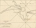
Main Author:
Jefferys, Thomas
Title/Description:
A Draught of the Entrance of Mobile
Publication Info:
London: Sayer and Bennett, 1794
Original Source:
Courtesy of Tom McMillan; Brewton, Alabama
Viewing Options
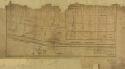
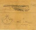
Main Author:
Burgoyne, John Fox
Title/Description:
Sketches of the Operation before Fort Boyer
Publication Info:
Unknown publisher
Viewing Options
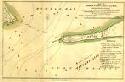
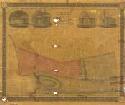
Main Author:
Latour, Major A.L.
Title/Description:
Map of Mobile Point, part of the bay and Dauphine Island showing the position of British land and naval forces
Publication Info:
Unknown publisher
Viewing Options
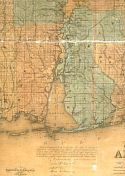
Main Author:
LaTourrette, John
Title/Description:
An Accurate Map of the State of Alabama and West Florida [Sheet 23: Baldwin, Mobile]
Publication Info:
New York: Colton & Co., 1837
Viewing Options
Main Author:
LaTourrette, John
Title/Description:
Map of the City of Mobile
Publication Info:
New York: T. Story & J. Atwood, 1838
Viewing Options
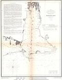
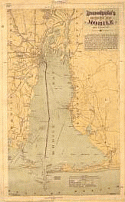
Main Author:
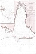
U.S. Coast Survey
Title/Description:
Preliminary Sketch of Mobile Bay
Publication Info:
Washington: 1852
Viewing Options
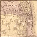
Main Author:
Robertson, William R.
Title/Description:
City of Mobile
Publication Info:
Mobile: William R. Robertson, 1853
Viewing Options
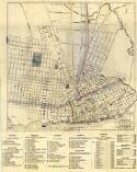
Main Author:
Robertson, William R.
Title/Description:
Robertson's Reference and Distance Plan of Mobile as it is in 1856
Publication Info:
Mobile: William R. Robertson, 1856
Viewing Options
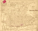
Main Author:
Mitchell, Samuel Augustus
Title/Description:
Mobile
Publication Info:
[Philadelphia: S.A. Mitchell], 1867; inset map found on Mitchell's County Map of Florida
Viewing Options
Title/Description:
Baie de Mobile
Publication Info:
Paris: 1867
Date:
A French reproduction of the US Coastal Survey's 1856 map.
Original Source:
Courtesy of Tom McMillan; Brewton, Alabama
Viewing Options
Main Author:
Mitchell, Samuel Augustus
Title/Description:
Mobile
Publication Info:
[Philadelphia: S.A. Mitchell], 1877; inset map found County Map of Florida
Viewing Options
Title/Description:
Fort Charlotte (about 1820)
Viewing Options
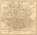
Main Author:
Metzenger, George
Title/Description:
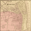
Mobile, 1888
Publication Info:
Boston: Heliotype Printing Co., 1888
Viewing Options
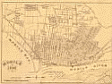
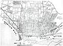
Main Author:
Boudousquie, Paul C.
Title/Description:
Reference Map of Mobile and Vicinity
Publication Info:
New Orleans: T. Fitzwilliams and Co., 1889
Viewing Options
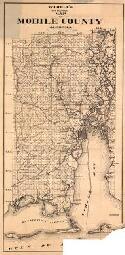
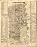
Main Author:
Fonde, Henry
Title/Description:
Township and Sectional map of Mobile County, State of Alabama
Publication Info:
Henry Fonde, 1895
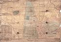
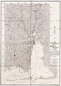
Viewing Options
Main Author:
Pillans, P.J. and Harry Pillans with additions by D.M.N. Ross
Title/Description:
Map of the City of Mobile
Publication Info:
Union Map and Atlas Co., 1901
Viewing Options
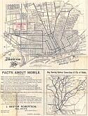
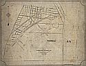
Title/Description:
Map of Mobile
Publication Info:
Published for J.B. Robertson, 1903
Viewing Options
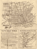
Main Author:
Robertson, J. Bestor
Title/Description:
Map of Mobile, 1903
Publication Info:
St. Louis: Woodward and Tiernan, 1903
Viewing Options
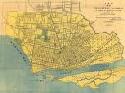
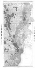
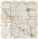
Main Author:
U.S. Department of Agriculture
Title/Description:
Mobile County soil survey map
Publication Info:
Washington: U.S. Department of Agriculture
Viewing Options
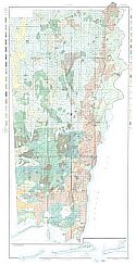
Main Author:
Widell, Theodore
Title/Description:
Widell's New Sectional Map of Mobile County, Alabama
Publication Info:
Mobile: Mobile Stationary Company, [1907]
Viewing Options
Main Author:
Robertson, J. Bestor
Title/Description:
Map of Mobile
Publication Info:
St. Louis: Woodward and Tiernan, 1908
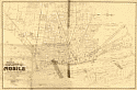
Viewing Options
Title/Description:
City Map of Mobile
Publication Info:
Mobile: Commercial Printing Co., c.1910
Viewing Options
Main Author:
Alabama Land and Development Company
Title/Description:
Map Showing Lands Known as Mobile and Ohio Railroad Lands, in Mobile County, Ala., and Greene County, Miss., Controlled and for sale by Alabama Lands and Development Co.
Publication Info:
Chicago: Poole Brothers, 1911
Viewing Options
Main Author:
U.S. Department of Agriculture
Title/Description:
Mobile County soil survey map
Publication Info:
Washington: U.S. Department of Agriculture, 1911
Viewing Options
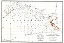
Main Author:
Blanchard, F.W.S.
Title/Description:
Oyster Bottoms of Mississippi Sound, Alabama
Publication Info:
Washington, D.C.: United States Bureau of Fisheries, 1911
Viewing Options
Main Author:
Peavy, John R., Jr.
Title/Description:
Map of Garrows Bend on Mobile Bay Showing Location of Ship Channel Opposite Property of Thos. W. Sims
Publication Info:
Peavy, John R., Jr., 1912

Viewing Options
Main Author:
Peavy, John R.
Title/Description:
Peavy's Reference Map Showing Original Subdivisions, Mobile, Alabama
Publication Info:
Blueprint copy of 1913 map
Viewing Options
Title/Description:
Mobile County, Alabama and Business Directory
Publication Info:
Mobile: Commercial Printing Company, 1915