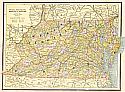
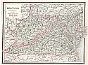
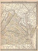
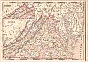
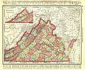
Historical Maps of Other Southeastern States

Selected 
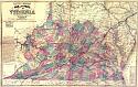
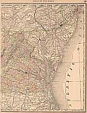
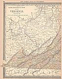
Virginia Out-of-Print Quadrangles USGS or Army Map Service

Next Page

  Main Author:   Bry, Theordorde (info)
  Title/Description:   America pars, Nunc Virginia dicta
  Publication Info:   [Francfort: ad Moemum: T. de Bry, 1590]
  Date:   1585
  Scale:   1:1,500,000
  Original Source:   Rucker Agee Map Collection
Viewing options:


  Main Author:   Robert de Vaugondy, Giles (info)
  Title/Description:   Carte de la Virginie et du Maryland
  Publication Info:   [Paris: Chez de Vaugondy, 1757-58]. From his Universal Atlas, 1757-58
  Date:   1755
  Scale:   1:950,000
  Original Source:   Rucker Agee Map Collection
Viewing options:


  Main Author:    
  Title/Description:   A New and Accurate Map of the Province of Virginia in North America
  Publication Info:   [London: J. Hinton, 1779]. From The Universal Magazine, Vol 65, Dec. 1779. p. 281
  Date:   1779
  Scale:   no scale indicated
  Original Source:   Rucker Agee Map Collection
Viewing options:


  Main Author:   Lodge, John (info)
  Title/Description:   A Map and Chart of those parts of the Bay of Chesapeak, York and James Rivers which are at present The Seat of War
  Publication Info:   London: J. Bew, 1781. From The Political Magazine, Vol. 2, Nov. 1781
  Date:   1781
  Scale:   1:250,000
  Original Source:   Rucker Agee Map Collection
Viewing options:


  Main Author:   Lewis, Samuel  
  Title/Description:   The State of Virginia
  Publication Info:   [Philadelphia: M. Carey, 1794]. From Carey's American Edition of Guthries Geography
  Date:   1794
  Scale:   1:1,585,000
  Original Source:   Rucker Agee Map Collection
Viewing options:


  Main Author:   Morse, J.
  Title/Description:   Virginia
  Publication Info:   Boston: Thomas and Andrews, 1796
  Date:   1796
  Scale:   1:4,435,000
  Original Source:   Courtesy of Murray Hudson, Halls, Tennessee
Viewing options:


  Main Author:   Anderson, John, Jr. and I. Scoles
  Title/Description:   The State of Virginia from the Best Authorities 1799
  Publication Info:   New York: I. Low, 1799; for Paynes New Geography
  Date:   1799
  Scale:   1:3,041,000
  Original Source:   Courtesy of Murray Hudson, Halls, Tennessee
Viewing options:


  Main Author:    
  Title/Description:   Geographical, Statistical, and Historical Map of Virginia
  Publication Info:   Philadelphia: Carey and Lea, 1822. From Carey and Lea's American Atlas of 1822
  Date:   1822
  Scale:   1:1,700,000
  Original Source:   Rucker Agee Map Collection
Viewing options:


  Main Author:   Bradford, Thomas Gamaliel  
  Title/Description:   Virginia, Maryland, and Delaware
  Publication Info:    
  Date:   c. 1835
  Scale:   1:3,165,000
  Original Source:   Rucker Agee Map Collection
Viewing options:


  Main Author:   Bradford, T.G.  
  Title/Description:   Virginia
  Publication Info:   Boston: 1838
  Date:   1838
  Scale:   1:1,900,000
  Original Source:   Alabama Department of Archives and History
Viewing options:


  Main Author:   Mitchell, S. Augustus  
  Title/Description:   A New Map of Virginia with its Canals, Roads, and Distances
  Publication Info:   Philadelphia: S. Augustus Mitchell, 1847
  Date:   1847
  Scale:   1:1,900,000
  Original Source:   Rucker Agee Map Collection
Viewing options:


  Main Author:    
  Title/Description:   A New Map of Virginia with its Canals, Roads, and Distances
  Publication Info:   Philadelphia: Thomas, Cowperthwait & Co., 1850
  Date:   1850
  Scale:   1:1,900,000
  Original Source:   Alabama Department of Archives and History
Viewing options:


  Main Author:   Colton, J.H.  
  Title/Description:   Colton's Virginia
  Publication Info:   NY: J.H. Colton and Co., 1855
  Date:   1855
  Scale:   1:1,900,000
  Original Source:   Rucker Agee Map Collection
Viewing options:


  Main Author:   Lloyd, J.T.
  Title/Description:   Lloyd's Official Map of the State of Virginia
  Publication Info:   New York: Wynkoop and Hallenbeck, 1862
  Date:   1862
  Scale:   1:630,000
  Original Source:   Geological Survey of Alabama
Viewing options:


  Main Author:    
  Title/Description:   Map of the State of Virginia
  Publication Info:   Richmond: West and Johnston, 1862
  Date:   1862
  Scale:   1:825,000
  Original Source:   Rucker Agee Map Collection
Viewing options:


  Main Author:   Johnson and Ward  
  Title/Description:   Johnson's Pennsylvania, Virginia, Delaware, and Maryland
  Publication Info:   [Johnson, c. 1870]
  Date:   1870
  Scale:   1:1,460,000
  Original Source:   Alabama Department of Archives and History
Viewing options:


  Main Author:   Mitchell, S. Augustus  
  Title/Description:   County Map of Virginia and West Virginia
  Publication Info:   Philadelphia: S. Augustus Mitchell, 1876
  Date:   1876
  Scale:   1:1,900,000
  Original Source:   Rucker Agee Map Collection
Viewing options:


  Main Author:   Gray, Frank A.
  Title/Description:   Gray's New Topographical Map of Virginia and West Virginia
  Publication Info:   Philadelphia: O.W. Gray and Son, 1877
  Date:   1877
  Scale:   1:1,000,000
  Original Source:   Courtesy of Murray Hudson, Halls, Tennessee
Viewing options:


  Main Author:   Hardesty, H.H.
  Title/Description:   Map of Virginia and West Virginia
  Publication Info:   New York: H.H. Hardesty & Compay, 1883; from Hardesty's Historical and Geographical Encyclopedia
  Date:   1883
  Scale:   1:1,521,000
  Original Source:   Courtesy of Murray Hudson, Halls, Tennessee
Viewing options:


  Main Author:   Cram, George F.
  Title/Description:   Virginia, West Virginia, Maryland, and Delaware
  Publication Info:   Chicago: George F, Cram, 1885
  Date:   1885
  Scale:   1:2,534,000
  Original Source:   Courtesy of Murray Hudson, Halls, Tennessee
Viewing options:


  Main Author:   Cram, George F.
  Title/Description:   Watson's Atlas Map of Virginia, W. Virginia, Maryland, and Delaware
  Publication Info:   Chicago: Gaylord Watson, 1885; from Watson's New and Complete Illustrated Atlas of the World
  Date:   1885
  Scale:   1:2,534,000
  Original Source:   Courtesy of Murray Hudson, Halls, Tennessee
Viewing options:


  Main Author:   Cram, George F.
  Title/Description:   Virginia, West Virginia, Maryland, and Delaware
  Publication Info:   Chicago: Cram, George F., 1887
  Date:   1887
  Scale:   1:2,534,000
  Original Source:   Courtesy of Murray Hudson, Halls, Tennessee
Viewing options:


  Main Author:   Unknown
  Title/Description:   Map of the Arlington Estates, VA. January 1888 Showing all building occupied by citizens outside of Fort Meyer and the National Cemetery
  Publication Info:   Unknown
  Date:   1888
  Scale:   1:3,200
  Original Source:   Courtesy of Murray Hudson, Halls, Tennessee
Viewing options:


  Main Author:   People's Publishing Co.
  Title/Description:   Virginia, West Virginia, Maryland, & Delaware
  Publication Info:   Rochester: W.H. Stewart & Co., 1888; from The People's Illustrated & Descriptive Family Atlas of the World
  Date:   1888
  Scale:   1:2,534,000
  Original Source:   University of Alabama Map Library
Viewing options:


Main Author:   Rand McNally & Co.
Title/Description:   Virginia and West Virginia
Publication Info:   Chicago: Rand McNally & Co., 1888; from Rand McNally's Standard Atlas of the World
Date:   1888
Scale:   1:2,077,377
Original Source:   University of Alabama Map Library
West
East
Viewing options:
Viewing options:
JPEG or Plugin
JPEG or Plugin


  Main Author:   Cram. George F.
  Title/Description:   Richmond and Manchester, Virginia
  Publication Info:   Chicago: George F. Cram, 1889
  Date:   1889
  Scale:   not indicated
  Original Source:   Courtesy of Murray Hudson, Halls, Tennessee
Viewing options:


  Main Author:   Abert, S.T.
  Title/Description:   Index Map, Pamunky River
  Publication Info:   U.S. Army Corp of Engineers, 1890; to accompany the anual report of 1890
  Date:   1890
  Scale:   1:50,000
  Original Source:   Courtesy of Murray Hudson, Halls, Tennessee
Viewing options:


Main Author:   Rand McNally & Co.
Title/Description:   Map of Virginia
Publication Info:   Chicago: Rand McNally & Co., 1890; from Rand McNally & Co.'s Family Atlas of the World
Date:   1890
Scale:   1:1,521,000
Original Source:   University of Alabama Map Library
West
East
Viewing options:
Viewing options:
JPEG or Plugin
JPEG or Plugin


  Main Author:   Office of the Chief Engineer
  Title/Description:   Norfolk and Western R.R. New River Cripple Creek Mineral Territory
  Publication Info:   Norfolk and Western Rail Road, 1891
  Date:   1891
  Scale:   1:125,000
  Original Source:   Courtesy of Murray Hudson, Halls, Tennessee
Viewing options:


  Main Author:   Rand McNally & Co.
  Title/Description:   Virginia
  Publication Info:   Chicago: Rand McNally & Co., 1893; from Rand McNally & Co.'s Universal Atlas of the World
  Date:   1893
  Scale:   1:1,831,200
  Original Source:   University of Alabama Map Library
Viewing options:
 

  Main Author:   Rand McNally and Company
  Title/Description:   Virginia
  Publication Info:   Chicago: Rand McNally and Company, 1895; From Rand McNally's New General Atlas of the World
  Date:   1895
  Scale:   1:837,440
  Original Source:   Courtesy of Murray Hudson, Halls, Tennessee
Viewing options:


Next Page