Historical Maps of Other Southeastern States

Selected Kansas Out-of-Print Quadrangles
USGS or Army Map Service


Before 1900

Before 1900
1900-1915
After 1915

Next Page

  Main Author:   Calhoun, J.
  Title/Description:   No. 1 Sketch of the Public Surveys in Kansas & Nebraska
  Publication Info:   Washington: Surveyor General's Office, 1855
  Date:   1855
  Scale:   1:1,140,000
  Original Source:   Courtesy of Murray Hudson, Halls, Tennessee
Viewing options:


  Main Author:   Calhoun, J.
  Title/Description:   Plan of the Public Surveys in Kansas and Nebraska
  Publication Info:   Washington: General Land Office, 1856
  Date:   1856
  Scale:   1:1,140,000
  Original Source:   Courtesy of Murray Hudson, Halls, Tennessee
Viewing options:


  Main Author:   Gaston, Samuel N. and Charles W. Morse
  Title/Description:   Kansas and Nebraska
  Publication Info:   New York: Samuel N. Gaston, 1857; from The Diamond Atlas
  Date:   1857
  Scale:   1:3,168,000
  Original Source:   University of Alabama Map Library
Viewing options:


  Main Author:   Colton, Joseph Hutchins
  Title/Description:   Kansas and Nebraska
  Publication Info:   New York: J.H. Colton and Company, 1857
  Date:   1857
  Scale:   1:1,140,000
  Original Source:   Courtesy of Murray Hudson, Halls, Tennessee
Viewing options:


  Main Author:   Delahay, Mark W.
  Title/Description:   (7) Map Showing the Progress of Public Surveys in Kansas and Nebraska
  Publication Info:   Washington: General Land Office, 1861: to accompany the Annual Report of the Surveyor General
  Date:   1861
  Scale:   1:1,140,000
  Original Source:   Courtesy of Murray Hudson, Halls, Tennessee
Viewing options:


  Main Author:   unknown
  Title/Description:   Map of Coffey County Kansas
  Publication Info:   Madison, Wisconsin: c.1870; a supplement from the Lodi Valley News
  Date:   1870
  Scale:   1:1,267,000
  Original Source:   Courtesy of Murray Hudson, Halls, Tennessee
Viewing options:


  Main Author:   Johnson, Alvin J.
  Title/Description:   Johnson's Kansas and Nebraska
  Publication Info:   New York: A.J. Johnson, 1870
  Date:   1870
  Scale:   1:1,394,000
  Original Source:   Courtesy of Murray Hudson, Halls, Tennessee
Viewing options:


  Main Author:   Gray, O.W.
  Title/Description:   Kansas
  Publication Info:   Philadelphia: Stedman, Brown and Lyon, 1873; from The Atlas of the United States, with General Maps of the World, Accompanied by Descriptions Geographical, Historical, Scientific and Statistical
  Date:   1873
  Scale:   1:1,140,000
  Original Source:   Courtesy of Murray Hudson, Halls, Tennessee
Viewing options:


  Main Author:   Mitchell, S. Augustus
  Title/Description:   County and Township Map of the States of Kansas and Nebraska
  Publication Info:   Philadelphia: S. Augustus Mitchell, 1874
  Date:   1874
  Scale:   1:1,900,800
  Original Source:   Antique Atlas
Viewing options:


  Main Author:   Gray, Ormando W.
  Title/Description:   Kansas
  Publication Info:   Philadelphia: O.W. Gray and Son, 1876
  Date:   1876
  Scale:   1:1,140,000
  Original Source:   Courtesy of Murray Hudson, Halls, Tennessee
Viewing options:


  Main Author:   Mitchell, Samuel Augustus, Jr.
  Title/Description:   County and Township Map of the States of Kansas and Nebraska
  Publication Info:   Chicago: S.A. Mitchell, Jr., 1877
  Date:   1877
  Scale:   1:1,901,000
  Original Source:   Courtesy of Murray Hudson, Halls, Tennessee
Viewing options:


  Main Author:   Cram, George F.
  Title/Description:   Cram's Railroad & Township Map of Kansas
  Publication Info:   Chicago: George F. Cram, 1879
  Date:   1879
  Scale:   1:1,204,000
  Original Source:   Courtesy of Murray Hudson, Halls, Tennessee
Viewing options:


  Main Author:   Gray, Frank A.
  Title/Description:   Gray's New Map of Kansas
  Publication Info:   Philadelphia: O.W. Gray & Son, 1881; from The National Atlas
  Date:   1881
  Scale:   1:1,000,000
  Original Source:   Courtesy of Murray Hudson, Halls, Tennessee
Viewing options:


  Main Author:   Bradley, William M.
  Title/Description:   County Map of Kansas
  Publication Info:   Philadelphia: W.M. Bradley, 1881
  Date:   1881
  Scale:   1:3,041,000
  Original Source:   Courtesy of Murray Hudson, Halls, Tennessee
Viewing options:


  Main Author:   Cram, George F.
  Title/Description:   Kansas
  Publication Info:   Chicago: George F. Cram, 1883
  Date:   1883
  Scale:   1:2,218,000
  Original Source:   Courtesy of Murray Hudson, Halls, Tennessee
Viewing options:


  Main Author:   Tunison, H.C.
  Title/Description:   Tunison's Kansas
  Publication Info:   Jacksonville, IL: H.C. Tunison, 1883
  Date:   1883
  Scale:   1:2,091,000
  Original Source:   Courtesy of Murray Hudson, Halls, Tennessee
Viewing options:


  Main Author:   Hardesty, H.H.
  Title/Description:   Map of Kansas
  Publication Info:   New York: H.H. Hardesty and Company, 1883; from The Historical and Geographical Encyclopedia
  Date:   1883
  Scale:   1:1,394,000
  Original Source:   Courtesy of Murray Hudson, Halls, Tennessee
Viewing options:


  Main Author:   O.W. Gray and Son
  Title/Description:   Kansas
  Publication Info:   Philadelphia: O.W. Gray and Son, 1883; from The National Atlas
  Date:   1883
  Scale:   1:1,000,000
  Original Source:   Courtesy of Murray Hudson, Halls, Tennessee
Viewing options:


  Main Author:   Mitchell, Samuel Augustus, Jr.
  Title/Description:   County and Township Map of the States of Kansas and Nebraska
  Publication Info:   Philadelphia: S.A. Mitchell, Jr., 1884
  Date:   1884
  Scale:   1:1,901,000
  Original Source:   Courtesy of Murray Hudson, Halls, Tennessee
Viewing options:


  Main Author:   Cram, George F.
  Title/Description:   Kansas
  Publication Info:   Chicago: Henry S. Stebbing, 1884; from Cram's Unrivaled Family Atlas of the World
  Date:   1884
  Scale:   1:2,217,600
  Original Source:   Courtesy of Murray Hudson, Halls, Tennessee
Viewing options:


  Main Author:   Ramsey, Millett & Hudson
  Title/Description:   
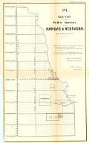
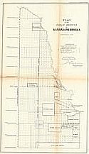
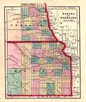
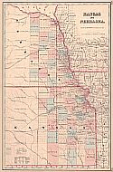
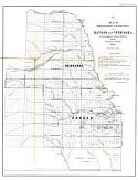
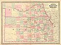
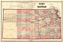
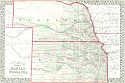
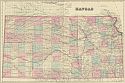
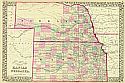
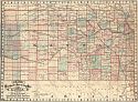
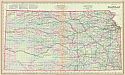
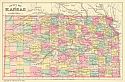
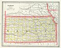
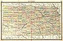
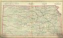
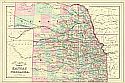
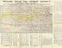
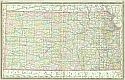
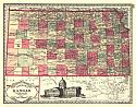
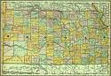
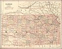
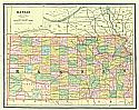
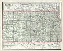
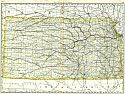
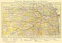
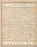
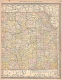
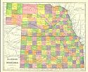
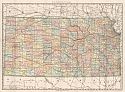
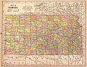
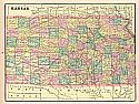
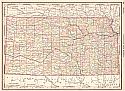
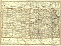
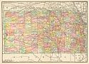
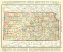
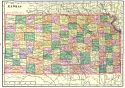
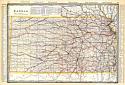
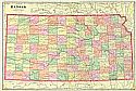
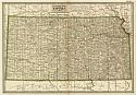
Where Does the Corn Grow? - Golden Belt Lands - Latest Township Map Of Kansas, From Authentic Sources, Drawn And Engraved 1885, Expressly For The Land Department Of The Kansas Division Of The Union Pacific Railway
  Publication Info:   Kansas City: Ramsey, Millett & Hudson, 1885; land promotion brochure issued by B. McAllaster, Land Commissioner, Kansas City, Missouri
  Date:   1885
  Scale:   1:1,394,000
  Original Source:   Courtesy of Murray Hudson, Halls, Tennessee
Viewing options:


  Main Author:   Rand, McNally and Company
  Title/Description:   Kansas
  Publication Info:   Chicago: Rand, McNally and Company, c.1885; from The New Indexed Atlas of the World
  Date:   1885
  Scale:   1:1,394,000
  Original Source:   Courtesy of Murray Hudson, Halls, Tennessee
Viewing options:


  Main Author:   Tunison, Henry Cuthbert
  Title/Description:   Kansas
  Publication Info:   Jacksonville, IL: H.C. Tunison, 1885
  Date:   1885
  Scale:   1:2,091,000
  Original Source:   Courtesy of Murray Hudson, Halls, Tennessee
Viewing options:


  Main Author:   Rand McNally and Company
  Title/Description:   Kansas
  Publication Info:   Chicago: Rand McNally and Company, 1885; from The Standard Atlas of the World
  Date:   1885
  Scale:   1:2,030,207
  Original Source:   Courtesy of Murray Hudson, Halls, Tennessee
Viewing options:


  Main Author:   Cram, George F.
  Title/Description:   Kansas
  Publication Info:   Chicago: Henry S. Stebbing, 1885; from Cram's Unrivaled Family Atlas of the World
  Date:   1885
  Scale:   1:2,217,600
  Original Source:   Courtesy of Murray Hudson, Halls, Tennessee
Viewing options:


  Main Author:   Laskin, Roland (County Clerk)
  Title/Description:   Map of Emporia Kansas
  Publication Info:   Kansas: L.H. Everts and Company, 1886
  Date:   1886
  Scale:   1:18,000
  Original Source:   Courtesy of Murray Hudson, Halls, Tennessee
Viewing options:


  Main Author:   Bradley, William M.
  Title/Description:   Kansas
  Publication Info:   Philadelphia: William M. Bradley and Brother, 1886;
  Date:   1886
  Scale:   1:1,203,840
  Original Source:   Courtesy of Murray Hudson, Halls, Tennessee
Viewing options:


  Main Author:   Mitchell, Samuel Augustus
  Title/Description:   County Map and Township Map of the States of Kansas and Nebraska
  Publication Info:   New York: William M. Bradley and Brothers, 1887; from The New General Atlas of 1887
  Date:   1887
  Scale:   1:1,190,000
  Original Source:   University of Alabama Map Library
Viewing options:


  Main Author:   Cram, George F.
  Title/Description:   Kansas
  Publication Info:   Chicago: George F. Cram, 1887
  Date:   1887
  Scale:   1:2,281,000
  Original Source:   Courtesy of Murray Hudson, Halls, Tennessee
Viewing options:
 

  Main Author:   Cram, George F.
  Title/Description:   Railroad and County Map of Kansas
  Publication Info:   Chicago: George F. Cram, 1887; from The Bankers and Brokers Railroad Atlas
  Date:   1887
  Scale:   1:1,140,480
  Original Source:   Courtesy of Murray Hudson, Halls, Tennessee
Viewing options:


  Main Author:   People's Publishing Company
  Title/Description:   Kansas
  Publication Info:   Chicago: The People's Publishing Company, 1887; from The Peoples Unrivaled Family Atlas of the World
  Date:   1887
  Scale:   1:2,851,200
  Original Source:   Courtesy of Murray Hudson, Halls, Tennessee
Viewing options:


  Main Author:   Peoples Publishing Company
  Title/Description:   Kansas
  Publication Info:   Chicago: People's Publishing Company, 1888
  Date:   1888
  Scale:   1:2,851,000
  Original Source:   Courtesy of Murray Hudson, Halls, Tennessee
Viewing options:


  Main Author:   Cram, George F.
  Title/Description:   Kansas
  Publication Info:   Chicago: George F. Cram, 1888; from The Standard American Atlas
  Date:   1888
  Scale:   1:633,600
  Original Source:   Courtesy of Murray Hudson, Halls, Tennessee
Viewing options:


  Main Author:   Rand McNally and Company
  Title/Description:   Kansas
  Publication Info:   Chicago: Rand McNally and Company, 1889; from The Enlarged Business Atlas and Shippers Guide
  Date:   1889
  Scale:   1:1,013,760
  Original Source:   Courtesy of Murray Hudson, Halls, Tennessee
Viewing options:


  Main Author:   Kansas State Board of Railroad Commissioners
  Title/Description:   Official Railroad Map of Kansas
  Publication Info:   New York: Warner and Beers, c.1890
  Date:   1890
  Scale:   1:1,394,000
  Original Source:   Courtesy of Murray Hudson, Halls, Tennessee
Viewing options:


Main Author:   Rand McNally and Company
Title/Description:   Map of Kansas
Publication Info:   Chicago: Rand McNally and Company, 1890; from The Family Atlas of the World
Date:   1890
Scale:   1:1,394,000
Original Source:   University of Alabama Map Library
West
East
Viewing options:
Viewing options:
JPEG or Plugin
JPEG or Plugin


  Main Author:   Alden, John B.
  Title/Description:   Kansas
  Publication Info:   New York: John B. Alden, 1890; from The Home Atlas of the World
  Date:   1890
  Scale:   1:2,090,880
  Original Source:   Courtesy of Murray Hudson, Halls, Tennessee
Viewing options:


  Main Author:   Cram, George F.
  Title/Description:   Kansas
  Publication Info:   Rochester: W.H. Stewart, c. 1890; from Cram's Unrivaled Atlas of the World
  Date:   1890
  Scale:   1:2,724,480
  Original Source:   Courtesy of Murray Hudson, Halls, Tennessee
Viewing options:


  Main Author:   Fisk and Company
  Title/Description:   Kansas and Nebraska
  Publication Info:   New York: Hunt and Eaton, 1892; from The People's Cyclopaedia
  Date:   1892
  Scale:   1:2,915,000
  Original Source:   Courtesy of Murray Hudson, Halls, Tennessee
Viewing options:


  Main Author:   Rand McNally and Company
  Title/Description:   Rand McNally and Company's Kansas
  Publication Info:   Chicago: Rand McNally and Company, 1892
  Date:   1892
  Scale:   1:1,014,000
  Original Source:   Courtesy of Murray Hudson, Halls, Tennessee
Viewing options:


  Main Author:   Mast, Crowell and Kirkpatrick
  Title/Description:   Map of Kansas
  Publication Info:   New York: Mast, Crowell and Kirkpatrick, 1893; from The Popular Atlas
  Date:   1893
  Scale:   1:2,851,000
  Original Source:   University of Alabama Map Library
Viewing options:


  Main Author:   Cram, George F.
  Title/Description:   Kansas
  Publication Info:   Chicago: John F. Waite, 1893; from the C.A. Gaskell Family and Business Atlas of the World
  Date:   1893
  Scale:   1:2,851,000
  Original Source:   Courtesy of Murray Hudson, Halls, Tennessee
Viewing options:


  Main Author:   Rand McNally and Company
  Title/Description:   Kansas
  Publication Info:   Chicago: Rand McNally and Company, 1893; from The Universal Atlas of the World
  Date:   1893
  Scale:   1:2,091,100
  Original Source:   University of Alabama Map Library
Viewing options:


  Main Author:   Rand McNally and Company
  Title/Description:   Kansas
  Publication Info:  

Chicago: Rand McNally and Company, 1893; from The Enlarged Business Atlas and Shippers Guide

  Date:   1893
  Scale:   1:1,013,760
  Original Source:   Courtesy of Murray Hudson, Halls, Tennessee
Viewing options:


  Main Author:   Cram, George F.
  Title/Description:   Kansas
  Publication Info:   Chicago: John F. Waite; from the International Office and Family Atlas of the World
  Date:   1893
  Scale:   1:2,851,200
  Original Source:   Courtesy of Murray Hudson, Halls, Tennessee
Viewing options:


  Main Author:   Rand McNally and Company
  Title/Description:   Kansas
  Publication Info:   Chicago: The Encyclopedia Britannica Company, c.1895
  Date:   1895
  Scale:   1:2,534,000
  Original Source:   Courtesy of Murray Hudson, Halls, Tennessee
Viewing options:


  Main Author:   Rand McNally and Company
  Title/Description:   Kansas
  Publication Info:   Chicago: Rand McNally and Company 1895; from The New General Atlas of the World
  Date:   1895
  Scale:   1:2,154,240
  Original Source:   Courtesy of Murray Hudson, Halls, Tennessee
Viewing options:


  Main Author:   Walker, H.B.
  Title/Description:   Kansas
  Publication Info:   Chicago: H.B. Walker, 1895; from The International Atlas
  Date:   1895
  Scale:   1:1,203,840
  Original Source:   Courtesy of Murray Hudson, Halls, Tennessee
Viewing options:


  Main Author:   University Geological Survey of Kansas
  Title/Description:   A Reconnaissance Geologic Map of Kansas
  Publication Info:   Topeka: State Printing Office, 1897; Vol II Plate XLVIII
  Date:   1897
  Scale:   not indicated
  Original Source:   University of Alabama Map Library
Viewing options:


  Main Author:   Cram, George F.
  Title/Description:   Kansas
  Publication Info:   Chicago: George F. Cram, 1898; from The Universal Atlas, Geographical, Astronomical and Historical
  Date:   1898
  Scale:   1:2,027,000
  Original Source:   Courtesy of Adams Antiques, Northport, Alabama
Viewing options:


  Main Author:   U.S. Geological Survey
  Title/Description:   Kansas
  Publication Info:   Washington: Department of the Interior, U.S. Geological Survey, 1898; from Bulletin 154 Plate I
  Date:   1898
  Scale:   1:750,000
  Original Source:   Geological Survey of Alabama
Viewing options:


  Main Author:   Cram, George F.
  Title/Description:   Kansas
  Publication Info:   Chicago: George F. Cram, 1899; from Cram's Standard American Railway System Atlas of 1899
  Date:   1899
  Scale:   1:1,267,000
  Original Source:   University of Alabama Map Library
Viewing options:


  Main Author:   Cram, George F.
  Title/Description:   Kansas
  Publication Info:   Chicago: George F. Cram, 1899
  Date:   1899
  Scale:   1:1,267,000
  Original Source:   Courtesy of Murray Hudson, Halls, Tennessee
Viewing options:


  Main Author:   Smith, Benjamin E.
  Title/Description:   Kansas
  Publication Info:   New York: The Century Company, 1899; from The Century Atlas of the World
  Date:   1899
  Scale:   1:1,774,080
  Original Source:   University of Alabama Map Library
Viewing options:
 

Next Page