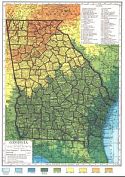
Historical Maps of Other Southeastern States

Georgia Out-of-Print Quadrangles

Before 1825
1826-1850
1851-1875
1876-1900
1901-1925
After 1925

Previous Page

  Main Author:    
  Title/Description:   Hammonds Complete Map of Georgia, Northern Part
  Publication Info:   New York: C.S. Hammond and Co., [1926]
  Date:   1926
  Scale:   1:1,000,000
  Original Source:   University of Alabama Map Library
Viewing options:


  Main Author:    
  Title/Description:   Hammonds Complete Map of Georgia, Southern Part
  Publication Info:   New York: C.S. Hammond and Co., [1926]
  Date:   1926
  Scale:   1:1,000,000
  Original Source:   University of Alabama Map Library
Viewing options:


  Main Author:    
  Title/Description:   Hammond's County Map of Georgia
  Publication Info:   New York: C.S. Hammond and Co., [1929]
  Date:   1929
  Scale:   1:2,218,000
  Original Source:   University of Alabama Map Library
Viewing options:


  Main Author:   Geological Survey of Georgia
  Title/Description:   Geologic Map of Part of the Coastal Plain of Georgia
  Publication Info:   Atlanta: Geological Survey of Georgia, 1929; Bulletin 44
  Date:   1929
  Scale:   1:1,000,000
  Original Source:   University of Alabama Map Library
Viewing options:


  Main Author:   Bureau of the Census
  Title/Description:   Georgia, Minor Civil Divisions (for the Census of 1930)
  Publication Info:   Washington: U.S. Government Printing Office, 1934
  Date:   1930
  Scale:   1:1,000,000
  Original Source:   W. S. Hoole Special Collections Library
Viewing options:


  Main Author:   State Highway Board of Georgia
  Title/Description:   State of Georgia, System of State Roads
  Publication Info:   Atlanta: Foote and Davies Co., [1938]
  Date:   1938
  Scale:   1:950,000
  Original Source:   Rucker Agee Map Collection
Viewing options:


  Main Author:    
  Title/Description:   Walton County, Georgia
  Publication Info:   [Atlanta]: State Highway Board of Georgia, 1939
  Date:   1939
  Scale:   1:63,360
  Original Source:   University of Alabama Map Library
Viewing options:


  Main Author:    
  Title/Description:   Geologic Map of Georgia
  Publication Info:   Georgia Division of Mines, Mining and Geology, 1939
  Date:   1939
  Scale:   1:500,000
  Original Source:   Geological Survey of Alabama
Viewing options:


  Main Author:   Bureau of the Census
  Title/Description:   Georgia Minor Civil Divisions - Militia Districts (1940 census)
  Publication Info:   Washington: U.S. Government Printing Office, 1941
  Date:   1940
  Scale:   1:760,000
  Original Source:   University of Alabama Map Library
Viewing options:


Viewing options:
 
Viewing options:
     
 
Viewing options:
 
Viewing options:
     
 
Viewing options:
 
Viewing options:
     
 
Viewing options:
 
Viewing options:
  Main Author:   Federal Works Agency, Public Roads Administration
  Title/Description:   Georgia Transportation Map
  Publication Info:   [Washington]: 1943
  Date:   1943
  Scale:   1:250,000
  Original Source:   University of Alabama Map Library


  Main Author:   Army Map Service
  Title/Description:   Fort Benning Reservation
  Publication Info:   Washington: Army Map Service, U.S. Army, 1943
  Date:   1943
  Scale:   1:100,000
  Original Source:   Rucker Agee Map Collection
Viewing options:


  Main Author:   Butts, Charles
  Title/Description:   Geologic Map of Northwest Georgia
  Publication Info:   [Atlanta]: Georgia Dept. of Mines, Mining and Geology, 1946
  Date:   1946
  Scale:   1:250,000
  Original Source:   University of Alabama Map Library
Viewing options:


  Main Author:   State Highway Department of Georgia
  Title/Description:   State of Georgia, System of State Roads
  Publication Info:   [Atlanta]: 1946
  Date:   1946
  Scale:   1:950,000
  Original Source:   Rucker Agee Map Collection
Viewing options:


  Main Author:   Bureau of the Census
  Title/Description:   Georgia Minor Civil Divisions - Militia Districts (1950 census)
  Publication Info:   Washington: Government Printing Office, 1952
  Date:   1950
  Scale:   1:760,000
  Original Source:   University of Alabama Map Library
Viewing options:


  Main Author:   Bureau of the Census
  Title/Description:   Georgia Minor Civil Divisions - Militia Districts (1960 census)
  Publication Info:   Washington: Government Printing Office, 1961
  Date:   1960
  Scale:   1:760,000
  Original Source:   University of Alabama Map Library
Viewing options:


  Main Author:   Smith, J. Harmon
  Title/Description:   State of George Showing the Major Campaign Areas and Engagement Sites of The War Between the States, 1861-1865
  Publication Info:   Atlanta: Georgia Department of Commerce, 1961
  Date:   1961
  Scale:   1: 950,400
  Original Source:   Alabama Department of Archives and History
Viewing options:
 

  Main Author:   State Highway Department of Georgia
  Title/Description:   The State of Georgia, Civil War Centennial, 1864, Showing the Major Campaign Areas and Engagement Sites or the Union and Confederates
  Publication Info:   Atlanta: State Highway Department of Georgia, 1964
  Date:   1964
  Scale:   1: 950,400
  Original Source:   Alabama Department of Archives and History
Viewing options:
 

  Main Author:   U.S. Post Office Department
  Title/Description:   State Postal Map, Georgia
  Publication Info:   Washington: U.S. Government Printing Office, 1970
  Date:   1970
  Scale:   1:760,000
  Original Source:   University of Alabama Map Library
Viewing options:


  Main Author:    
  Title/Description:   Geologic Map of Georgia
  Publication Info:   Atlanta: Georgia Geoloigcal Survey, 1976
  Date:   1976
  Scale:   1:500,000
  Original Source:   Geological Survey of Alabama
Viewing options:
 

Previous Page