Home  |  Help  |  Graphics Tutorial  |  Aerial Photography  |  Historical Maps  |  Contemporary Maps  |  About this site  | 

Historical Maps of Other Southeastern States

West Central

.

  Main Author:   Montanus, Arnoldus)
  Title/Description:   Potosi, Bolivia
  Publication Info:   Amersterdam: J. Meuers, 1671
  Date:   1671
  Scale:   oblique view
  Original Source:   Birmingham Public Library Cartographic Collection
Viewing options:


  Main Author:   Mallet, Alain Manesson (info)
  Title/Description:   Cusco
  Publication Info:   Paris: 1683; Figure CLXV from Description de l'Univers
  Date:   1683
  Scale:   oblique view
  Original Source:   Courtesy of Murray Hudson, Halls, Tennessee
Viewing options:


  Main Author:   Mallet, Alain Manesson (info)
  Title/Description:   Montagne de Potosi
  Publication Info:   Paris: 1683; Figure CLXVIII from Description de l'Univers
  Date:   1683
  Scale:   oblique view
  Original Source:   Courtesy of Murray Hudson, Halls, Tennessee
Viewing options:


  Main Author:   Harris, John
  Title/Description:   A Plan of Lima/Potosi
  Publication Info:   London: Emanuel Bown, 1744; from Harris' Nangantium atque Hinerantium Bibliotheca, Volume I, page 243, 1st edition
  Date:   1744
  Scale:   not indicated
  Original Source:   Courtesy of Murray Hudson, Halls, Tennessee
Viewing options:


  Main Author:   Harris, John
  Title/Description:   
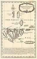
The Gallapagos Islands Discovered and Described by Capt. Cowley in 1684
  Publication Info:   London: Emanuel Bown, 1748; from Harris' Nangantium atque Hinerantium Bibliotheca, Volume I, page 79, 2nd edition
  Date:   1748
  Scale:   1:2,218,000
  Original Source:   Courtesy of Murray Hudson, Halls, Tennessee
Viewing options:


  Main Author:   Bellin, Jacques Nicolas (info)
  Title/Description:   Plan Scenographique de la Cité des Rois ou Lima Capitale du Royaume de Perou
  Publication Info:   Paris: J.N. Bellin, 1757
  Date:   1757
  Scale:   1:12,000
  Original Source:   Courtesy of Murray Hudson, Halls, Tennessee
Viewing options:


  Main Author:   Bellin, Jacques Nicolas (info)
  Title/Description:   Plan de Cusco
  Publication Info:   Paris: J.N. Bellin, 1757; from Histoire Generale des Voyages
  Date:   1757
  Scale:   not indicated
  Original Source:   Courtesy of Murray Hudson, Halls, Tennessee
Viewing options:


  Main Author:   Bellin, Jacques Nicolas (info)
  Title/Description:   Carte du Perou
  Publication Info:   Paris: 1757
  Date:   1757
  Scale:   1:11,000,000
  Original Source:   Courtesy of Antique Atlas
Viewing options:


  Main Author:   Kitchin, Thomas (info)
  Title/Description:   Map of the Countries on the South Sea, From Panama to Guayquil
  Publication Info:   London: W. Strahan and T. Cadell, 1777; for the Rev. Dr. Robertson's History of America
  Date:   1777
  Scale:   1:5,386,000
  Original Source:   Courtesy of Murray Hudson, Halls, Tennessee
Viewing options:


  Main Author:   Bonne, Rigobent (info)
  Title/Description:   Carte du Perou avec une partie des pays qui sont a l'est
  Publication Info:   Geneva: 1780
  Date:   1780
  Scale:   1:10,008,000
  Original Source:   Courtesy of Antique Atlas
Viewing options:


  Main Author:   Carey, Mathew
  Title/Description:   Peru
  Publication Info:   Philadelphia: Mathew Carey, 1814
  Date:   1814
  Scale:   1:8,870,400
  Original Source:   Courtesy of Murray Hudson, Halls, Tennessee
Viewing options:


  Main Author:   Arrowsmith and Lewis
  Title/Description:   Vicroyality of Peru
  Publication Info:   Boston: Thomas and Andrews, 1819; from A New and Elegant General Atlas
  Date:   1819
  Scale:   1:11,088,000
  Original Source:   Courtesy of Murray Hudson, Halls, Tennessee
Viewing options:


  Main Author:   Hall, Sidney
  Title/Description:   Peru
  Publication Info:   London: Longman, Rees, Orme, Brown and Green, 1830
  Date:   1830
  Scale:   1:5,385,600
  Original Source:   Courtesy of Murray Hudson, Halls, Tennessee
Viewing options:


  Main Author:   Monin, C.U. and A.R. Fremin
  Title/Description:   Peru et Bolivia
  Publication Info:   Paris: Armand Aubree, 1836; from Atlas Universel Des Cinq Parties du Monde
  Date:   1836
  Scale:   1:34,645,232
  Original Source:   Courtesy of Murray Hudson, Halls, Tennessee
Viewing options:


  Main Author:   Malte-Brun, Conrad
  Title/Description:   Perou et Bolivia
  Publication Info:   Paris: Aime Andre, 1837
  Date:   1837
  Scale:   1:14,204,900
  Original Source:   Courtesy of Antique Atlas
Viewing options:


  Main Author:   Greenleaf, Jeremiah
  Title/Description:   Peru and Bolivia
  Publication Info:   Brattleboro, VT: Jeremiah Greenleaf, 1840; from A New Universal Atlas
  Date:   1840
  Scale:   1:8,000,000
  Original Source:   Courtesy of Murray Hudson, Halls, Tennessee
Viewing options:


  Main Author:   Morse, Sidney E.
  Title/Description:   South America, West Part
  Publication Info:   New York: Harper and Brothers, 1844; from System of Geography for the Use of Schools
  Date:   1844
  Scale:   1:22,176,000
  Original Source:   Courtesy of Murray Hudson, Halls, Tennessee
Viewing options:


  Main Author:   Tanner, Henry Schenck
  Title/Description:   Peru and Bolivia
  Publication Info:   Philadelphia: S. Augustus Mitchell, 1846; from The New Universal Atlas
  Date:   1846
  Scale:   1:8,236,800
  Original Source:   Courtesy of Murray Hudson, Halls, Tennessee
Viewing options:


  Main Author:   Morse, Sidney E.
  Title/Description:   South America - Western Part
  Publication Info:   New York: Harper and Brothers, 1851; from Morse's School Geography
  Date:   1851
  Scale:   1:22,800,000
  Original Source:   University of Alabama Map Library
Viewing options:


  Main Author:   Society for the Diffusion of Useful Knowledge
  Title/Description:   Bolivia and Peru with part of Brazil
  Publication Info:   London: Charles Knight, 1852; from the General Atlas
  Date:   1852
  Scale:   1:6,779,520
  Original Source:   Courtesy of Murray Hudson, Halls, Tennessee
Viewing options:


  Main Author:   Gibbon, Lardner
  Title/Description:   [Bolivia]
  Publication Info:   Baltimore: A. Hoen and Company, 1854; map drawn by Lieut. Lardner Gibbon, U.S. Navy, to accompany his report
  Date:   1854
  Scale:   1:3,802,000
  Original Source:   Courtesy of Murray Hudson, Halls, Tennessee
Viewing options:


  Main Author:   Mitchell, S.A.
  Title/Description:   Peru and Bolivia
  Publication Info:   Philadelphia: Thomas, Cowperthwait and Company,1854; From The Universal Atlas
  Date:   1854
  Scale:   1:7,920,000
  Original Source:   Courtesy of Murray Hudson, Halls, Tennessee
Viewing options:


  Main Author:   Colton, G.W. and C.B.
  Title/Description:   Colton's Peru and Bolivia
  Publication Info:   New York: G.W. and C.B. Colton, 1855
  Date:   1855
  Scale:   1:7,920,000
  Original Source:   Birmingham Public Library Cartography Collection
Viewing options:


  Main Author:   Malte-Brun, Victor
  Title/Description:   Perou Bolivia et Chili
  Publication Info:   Paris: Gustave Barba, 1856; from Geographie Universelle
  Date:   1856
  Scale:   1:14,572,800
  Original Source:   University of Alabama Map Library
Viewing options:


  Main Author:   Desilver, Charles
  Title/Description:   Peru and Bolivia
  Publication Info:   Philadelphia: Charles Desilver, [1857]; from A New Universal Atlas
  Date:   1857
  Scale:   1:11,400,000
  Original Source:   Courtesy of Adams Antiques, Northport, Alabama
Viewing options:


  Main Author:   Colton, G. Woolworth
  Title/Description:   Peru and Bolivia
  Publication Info:   New York: J.H. Colton and Company, 1857; from The General Atlas
  Date:   1857
  Scale:   1:8,236,800
  Original Source:   Courtesy of Murray Hudson, Halls, Tennessee
Viewing options:


  Main Author:    
  Title/Description:   Peru and Bolivia
  Publication Info:   London: Blackie and Son, 1860; from The Imperial Atlas of Modern Geography
  Date:   1860
  Scale:   1:6,336,000
  Original Source:   Courtesy of Murray Hudson, Halls, Tennessee
Viewing options:


  Main Author:   S. Augustus Mitchell
  Title/Description:   Peru and Bolivia
  Publication Info:   Philadelphia: E.H. Butler and Company, 1870; from Mitchell's New School Atlas
  Date:   1870
  Scale:   1:11,000,000
  Original Source:   University of Alabama Map Library
Viewing options:


  Main Author:    
  Title/Description:   A Plan of Cuzco, Ancient and Modern
  Publication Info:   London: John Murray, 1871; from The Journal of the Royal Geographical Society, Volume 41
  Date:   1871
  Scale:   1:9,000
  Original Source:   Geological Survey of Alabama
Viewing options:


  Main Author:   Mitchell, S. Augustus
  Title/Description:   Map of Chili; Map of Brazil, Bolivia, Paraguay, and Uruguay
  Publication Info:   Philadelphia: S.A. Mitchell, 1873; from Mitchell's New General Atlas
  Date:   1873
  Scale:   various
  Original Source:   University of Alabama Map Library
Viewing options:


  Main Author:   Blackie, Walter Graham
  Title/Description:   Peru and Bolivia
  Publication Info:   London: Blackie and Son, 1886; from The Comprehensive Atlas & Geography of the World
  Date:   1886
  Scale:   1:6,652,800
  Original Source:   University of Alabama Map Library
Viewing options:


  Main Author:   Cram, George F.
  Title/Description:   Peru and Bolivia
  Publication Info:   Chicago: George F. Cram, 1889
  Date:   1889
  Scale:   1:5,700,000
  Original Source:   Courtesy of Murray Hudson, Halls, Tennessee
Viewing options:


  Main Author:   Rand McNally and Company
  Title/Description:   Map of Bolivia, Ecuador and Peru
  Publication Info:   Chicago: Rand McNally and Company, 1892; from The Indexed Atlas of the World
  Date:   1892
  Scale:   1:9,504,000
  Original Source:   Courtesy of Murray Hudson, Halls, Tennessee
Viewing options:


  Main Author:   Bradley, William M.
  Title/Description:   Map of Bolivia
  Publication Info:   New York: John E. Potter and Company,1894; from Potter Bradley Atlas of the World
  Date:   1894
  Scale:   1:6,969,600
  Original Source:   University of Alabama Map Library
Viewing options:


  Main Author:   Bradley, William M.
  Title/Description:   Map of Ecuador
  Publication Info:   New York: John E. Potter and Company,1894; from Potter Bradley Atlas of the World
  Date:   1894
  Scale:   1:2,978,000
  Original Source:   University of Alabama Map Library
Viewing options:


  Main Author:   Rand McNally and Company
  Title/Description:   Northwestern Portion of South America
  Publication Info:   Chicago: The Encyclopedia Britannica Company, c.1895
  Date:   1895
  Scale:   1:12,000,000
  Original Source:   Courtesy of Murray Hudson, Halls, Tennessee
Viewing options:


  Main Author:   Johnston, W. and A.K.
  Title/Description:   Peru
  Publication Info:   Edinburgh: W. and A.K. Johnston, [c. 1897]
  Date:   1897
  Scale:   1:8,870,000
  Original Source:   Courtesy of Adams Antiques, Northport, Alabama
Viewing options:


  Main Author:   Johnston, W. and A.K.
  Title/Description:   Bolivia
  Publication Info:   Edinburgh: W. and A.K. Johnston, [c. 1897]
  Date:   1897
  Scale:   1:8,870,000
  Original Source:   Courtesy of Adams Antiques, Northport, Alabama
Viewing options:


  Main Author:   Cram, George F.
  Title/Description:   Bolivia
  Publication Info:   Chicago: George F. Cram, 1898; from The Universal Atlas, Geographical, Astronomical and Historical
  Date:   1898
  Scale:   1:6,019,000
  Original Source:   Courtesy of Adams Antiques, Northport, Alabama
Viewing options:


  Main Author:   Cram, George F.
  Title/Description:   Peru
  Publication Info:   Chicago: George F. Cram, 1898; from The Universal Atlas, Geographical, Astronomical and Historical
  Date:   1898
  Scale:   1:6,019,000
  Original Source:   Courtesy of Adams Antiques, Northport, Alabama
Viewing options:


  Main Author:   Rand McNally and Company
  Title/Description:   Bolivia, Peru and Ecuador
  Publication Info:   Chicago: Rand McNally and Company, 1898; from The Indexed Atlas of the World
  Date:   1898
  Scale:   1:8,870,400
  Original Source:   Courtesy of Murray Hudson, Halls, Tennessee
Viewing options:


  Main Author:  
  Title/Description:   Ecuador y Peru
  Publication Info:   Barcelona: Editorial FTD, 1900; from Atlas Universal 4 Especial de la America Central
  Date:   1900
  Scale:   1:10,000,000
  Original Source:   University of Alabama Map Library
Viewing options:


  Main Author:  
  Title/Description:   Bolivia
  Publication Info:   Barcelona: Editorial FTD, 1900; from Atlas Universal 4 Especial de la America Central
  Date:   1900
  Scale:   1:6,500,000
  Original Source:   University of Alabama Map Library
Viewing options:


  Main Author:   Habenicht, H. and H. Salzmann
  Title/Description:   Süd-Amerika (West Central)
  Publication Info:   Gotha: Justus Perthes, 1905; from Stielers Hand-Atlas
  Date:   1905
  Scale:   1:7,500,000
  Original Source:   Courtesy of Adams Antiques, Northport, Alabama
Viewing options:


  Main Author:   Habenicht, H. and H. Salzmann
  Title/Description:   Süd-Amerika (East Central)
  Publication Info:   Gotha: Justus Perthes, 1905; from Stielers Hand-Atlas
  Date:   1905
  Scale:   1:7,500,000
  Original Source:   Courtesy of Adams Antiques, Northport, Alabama
Viewing options:


  Main Author:   Rand McNally and Company
  Title/Description:   Ecuador, Peru, & Bolivia
  Publication Info:   Chicago: Rand McNally and Company, 1905; from Indexed Atlas of the World
  Date:   1905
  Scale:   1:6,906,240
  Original Source:   University of Alabama Map Library
Viewing options:


  Main Author:   Rand McNally and Company
  Title/Description:   Ecuador, Peru and Bolivia
  Publication Info:   Chicago: Rand McNally and Company, 1906; from The World and its Peoples
  Date:   1906
  Scale:   1:8,870,400
  Original Source:   University of Alabama Map Library
Viewing options:


  Main Author:   Cram, George F.
  Title/Description:   Map of Bolivia
  Publication Info:   Chicago: George F. Cram, 1907; from The Standard American Atlas
  Date:   1907
  Scale:   1:5,702,400
  Original Source:   University of Alabama Map Library
Viewing options:


  Main Author:   Cram, George F.
  Title/Description:   Peru
  Publication Info:   Chicago: George F. Cram, 1907; from The Standard American Atlas
  Date:   1907
  Scale:   1:5,702,400
  Original Source:   University of Alabama Map Library
Viewing options:


  Main Author:   Rand McNally and Company
  Title/Description:   Ecuador, Peru and Bolivia
  Publication Info:   Chicago: Rand McNally and Company, 1914; from Atlas of Foreign Countries
  Date:   1914
  Scale:   1:6,906,240
  Original Source:   University of Alabama Map Library
Viewing options:


  Main Author:   Rand McNally and Company
  Title/Description:   Ecuador, Peru and Bolivia
  Publication Info:   Chicago: Rand McNally and Company, 1916; from The Ideal Atlas of the World
  Date:   1916
  Scale:    
  Original Source:   Courtesy of Murray Hudson, Halls, Tennessee
Viewing options:


  Main Author:   Philip, George
  Title/Description:   South America: I. North-West
  Publication Info:   London: George Philip and Son, 1921; from Philip's New Handy General Atlas and Gazateer
  Date:   1921
  Scale:   1:9,300,000
  Original Source:   Courtesy of Murray Hudson, Halls, Tennessee
Viewing options:


  Main Author:   Rand McNally and Company
  Title/Description:   Peru, Ecuador, and Western Brazil
  Publication Info:   Chicago: Rand McNally and Company, 1925; from Premier Atlas of the World
  Date:   1925
  Scale:   1:7,920,000
  Original Source:   University of Alabama Map Library
Viewing options:


  Main Author:   Rand McNally and Company
  Title/Description:   Bolivia
  Publication Info:   Chicago: Rand McNally and Company, 1925; from Premier Atlas of the World
  Date:   1925
  Scale:   1:6,526,080
  Original Source:   University of Alabama Map Library
Viewing options:


  Main Author:   Rand McNally and Company
  Title/Description:   Popular Map of Peru, Ecuador, and Western Brazil
  Publication Info:   Chicago: Rand McNally and Company, 1936
  Date:   1936
  Scale:   1:7,920,000
  Original Source:   University of Alabama Map Library
Viewing options:


  Main Author:   Rand McNally and Company
  Title/Description:   Popular Map of Bolivia
  Publication Info:   Chicago: Rand McNally and Company, 1936
  Date:   1936
  Scale:   1:6,526,000
  Original Source:   University of Alabama Map Library
Viewing options:


  Main Author:   Geographical Publishing Company
  Title/Description:   Ecuador and Peru
  Publication Info:   Chicago: Geographical Publishing Company, 1942; from The New International Atlas of the World, War Edition
  Date:   1942
  Scale:   1:10,138,000
  Original Source:   University of Alabama Map Library
Viewing options:


  Main Author:   Geographical Publishing Company
  Title/Description:   Bolivia
  Publication Info:   Chicago: Geographical Publishing Company, 1942; from The New International Atlas of the World, War Edition
  Date:   1942
  Scale:   1:10,138,000
  Original Source:   University of Alabama Map Library
Viewing options:


  Main Author:   U.S. Navy
  Title/Description:   Plans on the Coast of Chile
  Publication Info:   Washington: Hydrographic Office, U.S. Navy, 1943; 1st Edition, No. 5706
  Date:   1943
  Scale:   Various
  Original Source:   University of Alabama Map Library
Viewing options:


  Main Author:   U.S. Navy
  Title/Description:   Antofagasta Road, Caleta Abtao
  Publication Info:   Washington: Hydrographic Office, U.S. Navy, 1944; 22nd Edition, No. 1152
  Date:   1944
  Scale:   1:15,000
  Original Source:   University of Alabama Map Library
Viewing options:


.


© University of Alabama
To purchase map reproductions, submit a quote request.
Download MrSID Plugin