Main Author:   LaTourrette, John  
  Title/Description:   Correct Map of the Seat of War [Mexican-American War]
  Publication Info:   New Orleans: Risso Lith., 1846
  Date:   1846
  Scale:   1:1,400,000
  Original Source:   Alabama Department of Archives and History
Viewing options:


  Main Author:   Hardcastle  
  Title/Description:   Battles of Mexico, Line of Operations of the U.S. Army
  Publication Info:   Philadelphia: P.S. Duval, 1847
  Date:   1847
  Scale:   1:5,400
  Original Source:   Alabama Department of Archives and History
Viewing options:


  Main Author:   Hardcastle  
  Title/Description:   Map of General Worth's Operations
  Publication Info:   [Philadelphia: P.S. Duval], 1847
  Date:   1847
  Scale:   1:1,500
  Original Source:   Alabama Department of Archives and History
Viewing options:


  Main Author:   Hardcastle, Edmd. L.F.  
  Title/Description:   Map of the Valley of Mexico
  Publication Info:   [Washington: Government Printing Office, 1847?]; for the U.S. War Department, Corps of Engineers
  Date:   1847
  Scale:   1:350,000
  Original Source:   Birmingham Public Library Cartography Collection
Viewing options:


  Main Author:   Hardcastle, Edmond L.F. (U.S. Topographical Engineers)
  Title/Description:   Battle of El Molino del Ray (Sept. 8, 1847)
  Publication Info:   Philadelphia: P.S. Duval, [c. 1847]
  Date:   1847
  Scale:   1:7,200
  Original Source:   Alabama Department of Archives and History
Viewing options:


  Main Author:   Pemberton, J.C. (U.S. Topographical Engineers)
  Title/Description:   
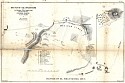
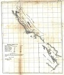
Sketch of the Route of General Worth's Column from Chapultepec to the Alameda (Sept. 13 & 14, 1847)
  Publication Info:   [Unknown publisher]
  Date:   1847
  Scale:   1:22,500
  Original Source:   Courtesy of Adams Antiques, Northport, Alabama
Viewing options:
 

  Main Author:   Hardcastle, Edmond L.F. (U.S. Topographical Engineers)
  Title/Description:   Map of the Valley of Mexico
  Publication Info:   Philadelphia: P.S. Duval, [c. 1847]
  Date:   1847
  Scale:   1:380,000
  Original Source:   Alabama Department of Archives and History
Viewing options:


  Main Author:   U.S. Topographical Engineers
  Title/Description:   Sketch of the Battle of Sacramento (Feb. 18, 1847)
  Publication Info:   [Unknown publisher]
  Date:   1847
  Scale:   not indicated
  Original Source:   Alabama Department of Archives and History
Viewing options:


  Main Author:   U.S. Topographical Engineers
  Title/Description:   [The Coast of California]
  Publication Info:   Philadelphia: P.S. Duval, [c. 1847]
  Date:   1847
  Scale:   1:3,800,000
  Original Source:   Alabama Department of Archives and History
Viewing options:


  Main Author:   Coppee, H. (U.S. Topographical Engineers)
  Title/Description:   Survey of the Mexican Lines of Defence at Cerro Gordo
  Publication Info:   Philadelphia: P.S. Duval, [c. 1847]
  Date:   1847
  Scale:   1:15,840
  Original Source:   Alabama Department of Archives and History
Viewing options:


  Main Author:   Linnard, T.B. (U.S. Topographical Engineers)
  Title/Description:   Plan of the Battle of Buena-Vista Fought February 22 and 23, 1847
  Publication Info:   Philadelphia: P.S. Duval [c. 1847]
  Date:   1847
  Scale:   1:12,000
  Original Source:   Alabama Department of Archives and History
Viewing options:


  Main Author:   U.S. Topographical Engineers
  Title/Description:   Plan Accompanying Gen. Quitman's Report [Chepultepec]
  Publication Info:   Philadelphia: P.S. Duval, [c. 1847]
  Date:   1847
  Scale:   not indicated
  Original Source:   Alabama Department of Archives and History
Viewing options:


  Main Author:   McClellan, John
  Title/Description:   Battle of Cerro Gordo April 17 & 18, 1847
  Publication Info:   1848; drawn from surveys made by Major Turnbull & Captian McClellan
  Date:   1848
  Scale:   1:20,000
  Original Source:   Courtesy of Murray Hudson, Halls, Tennessee
Viewing options:


© University of Alabama
To purchase map reproductions, submit a quote request.
Download MrSID Plugin