| |
| Title
Page |
|
 |
|
| Viewing
options: |
Title |
Scale |
||
| Map of theBighorn Forest Reserve, Wyoming, showing distribution of woodland | 1898 | 1:250,000 | ||
| Teton Forset Reserve and Southern Part of Yellowstone Park Reserve showing land classification | 1898 | 1:250,000 | ||
| Map of Priest River Forest Reserve showing land classification and density of merchantable lumber | 1898 | 1:250,000 | ||
| Map of Priest River Forest Reserve showing distribution of principal timber spaces | 1898 | 1:250,000 | ||
| Map of Washington Forest Reserve showing burned and restocked area and density of merchantable timber in feet B.M. | 1898 | 1:250,000 | ||
| Map of Washington Forest Reserve showing distribution of timber spaces | 1898 | 1:250,000 | ||
| Black Hills Forest Reserve, Harney Peak Quadrangle, South Dakota. Land Classification and density of standing timber | 1898 | 1:250,000 | ||
| Black Hills Forest Reserve, Hermosa Quadrangle, South Dakota. Land Classification and density of standing timber | 1898 | 1:250,000 | ||
| Black Hills Forest Reserve, Rapid Quadrangle, South Dakota. Land Classification and density of standing timber | 1898 | 1:250,000 | ||
| Black Hills Forest Reserve, Deadwood Quadrangle, South Dakota. Land Classification and density of standing timber | 1898 | 1:250,000 | ||
| Black Hills Forest Reserve, Sundance Quadrangle, South Dakota. Land Classification and density of standing timber | 1898 | 1:250,000 | ||
| Preliminary map of western Oregon, showing the density of merchantable timber, expressed in feet, B.M. | 1898 | 1:250,000 | ||
| Battlement Mesa Forest Reserve showing the distribution of commercial timber, burned areas, etc. | 1899 | 1:250,000 | ||
| White River Plateau Timber Reserve showing distribution of commercial timber, burned areas, etc. | 1899 | 1:250,000 | ||
| Pikes Peak, Plum Creek and South Platte Forest Reserves showing burned areas | 1899 | 1:250,000 | ||
| Pikes Peak, Plum Creek and South Platte Forest Reserves showing range of principal timber trees, irrespective of burned areas | 1899 | 1:250,000 | ||
| Pikes Peak, Plum Creek and South Platte Forest Reserves showing density of forests | 1899 | 1:250,000 | ||
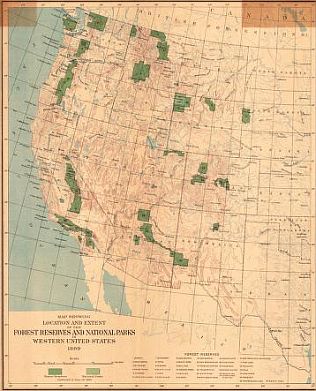
| Map showing location and extent of the forest reserves and national parks in the Western United States | 1899 | 1:6,969,600 | ||
| Bitterroot Forest Reserve showing land classification | 1899 | 1:250,000 | ||
| Seattle Quadrangle, Washington showing classification of lands | 1900 | 1:125,000 | ||
| Mount Stuart Quadrangle, Washington showing classification of lands | 1900 | 1:125,000 | ||
| Ellensburg Quadrangle, Washington showing classification of lands | 1900 | 1:125,000 | ||
| Chelan Quadrangle, Washington showing classification of lands | 1900 | 1:125,000 | ||
| Spokane Quadrangle, Washington showing classification of lands | 1900 | 1:125,000 | ||
| Sandpoint Quadrangle, Washington showing classification of lands | 1900 | 1:125,000 | ||
| Hamilton Quadrangle, Washington showing classification of lands | 1900 | 1:125,000 | ||
| Fortymile Quadrangle, Alaska showing classification of lands | 1900 | 1:250,000 | ||
| Dayton Quadrangle, Wyoming showing classification of lands | 1900 | 1:125,000 | ||
| Bald Mountain Quadrangle, Wyoming showing classification of lands | 1900 | 1:250,000 | ||
| Cloud Peak Quadrangle, Wyoming showing classification of lands | 1900 | 1:250,000 | ||
| Newcastle Quadrangle, Wyoming - South Dakota showing classification of lands | 1900 | |||
| Indian Territory, showing the extent and distribution of woodland | 1900 | 1:500,000 | ||
| Pine Region of Minnesota, showing classifications of lands | 1900 | 1:500,000 | ||
| Forest Reserves and National Parks | 1900 | 1:6,969,600 | ||
| Lewis and Clarke Forest reserveshowing classification of lands | 1900 | 1:506,880 | ||
| Mount Rainier Forest Reserve, showing classification of lands | 1900 | 1:253,440 | ||
| Olympic Forest Reserve, showing classification of lands | 1900 | 1:253,440 | ||
| Olympic Forest Reserve, showing distribution of Red Fir | 1900 | 1:253,400 | ||
| Olympic Forest Reserve, showing distribution of Hemlock | 1900 | 1:253,400 | ||
| Olympic Forest Reserve, showing distribution of Cedar | 1900 | 1:253,400 | ||
| Olympic Forest Reserve, showing distribution of Spruce | 1900 | 1:253,400 | ||
| Olympic Forest Reserve, showing distribution of Silver Fir | 1900 | 1:253,400 | ||
| Ashland Quadrangle, Oregon showing classification of lands | 1900 | 1:250,000 | ||
| Klamath Quadrangle, Oregon showing classification of lands | 1900 | 1:250,000 | ||
| Placerville Quadrangle, California showing classification of lands | 1900 | 1:125,000 | ||
| Pyramid Peak Quadrangle, California showing classification of lands | 1900 | 1:125,000 | ||
| Jackson Quadrangle, California showing classification of lands | 1900 | 1:125,000 | ||
| Big Tree Quadrangle, California showing classification of lands | 1900 | 1:125,000 | ||
| Markleeville Quadrangle, California showing classification of lands | 1900 | 1:125,000 | ||
| Dardanelles Quadrangle, California showing classification of lands | 1900 | 1:125,000 | ||
| Sonora Quadrangle, California showing classification of lands | 1900 | 1:125,000 | ||
| Yosemite Quadrangle, California showing classification of lands | 1900 | 1:125,000 | ||
| Mount Lyell Quadrangle, California showing classification of lands | 1900 | 1:125,000 | ||
| San Jacinto Quadrangle, California showing classification of lands | 1900 | 1:125,000 | ||
| Port Orford Quadrangle, Oregon showing classification of lands | 1900 | 1:125,000 | ||
| Coos Bay Quadrangle, Oregon showing classification of lands | 1900 | 1:125,000 | ||
| Roseburg Quadrangle, Oregon showing classification of lands | 1900 | 1:125,000 | ||
| Tocoma Quadrangle, Washington showing classification of lands | 1900 | 1:125,000 |
|
|
||
|
©
University of Alabama
|
To purchase map reproductions, submit a quote
request.
|
|