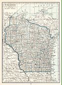
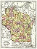
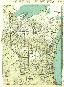
Viewing Options
Main Author:
U.S. Geological Survey
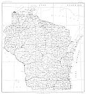
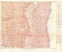
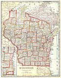
Title/Description:
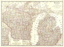
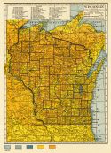
State of Wisconsin
Publication Info:
Washington: Department of the Interior, U.S. Geological Survey, 1918; compiled 1911; reprinted 1944
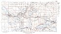
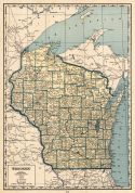
Viewing Options
Main Author:
U.S. Geological Survey
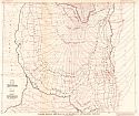
Title/Description:
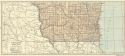
Diagram Showing Direction of Ice Movement in Southeastern Wisconsin
Publication Info:
Washington: Department of the Interior, U.S. Geological Survey, 1918
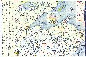
Viewing Options
Main Author:
U.S. Geological Survey
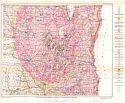
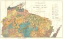
Title/Description:
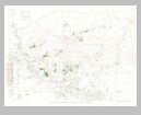
Map Showing the Superficial Deposits of Southeastern Wisconsin
Publication Info:
Washington: Department of the Interior, U.S. Geological Survey, 1918
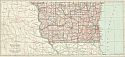
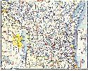
Viewing Options
Main Author:
U.S. Geological Survey
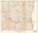
Title/Description:
Map of Southeastern Wisconsin Showing Hypothetical Contours the Configuration of the Surface Bedrock Beneath the Glacial Drift
Publication Info:
Washington: Department of the Interior, U.S. Geological Survey, 1918
Viewing Options
Main Author:
U.S. Geological Survey
Title/Description:
Geologic Map of Southeastern Wisconsin
Publication Info:
Washington: Department of the Interior, U.S. Geological Survey, 1918
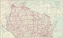
Viewing Options
Main Author:
Whitson, A.R.
Title/Description:
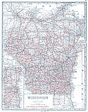
General Map of the Soils of Northern Wisconsin
Publication Info:
Madison: Wisconsin Geological and Natural History Survey, 1918
Viewing Options
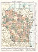
Main Author:
Reynolds, Francis J.
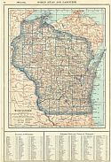
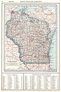
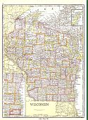
Title/Description:
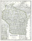
Wisconsin
Publication Info:
New York: P.F. Collier and Son Company, 1920; from The New World Atlas and Gazetteer
Viewing Options
Main Author:
Cram, George F.
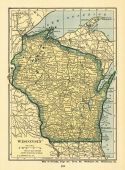
Title/Description:
Wisconsin
Publication Info:
Chicago: George F. Cram, 1920; from Descriptive Review Showing Development of the State of Pennsylvania
Viewing Options
Main Author:
C.S. Hammond and Company
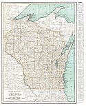
Title/Description:
Wisconsin
Publication Info:
New York: C.S. Hammond and Company, 1920; from The New Reference Atlas of the World
Original Source:
Courtesy of Shawn Carter
Viewing Options
Main Author:
Leslie-Judge Company
Title/Description:
Wisconsin
Publication Info:
New York: Leslie-Judge Company1920; from Leslie's New World Atlas
Viewing Options
Main Author:
Rand McNally and Company
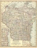
Title/Description:
Wisconsin
Publication Info:
Chicago: Rand McNally and Company, 1921; from The Commercial Atlas of America
Viewing Options
Main Author:
Rand McNally and Company
Title/Description:
Wisconsin - Black and White Mileage Map
Publication Info:
Chicago: Rand McNally and Company, 1921; from The Commercial Atlas of America
Viewing Options
Main Author:
Cram, George F.
Title/Description:
Wisconsin, Michigan
Publication Info:
Chicago: George F. Cram Company, 1921; from Cram's Unrivaled Atlas of the World
Viewing Options
Main Author:
National Map Company
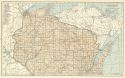
Title/Description:
Wisconsin
Publication Info:
Indianapolis: National Map Company, 1921; from Auto Trails and Commercial Survey of the United States
Viewing Options
Main Author:
National Map Company
Title/Description:
Wisconsin
Publication Info:
Indianapolis: National Map Company, 1921; from Auto Trails and Commercial Survey of the United States
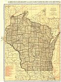
Viewing Options
Main Author:
Wisconsin Geological and Natural History Survey
Title/Description:
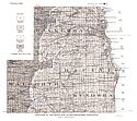
Geological and Road Map of Southeastern Wisconsin
Publication Info:
Madison: The State of Wisconsin, 1921; from Bulletin No. 58, Educational Series No.6
Viewing Options
Main Author:
Wisconsin Geological and Natural History Survey
Title/Description:
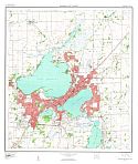
Oconomowoc - Waukesha Lakes
Publication Info:
Madison: The State of Wisconsin, 1921; from Bulletin No. 58, Educational Series No.6
Viewing Options
Main Author:
The Geographical Publishing Co.
Title/Description:
Wisconsin
Publication Info:
Chicago: The Geographical Publishing Co., 1922; from The New International Atlas of the World
Viewing Options
Viewing Options
Main Author:
C.S. Hammond
Title/Description:
Wisconsin
Publication Info:
New York: C.S. Hammond and Company, 1922; from The New World Looseleaf Atlas
Viewing Options
Main Author:
Cram, George F.
Title/Description:
Wisconsin
Publication Info:
Chicago: George F. Cram Company, 1923; from Cram's Unrivaled Atlas of the World
Viewing Options
Main Author:
Reynolds, Francis J.
Title/Description:
Wisconsin
Publication Info:
New York: P.F. Collier and Son Company, 1924; from The New World Atlas and Gazetteer
Viewing Options
Main Author:
Funk and Wagnalls Company
Title/Description:
Wisconsin
Publication Info:
New York: Funk and Wagnalls Company, 1923; from Atlas of the World and Gazetteer
Viewing Options
Main Author:
Rand McNally and Company
Title/Description:
Wisconsin
Publication Info:
Chicago: Rand McNally and Company, 1925; from Premier Atlas of the World
Viewing Options
Main Author:
Clason Map Company
Title/Description:
Best Roads of Wisconsin
Publication Info:
Chicago: Clason Map Company, c. 1927; from Clason's Touring Atlas
Viewing Options
Main Author:
National Map Company
Title/Description:
Wisconsin
Publication Info:
Indianapolis: National Map Company, 1930; from Official Paved Road and Commercial Survey of the United States
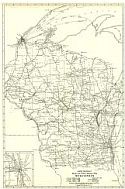
Viewing Options
Main Author:
Clason Map Company
Title/Description:
Clason's Road Map of Wisconsin
Publication Info:
Denver: The Clason Map Company, 1930; from Clason's Touring Atlas of the United States and Canada
Viewing Options
Main Author:
C.S. Hammond and Company
Title/Description:
Wisconsin (Northern Part)
Publication Info:
New York: C.S. Hammond and Company, c. 1930; from The New World Loose Leaf Atlas, Sixth Edition
Viewing Options
Main Author:
C.S. Hammond and Company
Title/Description:
Wisconsin (Southern Part)
Publication Info:
New York: C.S. Hammond and Company, c. 1930; from The New World Loose Leaf Atlas, Sixth Edition
Viewing Options
Main Author:
C.S. Hammond and Company
Title/Description:
Wisconsin
Publication Info:
New York: C.S. Hammond and Company, c. 1930; from The New World Loose Leaf Atlas, Sixth Edition
Viewing Options
Main Author:
Geographical Publishing Company
Title/Description:
Wisconsin
Publication Info:
Chicago: Geographical Publishing Company1931; from Commercial Atlas of the World
Viewing Options
Main Author:
Branom, Frederick K. and Lloyd Edwin Smith
Title/Description:
Wisconsin
Publication Info:
Chicago: Geographical Publishing Company, 1936; from Capper's 1936 Atlas of the World
Viewing Options
Main Author:
Rand McNally and Company
Title/Description:
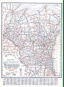
Standard Map of Wisconsin
Publication Info:
Chicago: Rand McNally and Company, 1936
Viewing Options
Main Author:
Geographical Publishing Company
Title/Description:
Wisconsin
Publication Info:
Chicago: Geographical Publishing Company, 1942; from The New International Atlas of the World, War Edition
Viewing Options
Main Author:
Continental Oil Company
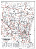
Title/Description:
Highway Map of Wisconsin (North Half)
Publication Info:
Chicago: H.M. Gousha and Company, 1948
Original Source:
Murray Hudson
Viewing Options
Main Author:
Continental Oil Company
Title/Description:
Highway Map of Wisconsin (South Half)
Publication Info:
Chicago: H.M. Gousha and Company, 1948
Original Source:
Murray Hudson
Viewing Options
Main Author:
U.S. Geological Survey
Title/Description:
Geologic Map of the Upper Mississippi Valley Zinc-Lead District, Showing Location of Mined Areas
Publication Info:
Washington: Department of the Interior, U.S. Geological Survey, 1955; Bulletin 1015-G Plate 25
Viewing Options
Main Author:
U.S. Geological Survey
Title/Description:
Madison and Vicinity
Publication Info:
Washington: Department of the Interior, U.S. Geological Survey, 1959

