Viewing Options
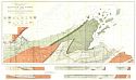
Main Author:
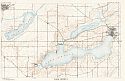
Thwaites, F.T.
Title/Description:
Geological Map of Part of West End of Lake Superior
Publication Info:
Madison: Wisconsin Geological and Natural History Survey, 1911
Viewing Options
Viewing Options
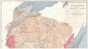
Main Author:
Wisconsin Geological Survey
Title/Description:
Geologic Map of Wisconsin
Publication Info:
Wisconsin Geological Survey, 1911

Viewing Options
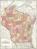
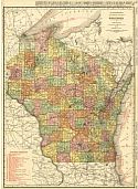
Main Author:
Hammond, C.S.
Title/Description:
Wisconsin
Publication Info:
New York: C.S. Hammond and Company, 1911; from Hammond's Modern Atlas of the World
Viewing Options
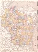
Main Author:
The Geographical Publishing Company
Title/Description:
Wisconsin
Publication Info:
Chicago: Geographical Publishing Company, 1911
Viewing Options
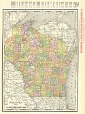
Main Author:
Rand McNally and Company
Title/Description:
Wisconsin
Publication Info:
Chicago: Rand McNally and Co., 1912; from The Library Atlas of the World
Viewing Options
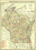
Main Author:
Rand McNally and Company
Title/Description:
Wisconsin
Publication Info:
Chicago: Rand McNally and Company, 1912; from The Rand McNally Imperial Atlas of the World
Viewing Options
Main Author:
Rand McNally and Company
Title/Description:
Rand McNally & Co.'s New Map of Wisconsin
Publication Info:
Chicago: Rand McNally & Co., 1913; from Rand McNally's Bankers' Directory and List of Attorneys

Viewing Options
Main Author:
The Century Company
Title/Description:
Wisconsin
Publication Info:
New York: The Century Company, 1913; from The Century Atlas of the World
Viewing Options
Main Author:
Rand McNally and Company
Title/Description:
Wisconsin
Publication Info:
Chicago: Rand McNally and Co., 1914; from The Commercial Atlas of America
Viewing Options
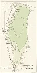
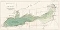
Main Author:
Wisconsin Geological and Natural History Survey
Title/Description:
Hydrographic map of Lake Winnebago
Publication Info:
Madison: Wisconsin Geological and Natural History Survey, 1914; Bulletin No. XXVII, Map XXVI
Viewing Options
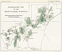
Main Author:
Wisconsin Geological and Natural History Survey
Title/Description:
Hydrographic Map of the Chain O'Lakes, Waupaca
Publication Info:
Madison: Wisconsin Geological and Natural History Survey, 1914; Bulletin No. XXVII, Map XXVII

Viewing Options
Main Author:
Wisconsin Geological and Natural History Survey
Title/Description:
Northeastern Lake District
Publication Info:
Madison: Wisconsin Geological and Natural History Survey, 1914; Bulletin No. XXVII, Map XXVIII
Viewing Options
Main Author:
Wisconsin Geological and Natural History Survey
Title/Description:
Northwestern Lake District
Publication Info:
Madison: Wisconsin Geological and Natural History Survey, 1914; Bulletin No. XXVII, Map XXIX
Viewing Options
Main Author:
Reynolds, Francis J.
Title/Description:
Wisconsin
Publication Info:
New York: P.F. Collier and Son, 1914; from The New Encyclopededic Atlas and Gazatteer of the World
Viewing Options
Main Author:
Wisconsin Geological and Natural History Survey
Title/Description:
Hydrographic Map of Lake Mendota
Publication Info:
Madison: Wisconsin Geological and Natural History Survey, 1914; Bulletin No. XXVII, Map II
Viewing Options
Main Author:
Wisconsin Geological and Natural History Survey
Title/Description:
Hydrographic Map of Lake Monona
Publication Info:
Madison: Wisconsin Geological and Natural History Survey, 1914; Bulletin No. XXVII, Map III
Viewing Options
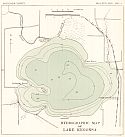
Main Author:
Wisconsin Geological and Natural History Survey
Title/Description:
Hydrographic Map of Lake Kegonsa
Publication Info:
Madison: Wisconsin Geological and Natural History Survey, 1914; Bulletin No. XXVII, Map V
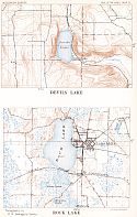
Viewing Options
Main Author:
Wisconsin Geological and Natural History Survey
Title/Description:
Devil's Lake, Rock Lake
Publication Info:
Madison: Wisconsin Geological and Natural History Survey, 1914; Bulletin No. XXVII, Map VI
Viewing Options
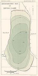
Main Author:
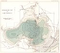
Wisconsin Geological and Natural History Survey
Title/Description:
Hydrographic Map of Devil's Lake
Publication Info:
Madison: Wisconsin Geological and Natural History Survey, 1914; Bulletin No. XXVII, Map VIII
Viewing Options
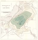
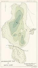
Main Author:
Wisconsin Geological and Natural History Survey
Title/Description:
Hydrographic Map of Rock Lake
Publication Info:
Madison: Wisconsin Geological and Natural History Survey, 1914; Bulletin No. XXVII, Map VII
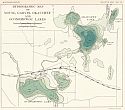
Viewing Options
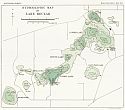
Main Author:
Wisconsin Geological and Natural History Survey
Title/Description:
Oconomowoc - Waukesha Lakes
Publication Info:
Madison: Wisconsin Geological and Natural History Survey, 1914; Bulletin No. XXVII, Map IX
Viewing Options
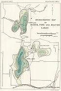
Main Author:
Wisconsin Geological and Natural History Survey
Title/Description:
Hydrographic Map of North Pine and Beaver Lakes
Publication Info:
Madison: Wisconsin Geological and Natural History Survey, 1914; Bulletin No. XXVII, Map X
Viewing Options
Main Author:
Wisconsin Geological and Natural History Survey
Title/Description:
Hydrographic Map of Mouse, Garvin, Okauchee and Oconomowoc Lakes
Publication Info:
Madison: Wisconsin Geological and Natural History Survey, 1914; Bulletin No. XXVII, Map XI

Viewing Options
Main Author:
Wisconsin Geological and Natural History Survey
Title/Description:
Hydrographic Map of Lac La Belle and Fowler Lake
Publication Info:
Madison: Wisconsin Geological and Natural History Survey, 1914; Bulletin No. XXVII, Map XII
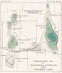
Viewing Options
Main Author:
Wisconsin Geological and Natural History Survey
Title/Description:
Hydrographic map of Nagawicka, Nashotah and Nemahbin Lakes
Publication Info:
Madison: Wisconsin Geological and Natural History Survey, 1914; Bulletin No. XXVII, Map XIII
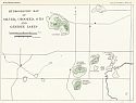
Viewing Options
Main Author:
Wisconsin Geological and Natural History Survey
Title/Description:
Hydrographic Map of Silver, Crooked, Otis, and Genesee Lakes
Publication Info:
Madison: Wisconsin Geological and Natural History Survey, 1914; Bulletin No. XXVII, Map XIV
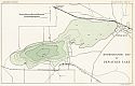
Viewing Options
Main Author:
Wisconsin Geological and Natural History Survey
Title/Description:
Hydrographic Map of Pewaukee Lake
Publication Info:
Madison: Wisconsin Geological and Natural History Survey, 1914; Bulletin No. XXVII, Map XV
Viewing Options
Main Author:
Wisconsin Geologicala and Natural History Survey
Title/Description:
Lake Geneva
Publication Info:
Madison: Wisconsin Geological and Natural History Survey, 1914; Bulletin No. XXVII, Map XVI
Viewing Options
Main Author:
Wisconsin Geological and Natural History Survey
Title/Description:
Hydrographic Map of Lake Geneva
Publication Info:
Madison: Wisconsin Geological and Natural History Survey, 1914; Bulletin No. XXVII, Map XVII

Viewing Options
Main Author:
Wisconsin Geological and Natural History Survey
Title/Description:
Hydrographic Map of Delavan Lake
Publication Info:
Madison: Wisconsin Geological and Natural History Survey, 1914; Bulletin No. XXVII, Map XVIII
Viewing Options
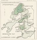
Main Author:
Wisconsin Geological and Natural History Survey
Title/Description:
Hydrographic Map of Lauderdale Lakes
Publication Info:
Madison: Wisconsin Geological and Natural History Survey, 1914; Bulletin No. XXVII, Map XIX

Viewing Options
Main Author:
Wisconsin Geological and Natural History Survey
Title/Description:
Lake Beulah
Publication Info:
Madison: Wisconsin Geological and Natural History Survey, 1914; Bulletin No. XXVII, Map XX
Viewing Options
Main Author:
Wisconsin Geological and Natural History Survey
Title/Description:
Hydrographic map of Lake Beulah
Publication Info:
Madison: Wisconsin Geological and Natural History Survey, 1914; Bulletin No. XXVII, Map XXI
Viewing Options
Main Author:
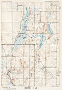
Wisconsin Geological and Natura History Survey
Title/Description:
Cedar Lake
Publication Info:
Madison: Wisconsin Geological and Natural History Survey, 1914; Bulletin No. XXVII, Map XXII
Viewing Options
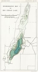
Main Author:
Wisconsin Geological and Natural History Survey
Title/Description:
Hydrographic Map of Big Cedar Lake
Publication Info:
Madison: Wisconsin Geological and Natural History Survey, 1914; Bulletin No. XXVII, Map XXIII
Viewing Options
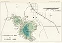
Main Author:
Wisconsin Geological and Natural History Survey
Title/Description:
Hydrographic Map of Elkhart Lake
Publication Info:
Madison: Wisconsin Geological and Natural History Survey, 1914; Bulletin No. XXVII, Map XXIV
Viewing Options
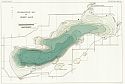
Main Author:
Wisconsin Geological and Natural History Survey
Title/Description:
Hydrogrpahic Map of Geen Lake
Publication Info:
Madison: Wisconsin Geological and Natural History Survey, 1914; Bulletin No. XXVII, Map XXV

Viewing Options
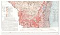
Main Author:
Hotchkiss, W.O.
Title/Description:
Map Showing Geology of Part of Northwestern Wisconsin
Publication Info:
Madison: Wisconsin Geological and Natural History Survey, 1915; Bulletin XLIV Plate I

Viewing Options
Main Author:
Wisconsin Geological and Natural History Survey
Title/Description:
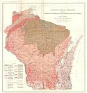
Map Showing Swamp Lands of Wisconsin
Publication Info:
Madison: Wisconsin Geological and Natural History Survey, 1915; Bulletin XLV
Viewing Options
Main Author:
Weidman, Samuel
Title/Description:
Geological Map of Wisconsin Showing Artesian Conditions and Elevations of the Pre-Cambrian
Publication Info:
Madison: Wisconsin Geological and Natural History Survey, 1915; Bulletin XXXV Plate I
Viewing Options
Main Author:
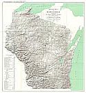
Martin, Lawrence
Title/Description:
Relief Map of Wisconsin
Publication Info:
Madison: Wisconsin Geological and Natural History Survey, 1915; Bulletin XXXVI Plate I
Viewing Options
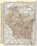
Main Author:
Rand McNally and Company
Title/Description:
Wisconsin
Publication Info:
Chicago: Rand McNally and Company, 1915; from The Ideal Atlas of the World

