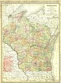
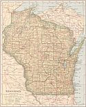
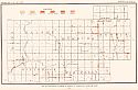
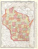
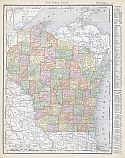
Viewing Options
Main Author:
Rand McNally and Company
Title/Description:
Wisconsin
Publication Info:
Chicago: Rand McNally and Company, 1906; from The Business Atlas and Shippers Guide
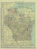
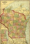
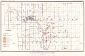
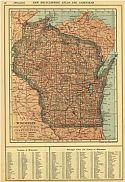
Viewing Options
Main Author:
Hammond, C.S.
Title/Description:
Wisconsin
Publication Info:
New York: C.S. Hammond and Company, 1906; from The Pictorial Atlas of the World
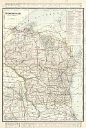
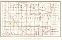
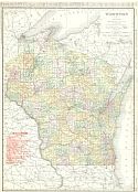
Viewing Options
Main Author:
Cram, George F.
Title/Description:
Wisconsin
Publication Info:
Chicago: George F. Cram for A. A. Grant, Toronto, Ont., 1906; from Grant's Bankers and Brokers Railroad System Atlas
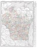
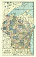
Viewing Options
Main Author:
Rand McNally and Company
Title/Description:
Wisconsin
Publication Info:
Chicago: Rand McNally and Company, 1906; from The World and its Peoples
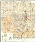
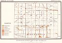
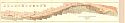
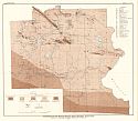
Viewing Options
Main Author:
Weidman, Samuel
Title/Description:
Map of the Cambrian and Pre-Cambrian of North Central Wisconsin
Publication Info:
Madison: Wisconsin Geological and Natural History Survey, 1907; Bulletin XVI Plate I
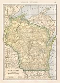
Viewing Options
Main Author:
Cram, George F.
Title/Description:
Map of Wisconsin
Publication Info:
Chicago: George F. Cram, 1907; from Cram's Standard American Atlas
Viewing Options
Main Author:
P.F. Collier and Son
Title/Description:
Wisconsin
Publication Info:
New York: P.F. Collier and Son, 1907; from The New Encyclopedic Atlas and Gazetteer of the World
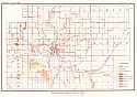
Viewing Options
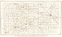
Main Author:
Wisconsin Geological and Natural History Survey
Title/Description:
Map Showing Rock Outcrops in Vicinity of Wausau
Publication Info:
Madison: Wisconsin Geological and Natural History Survey, 1907; Bulletin No. XVI, Plate IV
Viewing Options
Main Author:
Wisconsin Geological and Natural History Survey
Title/Description:
Map Showing Rock Outcrops in Vicinity of Athens and Upper Rib River
Publication Info:
Madison: Wisconsin Geological and Natural History Survey, 1907; Bulletin No. XVI, Plate VIII
Viewing Options
Main Author:
Wisconsin Geological and Natural History Survey
Title/Description:
Map Showing Rock Outcrops in Vicinity of Merrill
Publication Info:
Madison: Wisconsin Geological and Natural History Survey, 1907; Bulletin No. XVI, Plate IX
Viewing Options
Main Author:
Wisconsin Geological and Natural History Survey
Title/Description:
Map showing rock outcrops in vicinity of Arpin and Junction City
Publication Info:
Madison: Wisconsin Geological and Natural History Survey, 1907; Bulletin No. XVI, Plate XII
Viewing Options
Main Author:
Wisconsin Geological and Natural History Survey
Title/Description:
Map Showing rock outcrops in vicinity of Mosinee
Publication Info:
Madison: Wisconsin Geological and Natural History Survey, 1907; Bulletin No. XVI, Plate XIV
Viewing Options
Main Author:
Wisconsin Geological and Natural History Survey
Title/Description:
Map Showing rock outcrops in vicinity of Hewitt and Rozellville
Publication Info:
Madison: Wisconsin Geological and Natural History Survey, 1907; Bulletin No. XVI, Plate XV
Viewing Options
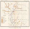
Main Author:
Wisconsin Geological and Natural History Survey
Title/Description:
Map Showing Thickness of Drift of the Marshfield Moraine and Adjacent Area
Publication Info:
Madison: Wisconsin Geological and Natural History Survey, 1907; Bulletin No. XVI, Plate L
Viewing Options
Main Author:
The Crowell Publishing Company
Title/Description:
Wisconsin
Publication Info:
New York: The Crowell Publishing Co., 1908; from The Peerless Atlas of the World
Viewing Options
Main Author:
Hammond, C.S.
Title/Description:
Wisconsin
Publication Info:
New York: C.S. Hammond & Co. 1908; from Hammond's Handy Atlas of the World
Viewing Options
Main Author:
Rand McNally and Company
Title/Description:
Wisconsin
Publication Info:
Chicago: Rand McNally and Company, 1908; from The New Ideal State and County Survey and Atlas
Viewing Options
Main Author:
Patten, William and J.E. Homas
Title/Description:
Wisconsin
Publication Info:
New York: P.F. Collier and Son, 1909; from The New Encyclopedic Atlas and Gazetteer of the World
Viewing Options
Main Author:
U.S. Geological Survey
Title/Description:
Geologic Map of the Penokee-Gogebec District, Wisconsin-Michigan
Publication Info:
Washington: Department of the Interior, U.S. Geological Survey, 1909; Monograph 52 Plate 16
Viewing Options
Main Author:
Rand McNally and Company
Title/Description:
Wisconsin
Publication Info:
Chicago: Rand McNally and Company, 1910; from The Enlarged Business Atlas and Shippers Guide
Viewing Options
Main Author:
U.S. Geological Survey
Title/Description:
Outcrop Map of the Florence Iron District, Wisconsin
Publication Info:
Washington: Department of the Interior, U.S. Geological Survey, 1910; Monograph 52 Plate 25
Viewing Options
Main Author:
Rand McNally and Company
Title/Description:
Wisconsin
Publication Info:
Chicago: Rand McNally and Company 1910; from New Ideal State and County Survey

