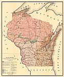
Viewing Options
Main Author:
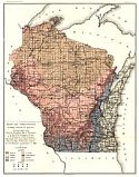
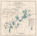
Buckley, E.R.
Title/Description:
Map of Wisconsin Showing Location of Quarries
Publication Info:
Madison: Wisconsin Geological and Natural History Survey, 1898; from Bulletin No. 4, Economic Series No. 2
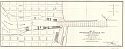
Viewing Options
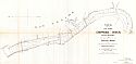
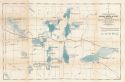
Main Author:
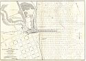
U.S. Army Corps of Engineers
Title/Description:
Map of the Chippewa River, Wisconsin, Two Miles South of Dells Dam
Publication Info:
Washington: U.S. House of Representatives, 54th Congress, 1st Session, Doc. No. 245
Viewing Options
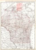
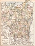
Main Author:
Rand McNally and Company
Title/Description:
Wisconsin
Publication Info:
Chicago: Rand McNally and Company, 1896; from Enlarged Business Atlas
Viewing Options
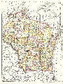
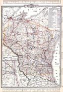
Main Author:
Rand McNally and Company
Title/Description:
Wisconsin
Publication Info:
Chicago: Rand McNally and Company,1896; from Indexed Atlas of the World
Viewing Options
Main Author:
U.S. Army Corps of Engineers
Title/Description:
Map of Sheboygan Harbor, Wis.
Publication Info:
Washington: U.S. House of Representatives, 54th Congress, 2nd Session, Doc. No. 327
Viewing Options
Main Author:
U.S. Army Corps of Engineers
Title/Description:
Map of Survey of Harbor of LaCrosse, Wis.
Publication Info:
Washington: U.S. House of Representatives, 54th Congress, 2nd Session, Doc. No. 210
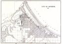
Viewing Options
Main Author:
Cram, George F.
Title/Description:
City of Superior, Wisconsin
Publication Info:
Chicago: George F. Cram, 1898; from Cram's Universal Atlas, Geographical, Astronomical and Historical
Viewing Options
Main Author:
Funk & Wagnalls Company
Title/Description:
Wisconsin
Publication Info:
New York: Funk & Wagnalls Co., 1898; from A Standard Atlas of the World
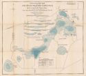
Viewing Options
Main Author:
Trippe, H.M.
Title/Description:
Hydrographic Map of Lake Beulah, Walworth County, Wisconsin
Publication Info:
Madison: Wisconsin Geological and Natural History Society, 1898
Viewing Options
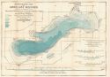
Main Author:
Trippe, H.M.
Title/Description:
Hydrographic Map of Lake Geneva, Wisconsin
Publication Info:
Madison: Wisconsin Geological and Natural History Survey, 1898
Viewing Options
Main Author:
Marsh, C. Dwight
Title/Description:
Hydrographic Map of Green Lake, Green Lake County, Wis.
Publication Info:
Madison: Wisconsin Geological and Natural History Survey, 1898
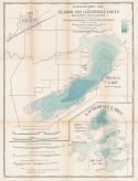
Viewing Options
Title/Description:
Hydrographic Map of Delavan and Lauderdale Lakes, Walworth County, Wis.
Publication Info:
Madison: Wisconsin Geological and Natural History Survey, 1898
Viewing Options
Title/Description:
Hydrographic Map of the Chain-O'-Lakes, Waupaca County, Wis.
Publication Info:
Madison: Wisconsin Geological and Natural History Survey, 1898
Viewing Options
Main Author:
Tripp, H.M. and L.S. Smith
Title/Description:
Hydrographic Map of the Oconomowoc-Waukesha Lake District, Waukesha County, Wis.
Publication Info:
Madison: Wisconsin Geological and Natural History Survey, 1898
Viewing Options
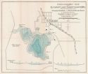
Title/Description:
Hydrographic Map of Elkhart Lake, Sheboygan County, Wis.
Publication Info:
Madison: Wisconsin Geological and Natural History Survey, 1898
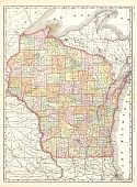
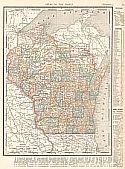
Viewing Options
Main Author:
Rand McNally and Company
Title/Description:
Wisconsin
Publication Info:
Chicago: Rand McNally and Company, c.1898
Viewing Options
Main Author:
Mast, Crowell and Kirkpatrick
Title/Description:
Wisconsin
Publication Info:
Springfield, Ohio: Mast, Crowell and Kirkpatrick, 1898; from The New Peerless Atlas of the World
Viewing Options
Main Author:
Cram, George F.
Title/Description:
Wisconsin (RailRoad Map)
Publication Info:
Chicago: George F. Cram, 1899
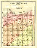
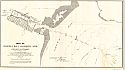
Viewing Options
Title/Description:
Geological Map of Douglas County, Wisconsin
Publication Info:
Madison: Wisconsin Geological and Natural History Survey, 1899; Bulletin VI Plate I
Viewing Options
Main Author:
Smith, Benjamin E.
Title/Description:
Wisconsin
Publication Info:
New York: The Century Company, 1899; from The Century Atlas of the World
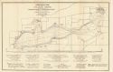
Viewing Options
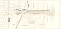
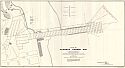
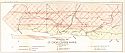
Main Author:
U.S. Army Corps of Engineers
Title/Description:
Map of Kenosha Harbor, Wis.
Publication Info:
Washington: U.S. House of Representatives, 55th Congress, 3rd Session, Doc. No. 164
Viewing Options
Main Author:
U.S. Army Corps of Engineers
Title/Description:
Map of Racine Harbor, Wis.
Publication Info:
Washington: U.S. House of Representatives, 55th Congress, 3rd Session, Doc. No. 165
Viewing Options
Main Author:
U.S. Army Corps of Engineers
Title/Description:
Map of the Harbor of Port Wing, Wisconsin
Publication Info:
Washington: U.S. House of Representatives, 56th Congress, 1st Session, Doc. No. 114
Viewing Options
Main Author:
The Bradstreet Company
Title/Description:
Wisconsin
Publication Info:
New York: The Bradstreet Company, 1899; from Bradstreet's Pocket Atlas of the United States
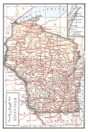
Viewing Options
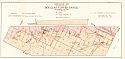
Main Author:
Buckley, E.R.
Title/Description:
Map of Wisconsin Showing the Approximate Distribution of the Clays and Shales and the Location of Brick and Drain Tile Factories, June 1,1900
Publication Info:
Madison: Wisconsin Geological and Natural History Survey, 1900; Bulletin VII Plate I
Viewing Options
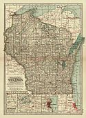
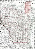
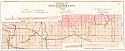
Main Author:
Rand McNally & Company
Title/Description:
Wisconsin Railroads
Publication Info:
Chicago: Rand McNally & Company, 1900
Viewing Options
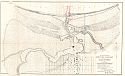
Main Author:
U.S. Army Corps of Engineers
Title/Description:
Map of Manitowoc Harbor, Wis., Showing proposed extension of breakwater
Publication Info:
Washington: U.S. House of Representatives, 56th Congress, 1st Session, Doc. No. 233
Viewing Options
Main Author:
U.S. Army Corps of Engineers
Title/Description:
Map of Green Bay Harbor
Publication Info:
Washington: U.S. House of Representatives, 56th Congress, 1st Session, Doc. No. 232
Viewing Options
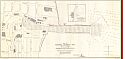
Main Author:
U.S. Army Corps of Engineers
Title/Description:
Map of Kewaunee Harbor, Wis.
Publication Info:
Washington: U.S. House of Representatives, 56th Congress, 1st Session, Doc. No. 362
Viewing Options
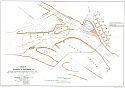
Main Author:
Wisconsin Geological and Natural History Survey
Title/Description:
Geological Map of Part of the St. Croix Copper Range, in Douglas Co., Wis.
Publication Info:
Madison: The Survey, 1900; Bulletin No. VI, Plate VII
Viewing Options
Main Author:
Wisconsin Geological and Natural History Survey
Title/Description:
Geological Map of the Western Part of the Douglas Copper Range, in Douglas Co., Wis.
Publication Info:
Madison: The Survey, 1900; Bulletin No. VI, Plate VIII
Viewing Options
Main Author:
Wisconsin Geological and Natural History Survey
Title/Description:
Geological Map of the Eastern Part of the Douglas Copper Range, in Douglas Co., Wis.
Publication Info:
Madison: The Survey, 1900; Bulletin No. VI, Plate IX
Viewing Options
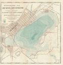
Title/Description:
Hydrographic Map of Lake Monona, Dane County, Wis.
Publication Info:
Madison: Wisconsin Geological and Natural History Survey, 1900

