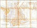
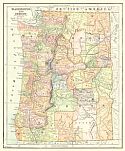
Home  |  Help  |  Graphics Tutorial  |  Aerial Photography  |  Historical Maps  |  Contemporary Maps  |  About this site  | 

Historical Maps of Other Southeastern States

Selected Washington Out-of-Print Quadrangles

Next Page

  Main Author:   Colton, Joseph Hutchins
  Title/Description:   The Territories of Washington and Oregon
  Publication Info:   New York: J.H. Colton, c.1853
  Date:   1853
  Scale:   1:3,612,000
  Original Source:   Courtesy of Murray Hudson, Halls, Tennessee
Viewing options:


  Main Author:   U.S. Coast Survey
  Title/Description:   Reconnaissance of the Western Coast of the United States from Gray's Harbor to the Entrance of Admiralty Inlet
  Publication Info:   Washintgon, D.C.: U.S. Coast Survey, 1853
  Date:   1853
  Scale:   1:600,000
  Original Source:   Courtesy of Murray Hudson, Halls, Tennessee
Viewing options:


  Main Author:   Tilton, James
  Title/Description:   Map of that Part of Washington Territory Lying West of the Cascade Mounts. to Accompany the Report of the Surveyor General, 1857
  Publication Info:   Olympia: Surveyor General's Office, 1857; Sen:Ex.Doc.:No.5 - 34th Cong 3rd Sess.
  Date:   1857
  Scale:   1:1,140,000
  Original Source:   Courtesy of Murray Hudson, Halls, Tennessee
Viewing options:


  Main Author:   Tilton, James, Surveyor General
  Title/Description:   Map of that part of Washington Territory Lying East of the Cascade Mountains to accompany the Report of the Surveyor General, 1857
  Publication Info:   Olympia: Surveyor General's Office, 1857
  Date:   1857
  Scale:   1:760,000
  Original Source:   Courtesy of Murray Hudson, Halls, Tennessee
Viewing options:


  Main Author:   Tilton, James, Surveyor General
  Title/Description:   Map of that part of Washington Territory Lying West of the Cascade Mountains to accompany the Report of the Surveyor General, 1857
  Publication Info:   Olympia: Surveyor General's Office, 1857
  Date:   1857
  Scale:   1:1,267,000
  Original Source:   Courtesy of Murray Hudson, Halls, Tennessee
Viewing options:


  Main Author:   Baker, S.F.
  Title/Description:   Washington, & Oregon Territories
  Publication Info:  

New Olreans: Morse & Gaston and A.B. Griswold, 1857; from the World in Miniature American

  Date:   1857
  Scale:   1:8,554,000
  Original Source:   Courtesy of Murray Hudson, Halls, Tennessee
Viewing options:


  Main Author:   Kolecki, Theodore
  Title/Description:   Plan of the Battle of the Four Lakes Sept., 1st 1858 and the Battle of the Spokane Plains Sept., 5th 1858
  Publication Info:   New York: J. Bien, (1858); 35th Cong. 2nd Sess.- Senate Ex. Doc. No.32
  Date:   1858
  Scale:   1:63,360
  Original Source:   Courtesy of Murray Hudson, Halls, Tennessee
Viewing options:


  Main Author:   Colton, J.H.
  Title/Description:   Colton's Washington and Oregon
  Publication Info:   New York: Johnson & Browning, 1859
  Date:   1859
  Scale:   1:3,612,000
  Original Source:   Courtesy of Murray Hudson, Halls, Tennessee
Viewing options:


  Main Author:   Tilton, James
  Title/Description:   Map of Part of Washington Territory to accompany report of the Surveyor General
  Publication Info:   Washington, D.C.: Surveyor General, 1861
  Date:   1861
  Scale:   1:760,000
  Original Source:   Courtesy of Murray Hudson, Halls, Tennessee
Viewing options:


  Main Author:   Johnson, Alvin J.
  Title/Description:   Johnson's Washington and Oregon
  Publication Info:   New York: Johnson and Ward, 1862
  Date:   1862
  Scale:   1:3,675,000
  Original Source:   Courtesy of Murray Hudson, Halls, Tennessee
Viewing options:


  Main Author:   Powell, Edward J.
  Title/Description:   Strait of Juande de Fuca and the Channels between the Continent and Vancover Island
  Publication Info:   London: The Admiralty, 1872; from the Amiralty Surveys of 1847 and 1858-1862
  Date:   1872
  Scale:   1:165,000
  Original Source:   Courtesy of Murray Hudson, Halls, Tennessee
Viewing options:


  Main Author:   U.S. Department of the Interior, General Land Office
  Title/Description:   Washington Territory
  Publication Info:   Washington, D.C.: U.S. Department of the Interior, General Land Office, 1879; Compiled from the offical records of the General Land Office and other sources by C. Roeser, Principle Draughtsman, G.L.O.
  Date:   1879
  Scale:   1:1,267,000
  Original Source:   Courtesy of Murray Hudson, Halls, Tennessee
Viewing options:


  Main Author:   Roeser, C.
  Title/Description:   Washington Territory
  Publication Info:   Washington, D.C.: Department of the Interior General Land Office, 1879
  Date:   1879
  Scale:   1:950,400
  Original Source:   Courtesy of Murray Hudson, Halls, Tennessee
Viewing options:


  Main Author:   Colton, G.W. & C. B. Colton
  Title/Description:   Map of Washington Showing the Northern Pacific Railroad and Connecting Lines
  Publication Info:   New York: G.W. & C.B. Colton, 1880
  Date:   1880
  Scale:   1:2,091,000
  Original Source:   Courtesy of Murray Hudson, Halls, Tennessee
Viewing options:


  Main Author:   Hardesty, H.H.
  Title/Description:   Map of Washington
  Publication Info:   Chicago: Rand McNally & Co., c.1882
  Date:   1882
  Scale:   1:1,901,000
  Original Source:   Courtesy of Murray Hudson, Halls, Tennessee
Viewing options:


  Main Author:   Cram, George F.
  Title/Description:   Washington Ty.
  Publication Info:   Chicago: George F. Cram, 1883
  Date:   1883
  Scale:   1:2,281,000
  Original Source:   Courtesy of Murray Hudson, Halls, Tennessee
Viewing options:


  Main Author:   Hardesty, H.H.
  Title/Description:   Map of Washington
  Publication Info:   New York: H.H. Hardesty & Compay, 1883; from Hardesty's Historical and Geographical Encyclopedia
  Date:   1883
  Scale:   1:1,521,000
  Original Source:   Courtesy of Murray Hudson, Halls, Tennessee
Viewing options:


  Main Author:   General Land Office
  Title/Description:   Washington Territory
  Publication Info:   Washington, D.C.: U.S. Department of the Interior, General Land Office, 1884
  Date:   1884
  Scale:   1:950,000
  Original Source:   Courtesy of Murray Hudson, Halls, Tennessee
Viewing options:


  Main Author:   Hardesty, H.H.
  Title/Description:   Map of Washington
  Publication Info:   Chicago: Rand McNally & Co., 1884
  Date:   1884
  Scale:   1:1,584,000
  Original Source:   Courtesy of Murray Hudson, Halls, Tennessee
Viewing options:


  Main Author:   Strum, G.P.
  Title/Description:   Washington Territory
  Publication Info:   Washington, D.C.: United States Department of the Interior, General Land Office, 1884
  Date:   1884
  Scale:   1:885,000
  Original Source:   Courtesy of Murray Hudson, Halls, Tennessee
Viewing options:


  Main Author:   Cram, George F.
  Title/Description:   Washington Ty.
  Publication Info:   Chicago: George F. Cram, 1885
  Date:   1885
  Scale:   1:2,281,000
  Original Source:   Courtesy of Murray Hudson, Halls, Tennessee
Viewing options:


  Main Author:   Wilmore, J.A.
  Title/Description:   Washington Territory
  Publication Info:   Richmond, VA: J.A. Wilmore, 1885
  Date:   1885
  Scale:   1:3,951,000
  Original Source:   Courtesy of Murray Hudson, Halls, Tennessee
Viewing options:


  Main Author:   Tunison, Henry Cuthbert
  Title/Description:   Washington Territory
  Publication Info:   Jacksonville, IL: H.C. Tunison, 1885
  Date:   1885
  Scale:   1:3,168,000
  Original Source:   Courtesy of Murray Hudson, Halls, Tennessee
Viewing options:
 

  Main Author:   Watson, Gaylord
  Title/Description:   Watson's Atlas Map of Washington
  Publication Info:   New York: Gaylord Watson, 1886
  Date:   1886
  Scale:   1:2,218,000
  Original Source:   University of Alabama Map Library
Viewing options:


  Main Author:   Cram, George F.
  Title/Description:   Washington Ty.
  Publication Info:   Chicago: George F. Cram, 1887
  Date:   1887
  Scale:   1:2,344,000
  Original Source:   Courtesy of Murray Hudson, Halls, Tennessee
Viewing options:


  Main Author:   Cram, George F.
  Title/Description:   Railroad and County Map of Washington
  Publication Info:   New York: A.A. Grant, 1887; from Grant's Standard American Atlas of the World
  Date:   1887
  Scale:   1:1,394,000
  Original Source:   Courtesy of Murray Hudson, Halls, Tennessee
Viewing options:


  Main Author:   Cram, George F.
  Title/Description:   Washington
  Publication Info:   Chicago: George F. Cram, 1888; engraved for the People's Publishing Co.
  Date:   1888
  Scale:   1:2,,281,000
  Original Source:   Courtesy of Murray Hudson, Halls, Tennessee
Viewing options:


  Main Author:   Rand McNally and Company
  Title/Description:   Washington Territory
  Publication Info:   Chicago: Rand McNally & Co., 1888; from Rand McNally & Co.'s New Indexed Atlas of the World
  Date:   1888
  Scale:   1:1,584,000
  Original Source:   Courtesy of Murray Hudson, Halls, Tennessee
Viewing options:


Main Author:   Rand McNally & Co.
Title/Description:   Washington
Publication Info:   Chicago: Rand McNally & Co., 1890; from Rand McNally & Co.'s Family Atlas of the World
Date:   1890
Scale:   1:1,520,600
Original Source:   University of Alabama Map Library
West
East
Viewing options:
Viewing options: