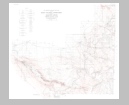
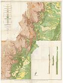
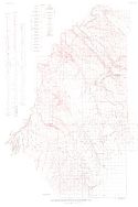
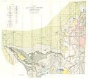
Viewing Options
Main Author:
U.S. Geological Survey
Title/Description:
Topographic Map of Kaiparowits Region, Utah-Arizona
Publication Info:
Washington: Department of the Interior, U.S. Geological Survey, 1931; Professional Paper 164, Plate 1

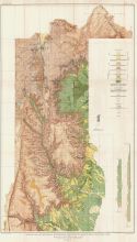
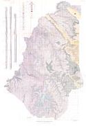
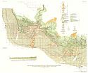
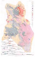
Viewing Options
Main Author:
U.S. Geological Survey
Title/Description:
Geologic Map of Kaiparowits Region, Utah-Arizona
Publication Info:
Washington: Department of the Interior, U.S. Geological Survey, 1931; Professional Paper 164, Plate 2
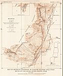
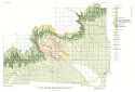
Viewing Options
Main Author:
U.S. Geological Survey
Title/Description:
Map of Southern Extension of Wasatch Plateau Coal Field South of Ivie Creek, Seivier County, Utah
Publication Info:
Washington: Department of the Interior, U.S. Geological Survey, 1931; Bulletin 819 Plate 33
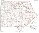
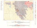
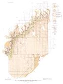
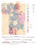
Viewing Options
Main Author:
U.S. Geological Survey
Title/Description:
Preliminary Map Showing Geologic Structure of Parts of Grand and San Juan Counties, Utah
Publication Info:
Washington: Department of the Interior, U.S. Geological Survey, 1931
Viewing Options
Main Author:
U.S. Geological Survey
Title/Description:
Geologic Map and Sections of the Southern Part of the Wasatch Plateau Coal Field, Utah
Publication Info:
Washington: Department of the Interior, U.S. Geological Survey, 1931; Bulletin 819 Plate 32
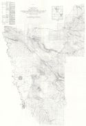
Viewing Options
Main Author:
U.S. Geological Survey
Title/Description:
Geologic Map and Sections of the Northern Part of the Wasatch Plateau Coal Field, Utah
Publication Info:
Washington: Department of the Interior, U.S. Geological Survey, 1931; Bulletin 819 Plate 31
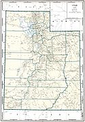
Viewing Options
Main Author:
Geographical Publishing Company
Publication Info:
Chicago: Geographical Publishing Company, 1931; from Commercial Atlas of the World
Viewing Options
Main Author:
U.S. Geological Survey
Title/Description:
Geologic Map and Sections of the Stockton and Fairfield Quadrangles, Utah
Publication Info:
Washington: Department of the Interior, U.S. Geological Survey, 1932; Professional Paper 173, Plate 12

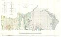
Viewing Options
Main Author:
U.S. Geological Survey
Title/Description:
Map of Escalante Valley, Utah, Showing Topography, Hydrology, and Land Classification
Publication Info:
Washington: Department of the Interior, U.S. Geological Survey, 1932; Water Supply Paper No. 659 Plate 1
Viewing Options
Main Author:
U.S. Geological Survey
Title/Description:
Map Showing Geologic Structure of Moab District, Utah
Publication Info:
Washington: Department of the Interior, U.S. Geological Survey, 1933; Bulletin 841, Plate 2
Viewing Options
Main Author:
U.S. Geological Survey
Title/Description:
Geologic Map of Moab District, Utah
Publication Info:
Washington: Department of the Interior, U.S. Geological Survey, 1933; Bulletin 841, Plate 1
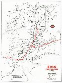
Viewing Options
Main Author:
Continental Oil Company
Title/Description:
Zion National Park, Utah
Publication Info:
Chicago: H.M. Gousha Company, c. 1933
Original Source:
Murray Hudson
Viewing Options
Main Author:
U.S. Geological Survey
Title/Description:
Geologic Map and Sections of Monument Valley - Navajo Mountain Region, San Juan County, Utah
Publication Info:
Washington: Department of the Interior, U.S. Geological Survey, 1935; Bulletin 865, Plate 1

Viewing Options
Main Author:
U.S. Geological Survey
Title/Description:
Reconnaissance Topographic Map of Monument Valley - Navajo Mountain Region, San Juan County, Utah
Publication Info:
Washington: Department of the Interior, U.S. Geological Survey, 1935; Bulletin 865. Plate 2
Viewing Options
Main Author:
U.S. Geological Survey
Title/Description:
Geologic Map Of The Salt Valley Anticline And The Adjacent Areas, Brand County, Utah
Publication Info:
Washington: Department of the Interior, U.S. Geological Survey, 1935; Bulletin 863, Plate 1
Viewing Options
Main Author:
U.S. Geological Survey
Title/Description:
Map and Section of the West Central Part of the Book Cliff Coal Field, Emery and Grand Counties, Utah, Showing geology and Structure
Publication Info:
Washington: Department of the Interior, U.S. Geological Survey, 1935; Bulletin 852, Plate 9

Viewing Options
Main Author:
U.S. Geological Survey
Title/Description:
Map of the Northwestern Part of the Book Cliffs Coal Field, Emery and Carbon Counties, Utah, Showing Geology and Structure
Publication Info:
Washington: Department of the Interior, U.S. Geological Survey, 1935; Bulletin 852, Plate 8
Viewing Options
Main Author:
U.S. Geological Survey
Title/Description:
Map Of The East-central Part Of The Book Cliff Coal Field, Grand County, Utah, Showing Geology And Structure
Publication Info:
Washington: Department of the Interior, U.S. Geological Survey, 1935; Bulletin 852. Plate 10
Viewing Options
Main Author:
U.S. Geological Survey
Title/Description:
Map Of The Northeastern Part Of Book Cliffs Coal Field, Grand County, Utah, Showing Geology And Structure
Publication Info:
Washington: Department of the Interior, U.S. Geological Survey, 1935; Bulletin 852, Plate 11
Viewing Options
Main Author:
U.S. Geological Survey
Title/Description:
Geologic Map And Structure Sections Of Gold Hill And Vicinity, Utah
Publication Info:
Washington: Department of the Interior, U.S. Geological Survey, 1935; Professional Paper 177, Plate 2
Viewing Options
Main Author:
U.S. Geological Survey
Title/Description:
Geologic Map And Sections Of Gold Hill Quadrangle, Utah
Publication Info:
Washington: Department of the Interior, U.S. Geological Survey, 1935; Professional Paper 177, Plate 1