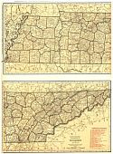
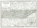
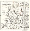
Viewing Options
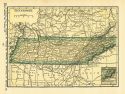
Main Author:
Rand McNally and Company
Title/Description:
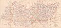
Tennessee
Publication Info:
Chicago: Rand McNally and Company, 1921; from The Commercial Atlas of America
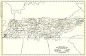
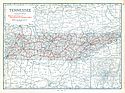
Viewing Options
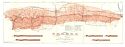
Main Author:
Rand McNally and Company
Title/Description:
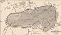
Tennessee - Black and White Mileage Map
Publication Info:
Chicago: Rand McNally and Company, 1921; from The Commercial Atlas of America
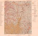
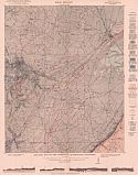
Viewing Options
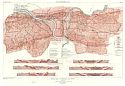
Main Author:
Tennessee Department of Education
Title/Description:
Geologic Map of the Waynesboro Quadrangle
Publication Info:
Nashville: Department of Education, Division of Geology, 1921; Bulletin 26, Plate 1
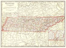
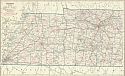
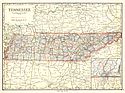
Viewing Options
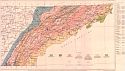
Main Author:
Cram, George F.
Title/Description:
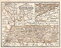
Tennessee
Publication Info:
Chicago: George F. Cram Company, 1921; from Cram's Unrivaled Atlas of the World
Viewing Options
Main Author:
National Map Company
Title/Description:
Tennessee
Publication Info:
Indianapolis: National Map Company, 1921; from Auto Trails and Commercial Survey of the United States
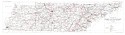
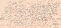
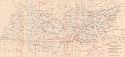
Viewing Options
Main Author:
National Map Company
Title/Description:
Tennessee
Publication Info:
Indianapolis: National Map Company, 1921; from Auto Trails and Commercial Survey of the United States
Western Part
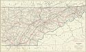
Eastern Part
Main Author:
C.S. Hammond
Title/Description:
Tennessee
Publication Info:
New York: C.S. Hammond and Company, 1922; from The New World Looseleaf Atlas
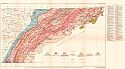
Viewing Options
Main Author:
U.S. Geological Survey
Title/Description:
Map of Part of Western Kentucky and Tennessee Showing Location of Worked Clay Deposits and Prospects
Publication Info:
Washington: Department of the Interior, U.S. Geological Survey, 1922; Bulletin 708 Plate XVII
Viewing Options
Main Author:
U.S. Geological Survey
Title/Description:
Geologic Map of Eastern Tennessee, Showing Location of Manganese Mines and Prospects and Their Relation to the Geologic Formations
Publication Info:
Washington: Department of the Interior, U.S. Geological Survey, 1922; Bulletin 737 Plate 16
Viewing Options
Title/Description:
Archaeological Map of the State of Tennessee
Publication Info:
Washington: Smithsonian Institution, Bureau of American Ethnology, 42nd Annual Report, 1923
Viewing Options
Main Author:
Cram, George F.
Title/Description:
Tennessee
Publication Info:
Chicago: George F. Cram Company, 1923; from Cram's Unrivaled Atlas of the World
Viewing Options
Main Author:
Funk and Wagnalls Company
Title/Description:
Tennessee
Publication Info:
New York: Funk and Wagnalls Company, 1923; from Atlas of the World and Gazetteer
Viewing Options
Main Author:
Tennessee Department of Educations
Title/Description:
Marble Belt of Friendsville and Vicinity
Publication Info:
Nashville: Tennessee Department of Education, Division of Geology, 1924; Plate 2, Bulletin No. 28
Viewing Options
Main Author:
Tennessee Department of Educations
Title/Description:
Marble Belt of Knoxville and Vicinity
Publication Info:
Nashville: Tennessee Department of Education, Division of Geology, 1924; Plate 1, Bulletin No. 28
Viewing Options
Main Author:
Tennessee Department of Educations
Title/Description:
Geologic Map of East Tennessee, Showing Location of Zinc Mines and Prospects and Their Relation to the Geologic Formations
Publication Info:
Nashville: Department of Education, Division of Geology, 1924; Bulletin 31, Plate 1
Viewing Options
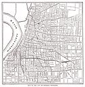
Main Author:
Reynolds, Francis J.
Title/Description:
Memphis
Publication Info:
New York: P.F. Collier and Son Company, 1924; from The New World Atlas and Gazetteer

Viewing Options
Main Author:
Tennessee Department of Educations
Title/Description:
Tennessee State Coal Land
Publication Info:
Nashville: Department of Education, Division of Geology, 1925; Bulletin 33c, Plate 1
Viewing Options
Main Author:
Tennessee Department of Educations
Title/Description:
Geologic map of the Crossville quadrangle, Tennessee
Publication Info:
Nashville: Department of Education, Division of Geology, 1925; Bulletin 33D, Plate 1
Viewing Options
Main Author:
Tennessee Department of Educations
Title/Description:
Map of Tennessee and Parts of Adjacent States Showing Rainfall Stations and Isohyetal Lines
Publication Info:
Nashville: Department of Education, Division of Geology, 1925; Bulletin 34, Plate 1-B
Viewing Options
Main Author:
Tennessee Department of Educations
Title/Description:
Map of Tennessee and Parts of Adjoining States Showing Power Generating Plants and Transmission Lines
Publication Info:
Nashville: Department of Education, Division of Geology, 1925; Bulletin 34, Plate 1-C
Viewing Options
Main Author:
Tennessee Department of Educations
Title/Description:
Map of Tennessee and Parts of Adjoining States Showing Principal River Systems and Location of Gaging Stations
Publication Info:
Nashville: Department of Education. Division of Geology, 1925; Bulletin 34, Plate 1-A
Viewing Options
Main Author:
Tennessee Department of Educations
Title/Description:
Map of the proposed Great Smoky Mountains National Park
Publication Info:
Nashville: Department of Education, Division of Geology, 1925; Bulletin 36, Plate 15
Viewing Options
Main Author:
Clason Map Company
Title/Description:
Midget Mileage Map of the Best Roads in Tennessee
Publication Info:
Denver: Clason Map Company