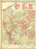
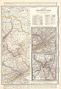
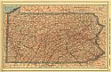
Eastern Section
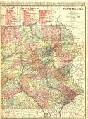
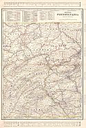
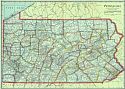
Western Section
Main Author:
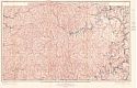
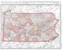
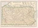
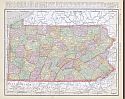
Rand McNally and Company
Title/Description:
Pennsylvania
Publication Info:
Chicago: Rand McNally and Company, 1906; from The Business Atlas and Shippers Guide
Viewing Options
Main Author:
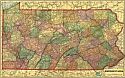
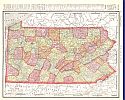
C.S. Hammond and Company
Title/Description:
Pennsylvania
Publication Info:
New York: C.S. Hammond and Company, 1906; from The Pictorial Atlas of the World
Viewing Options
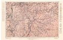
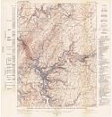
Main Author:
U.S. Geological Survey
Title/Description:
Map showing Structure and Economic Geology of Kittanning and Rural Valley Quadrangles
Publication Info:
Washington: Department of the Interior, U.S. Geological Survey, 1906; Bulletin 279 Plate XI
Viewing Options
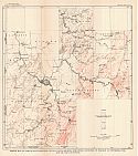
Main Author:
U.S. Geological Survey
Title/Description:
Map of Greene County, PA Showing Oil and Gas Wells, Structure Contours and Coal Outcrops
Publication Info:
Washington: Department of the Interior, U.S. Geological Survey, 1906; Bulletin 304 Plate I
Viewing Options
Viewing Options
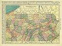
Main Author:
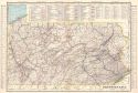
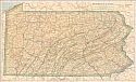
Cram, George F.
Title/Description:
Pennsylvania
Publication Info:
Chicago: George F. Cram for A. A. Grant, Toronto, Ont., 1906; from Grant's Bankers and Brokers Railroad System Atlas
Viewing Options
Main Author:
Cram, George F.
Title/Description:
Pennsylvania
Publication Info:
Chicago: George F. Cram for A. A. Grant, Toronto, Ont., 1906; from Grant's Bankers and Brokers Railroad System Atlas
Viewing Options
Main Author:
Rand McNally and Company
Title/Description:
Pennsylvania
Publication Info:
Chicago: Rand McNally and Company, 1906; from The World and its Peoples
Viewing Options
Main Author:
Cram, George F.
Title/Description:
Pennsylvania
Publication Info:
Chicago: George F. Cram, 1907; from Cram's Standard American Atlas
Viewing Options
Main Author:
P.F. Collier and Son
Title/Description:
Pennsylvania
Publication Info:
New York: P.F. Collier and Son, 1907; from The New Encyclopedic Atlas and Gazetteer of the World

Viewing Options
Main Author:
The Crowell Publishing Company
Title/Description:
Pennsylvania
Publication Info:
New York: The Crowell Publishing Co., 1908; from The Twentieth Century Peerless Atlas
Viewing Options
Main Author:
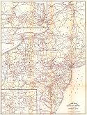
The International Text Book Company
Title/Description:
Railway Mail Service
Publication Info:
Scranton, PA: International Correspondence Schools, 1908
Viewing Options
Main Author:
Hammond, C.S.
Title/Description:
Pennsylvania
Publication Info:
New York: C.S. Hammond & Co. 1908; from Hammond's Handy Atlas of the World
Viewing Options
Main Author:
Rand McNally and Company
Title/Description:
Pennsylvania
Publication Info:
Chicago: Rand McNally and Company, 1908; from The New Ideal State and County Survey and Atlas
Viewing Options
Main Author:
Patten, William and J.E. Homas
Title/Description:
Pennsylvania
Publication Info:
New York: P.F. Collier and Son, 1909; from The New Encyclopedic Atlas and Gazetteer of the World
Viewing Options
Main Author:
Cram, George F.
Title/Description:
Pennsylvania
Publication Info:
Chicago: George F. Cram, c.1909; from The Heart of Our Country
Viewing Options
Main Author:
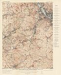
U.S. Geological Survey
Title/Description:
Economic and Structural Map of the Johnstown Quadrangle, Pennsylvania
Publication Info:
Washington: Department of the Interior, U.S. Geological Survey, 1910; Bulletin 447 Plate I
Viewing Options
Main Author:
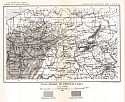
U.S. Geological Survey
Title/Description:
Sketch Map of Part of Southwestern Pennsylvania Showing Structure Contours on Horizon of Pittsburg Coal and Oil and Gas Fields
Publication Info:
Washington: Department of the Interior, U.S. Geological Survey, 1910; Bulletin 456 Plate IV
Viewing Options
Main Author:
U.S. Geological Survey
Title/Description:
Map of the Oil and Gas Fields of the Carnegie Quadrangle, Pennsylvania Showing Structure, Producing Areas, etc., of the Oil Sands
Publication Info:
Washington: Department of the Interior, U.S. Geological Survey, 1910; Bulletin 456 Plate V

Viewing Options
Main Author:
U.S. Geological Survey
Title/Description:
Reconnaissance Map of the Oil and Gas Pools of the Foxburg Quadrangle, Pennsylvania
Publication Info:
Washington: Department of the Interior, U.S. Geological Survey, 1910; Bulletin 454 Plate X
Viewing Options
Main Author:
U.S. Geological Survey
Title/Description:
Coal Fields of Pennsylvania
Publication Info:
Washington: Department of the Interior, U.S. Geological Survey, 1910; from Mineral Resources of the United States Part II Plate XI
Viewing Options
Main Author:
Rand McNally and Company
Title/Description:
Pennsylvania
Publication Info:
Chicago: Rand McNally and Company, 1910; from New Ideal State and County Survey

