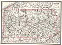
Viewing Options
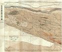
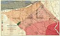
Main Author:
Ashburner, Charles A.
Title/Description:
Anthracite Coal Fields of Pennsylvania and Adjoining Counties, Sheet 1
Publication Info:
Harrisburg: Second Geological Survey of Pennsylvania, 1886; from the Annual Report of 1886
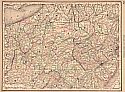
Viewing Options
Main Author:
Ashburner, Charles A.
Title/Description:
Anthracite Coal Fields of , Sheet 2
Publication Info:
Harrisburg: Second Geological Survey of Pennsylvania, 1886; from the Annual Report of 1886
Viewing Options
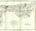
Main Author:
Ashburner, Charles A.
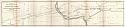
Title/Description:
Northern Anthracite Field, Mine Sheet No. 1
Publication Info:
Harrisburg: Second Geological Survey of Pennsylvania, 1886; from the Annual Report of 1886
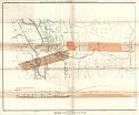
Viewing Options
Main Author:
Ashburner, Charles A.
Title/Description:
Northern Anthracite Field, Mine Sheet No. 2
Publication Info:
Harrisburg: Second Geological Survey of Pennsylvania, 1886; from the Annual Report of 1886
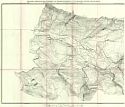
Viewing Options
Main Author:
Ashburner, Charles A.
Title/Description:
Topographic Map in Ten Foot Contour Curve Lines of a Portion of the Lackawanna Valley between Scranton and Carbondale, Sheet 1
Publication Info:
Harrisburg: Second Geological Survey of Pennsylvania, 1886; from the Annual Report of 1886
Viewing Options
Main Author:
Ashburner, Charles A.
Title/Description:
Topographic Map in Ten Foot Contour Curve Lines of a Portion of the Lackawanna Valley between Scranton and Carbondale, Sheet 2
Publication Info:
Harrisburg: Second Geological Survey of Pennsylvania, 1886; from the Annual Report of 1886
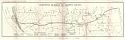
Viewing Options
Main Author:
Second Geological Survey of Pennsylvania
Title/Description:
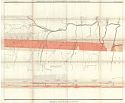
Map and Section Along the Lehigh River, Sheet 1
Publication Info:
Harrisburg: Second Geological Survey of Pennsylvania, 1886; from the Annual Report of 1886
Viewing Options
Main Author:
Second Geological Survey of Pennsylvania
Title/Description:
Map and Section Along the Lehigh River, Sheet 2
Publication Info:
Harrisburg: Second Geological Survey of Pennsylvania, 1886; from the Annual Report of 1886
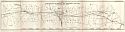
Viewing Options
Main Author:
Second Geological Survey of Pennsylvania
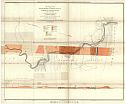
Title/Description:
Map and Section along the Lehigh River, Sheet 3
Publication Info:
Harrisburg: Second Geological Survey of Pennsylvania, 1886; from the Annual Report of 1886
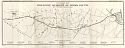
Viewing Options
Main Author:
Second Geological Survey of Pennsylvania
Title/Description:
Map Showing the Outcrop and Mine Openings on the Lehigh Paint Bed
Publication Info:
Harrisburg: Second Geological Survey of Pennsylvania, 1886; from the Annual Report of 1886
Viewing Options
Main Author:
d'Invilliers, E.V.
Title/Description:
Reference Map of the Iron Ore Mines and Limestone Quarries of Franklin County
Publication Info:
Harrisburg: Second Geological Survey of Pennsylvania, 1886; from the Annual Report of 1886
Viewing Options
Main Author:
d'Invilliers, E.V.
Title/Description:
Reference Map of the Iron Ore Mines and Limestone Quarries of Cumberland County
Publication Info:
Harrisburg: Second Geological Survey of Pennsylvania, 1886; from the Annual Report of 1886
Viewing Options
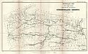
Main Author:
d'Invilliers, E.V.
Title/Description:
Reference Map of the Iron Ore Mines and Limestone Quarries of Dauphin County
Publication Info:
Harrisburg: Second Geological Survey of Pennsylvania, 1886; from the Annual Report of 1886
Viewing Options
Main Author:
d'Invilliers, E.V.
Title/Description:
Reference Map of the Iron Ore Mines and Limestone Quarries of Lebanon County
Publication Info:
Harrisburg: Second Geological Survey of Pennsylvania, 1886; from the Annual Report of 1886
Viewing Options
Main Author:
d'Invilliers, E.V.
Title/Description:
Reference Map of the Iron Ore Mines and Limestone Quarries of Berks County
Publication Info:
Harrisburg: Second Geological Survey of Pennsylvania, 1886; from the Annual Report of 1886
Viewing Options
Main Author:
Rand, Theodore D.
Title/Description:
A Geological Map of the Serpentine Ranges of Radnor Township, Delaware Co. and L. Merion, Montgomery Co.
Publication Info:
Harrisburg: Second Geological Survey of Pennsylvania, 1886; from the Annual Report of 1886
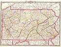
Viewing Options
Title/Description:
Gray's New Map of Pennsylvania
Publication Info:
Philadelphia: Stedman and Brown, 1886; from The National Atlas
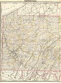
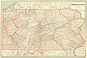
Viewing Options
Main Author:
Cram, George F.
Title/Description:
Pennsylvania
Publication Info:
Chicago: George F. Cram, 1886; from Cram's Unrivaled Family Atlas of the World
Viewing Options
Main Author:
d'Invilliers, Edward V.
Title/Description:
Map of the Cornwall Iron Ore Mines, in Lebanon County, Penna.
Publication Info:
St. Louis: Transactions of the American Institute of Mining Engineers, Pittsburgh Meeting, February 1886
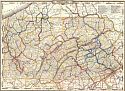
Viewing Options
Main Author:
Monteith, James
Title/Description:
Pennsylvania and New Jersey
Publication Info:
New York: A.S. Barnes and Company, 1886; from Barnes' Complete Geography
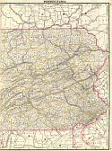
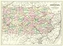
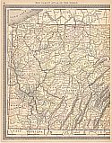
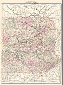
Viewing Options
Main Author:
Cram, George F.
Title/Description:
Pennsylvania
Publication Info:
Chicago: George F. Cram, 1887
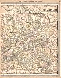
Viewing Options
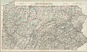
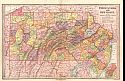
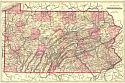
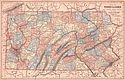
Main Author:
Mitchell, S. Augustus
Title/Description:
County Map of Pennsylvania
Publication Info:
Philadelphia: William M. Bradley & Bro., 1888; from Mitchell's New General Atlas
Viewing Options
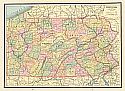
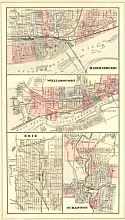
Main Author:
Mitchell, S. Augustus
Title/Description:
Harrisburg, Williamsport, Erie, Scranton
Publication Info:
Philadelphia: William M. Bradley & Bro., 1888; from Mitchell's New General Atlas
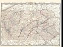
Viewing Options
Title/Description:
Pennsylvania
Publication Info:
New York: A. A. Grant, 1887; from Grant's Standard American Atlas of the World
Viewing Options
Viewing Options
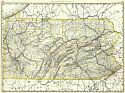
Main Author:
Cram, George F
Title/Description:
Western Half of Pennsylvania
Publication Info:
Chicago: George F Cram, 1887, from Cram's Banker and Brokers Railroad Atlas
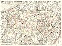
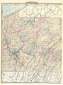
Viewing Options
Main Author:
Cram, George F
Title/Description:
Pennsylvania
Publication Info:
Chicago: George F Cram, 1887, from Cram's Banker and Brokers Railroad Atlas
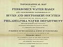
Main Author:
Geological Survey of Pennsylvania
Title/Description:
Topographical Maps of the Perkiomen Water Basin and neighboring watersheds in Bucks and Montgomery Counties
Publication Info:
Harrisburg: Geological Survey of Pennsylvania, 1885
Viewing Options
Main Author:
People's Publishing Co.
Title/Description:
Pennsylvania
Publication Info:
Rochester: W.H. Stewart & Co., 1888; from The Peoples' Illustrated & Descriptive Family Atlas of the World
Viewing Options
Main Author:
Rand McNally & Co.
Title/Description:
Pennsylvania
Publication Info:
Chicago: Rand McNally & Co., 1888; from Rand McNally's Standard Atlas of the World
Viewing Options
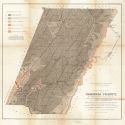
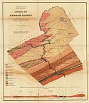
Main Author:
Fulton, John
Title/Description:
Geological Map of Cambria County
Publication Info:
Harrisburg: Geological Survey of Pennsylvania, 1888
Viewing Options
Main Author:
Harden, Edward B.
Title/Description:
Geological Map of Somerset County
Publication Info:
Harrisburg: Geological Survey of Pennsylvania, 1888
Viewing Options
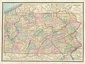
Main Author:
Johnson, Alvin J.
Title/Description:
Map of Pennsylvania
Publication Info:
New York: A.J. Johnson, 1889; Drawn and Engraved on Copper-Plate Expressly for Johnson's Cyclopedia
Viewing Options
Main Author:
Rand McNally and Company
Title/Description:
Pennsylvania
Publication Info:
Chicago: Rand McNally and Co., 1889; from The Enlarged Business Atlas and Shippers Guide
Viewing Options
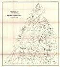
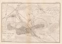
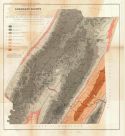
Main Author:
Lesley, J.P., I.C. White, Arthur Winslow and others
Title/Description:
Geological Map of Carbon County
Publication Info:
Harrisburg: Second Geological Survey of Pennsylvania, 1889
Viewing Options
Main Author:
Mast, Crowell and Kirkpatrick
Title/Description:
Map of Pennsylvania
Publication Info:
Springfield, Ohio: Mast, Crowell and Kirkpatrick, 1889; from Peerless Atlas of the World
Viewing Options
Main Author:
Cram, George F.
Title/Description:
Pennsylvania
Publication Info:
Chicago: George F. Cram, 1890
Viewing Options
Viewing Options
Main Author:
Rand McNally & Co.
Title/Description:
Map of Pennsylvania
Publication Info:
Chicago: Rand McNally & Co., 1890; from Rand McNally & Co.'s Family Atlas of the World
Viewing Options
Main Author:
Alden, John B.
Title/Description:
Pennsylvania
Publication Info:
New York: John B. Alden, 1890
Viewing Options
Main Author:
Walker, Henry B.
Title/Description:
Pennsylvania - Eastern Half
Publication Info:
Philadelphia: H.B. Walker, 1890; from Walker's International Atlas
Viewing Options
Main Author:
Walker, Henry B.
Title/Description:
Pennsylvania - Western Half
Publication Info:
Philadelphia: H.B. Walker1890; from Walker's International Atlas
Viewing Options
Main Author:
Walker, Henry B.
Title/Description:
Pennsylvania
Publication Info:
Philadelphia: H.B. Walker1890; from Walker's International Atlas