Historical Maps of Other Southeastern States

Selected Oregon Out-of-Print Quadrangles
USGS or Army Map Service

Next Page

  Main Author:   Freemont, John Charles
  Title/Description:   Beer Springs
  Publication Info:   Washington, D.C.: Gales and Seaton, 1845; from Report of the Exploring Expedition to the Rocky Mountains in the Year 1842, and to Oregon and North California in the Years 1843-44
  Date:   1845
  Scale:   1:63,360
  Original Source:   Courtesy of Murray Hudson, Halls, Tennessee
Viewing options:


  Main Author:   Freemont, John Charles
  Title/Description:   [Beer River from Beer Spring to Muddy Fork]
  Publication Info:   Washington, D.C.: Gales and Seaton, 1845; from Report of the Exploring Expedition to the Rocky Mountains in the Year 1842, and to Oregon and North California in the Years 1843-44
  Date:   1845
  Scale:   1:285,120
  Original Source:   Courtesy of Murray Hudson, Halls, Tennessee
Viewing options:


  Main Author:    
  Title/Description:   The Oregon County. After the Treaty with Great Britain 1846. Occupied Jointly by Great Britain and United States, 1818-1846
  Publication Info:   New York: 1846
  Date:   1846
  Scale:   1:8,500,000
  Original Source:   Courtesy of Murray Hudson, Halls, Tennessee
Viewing options:


  Main Author:   Yeager, Edward
  Title/Description:   Map of the Oregon Territory from the Best Authorities. 1849
  Publication Info:   Washington, D.C.: U.S. Exploring Expedition, 1849
  Date:   1849
  Scale:   1:6,672,000
  Original Source:   Courtesy of Murray Hudson, Halls, Tennessee
Viewing options:


  Main Author:   Gardiner, C.K.
  Title/Description:   Map of the Oregon Territory West of the Cascade Mountains
  Publication Info:   Salem, OT: Surveyor General's Office, 1855; Sen. Ex. Doc. No.1 34th Cong. 1st Sess.
  Date:   1855
  Scale:   1:1,140,000
  Original Source:   Courtesy of Murray Hudson, Halls, Tennessee
Viewing options:


  Main Author:   Abbott, Lieut. H. and Lieut. R.S. Williamson
  Title/Description:   Map No. 2. From the Northern Boundary of Califorina to the Columbia River
  Publication Info:   Washington, D.C.: War Department, 1855; explorations and surveys for a Pacific railroad route
  Date:   1855
  Scale:   1:760,000
  Original Source:   Courtesy of Murray Hudson, Halls, Tennessee
Viewing options:


  Main Author:   Pengrie, B.J.
  Title/Description:   
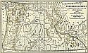
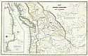
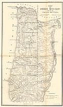
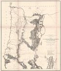
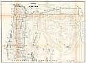
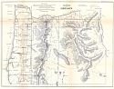
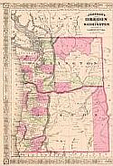
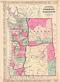
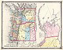
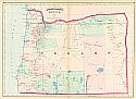
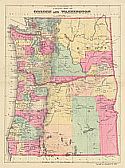
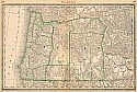
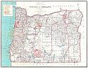
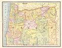
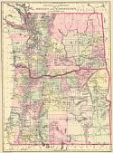
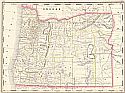
A Diagram of Public Surveys in Oregon
  Publication Info:   Washington, D.C.: U.S. Department of the Interior, General Land Office, 1858
  Date:   1858
  Scale:   1:1,140,000
  Original Source:   Courtesy of Murray Hudson, Halls, Tennessee
Viewing options:


  Main Author:   Pengre, B.J.
  Title/Description:   A Diagram of Oregon
  Publication Info:   Eugene City: Surveyor General's Office, 1861
  Date:   1861
  Scale:   1:1,140,000
  Original Source:   Courtesy of Murray Hudson, Halls, Tennessee
Viewing options:


  Main Author:   Johnson, A.J.
  Title/Description:   Johnson's Oregon and Washington
  Publication Info:   New York: A.J. Johnson, c.1865
  Date:   1865
  Scale:   1:2,534,000
  Original Source:   Courtesy of Murray Hudson, Halls, Tennessee
Viewing options:


  Main Author:   Applegate, E.L.
  Title/Description:   Oregon
  Publication Info:   Washington, D.C.: Department of the Interior, General Land Office, 1866
  Date:   1866
  Scale:   1:1,140,000
  Original Source:   Courtesy of Murray Hudson, Halls, Tennessee
Viewing options:


  Main Author:   Johnson, Alvin J.
  Title/Description:   Johnson's Oregon and Washington
  Publication Info:   New York: A.J. Johnson, 1868
  Date:   1868
  Scale:   1:2,534,000
  Original Source:   Courtesy of Murray Hudson, Halls, Tennessee
Viewing options:


  Main Author:   unknown
  Title/Description:   Map of Woodlawn. Situated in Section No. 14, Township 1 North, Range 1 East of the Willamette Meridian
  Publication Info:   [Portland]: c.1870; with promotional description
  Date:   1870
  Scale:   1:3,300
  Original Source:   Courtesy of Murray Hudson, Halls, Tennessee
Viewing options:


  Main Author:   Lloyd, H.H. and Company
  Title/Description:   County Map of Oregon, Washington - Territory of Alaska
  Publication Info:   New York: Warner & Beers, c.1873; from H.H. Lloyd & Co.'s Atlas of the United States
  Date:   1873
  Scale:   1:3,295,000
  Original Source:   Courtesy of Murray Hudson, Halls, Tennessee
Viewing options:


  Main Author:   Asher & Adams
  Title/Description:   Asher & Adams' Oregon
  Publication Info:   New York: Asher & Adams, 1873
  Date:   1873
  Scale:   1:1,267,000
  Original Source:   Courtesy of Murray Hudson, Halls, Tennessee
Viewing options:


  Main Author:   Gray, Frank A.
  Title/Description:   Oregon and Washington
  Publication Info:   Philadelphia: Frank A. Gray, 1878
  Date:   1878
  Scale:   1:2,534,000
  Original Source:   Courtesy of Murray Hudson, Halls, Tennessee
Viewing options:


  Main Author:   Bradley, William M.
  Title/Description:   County Map of Oregon and Washington
  Publication Info:   Philadelphia: Bradely & Co., c.1881; a Mitchell map reissued in a Bradley atlas
  Date:   1881
  Scale:   1:3,295,000
  Original Source:   Courtesy of Murray Hudson, Halls, Tennessee
Viewing options:


  Main Author:   Hardesty, H.H.
  Title/Description:   Map of Oregon
  Publication Info:   Chicago: H.H. Hardesty, 1882
  Date:   1882
  Scale:   1:1,901,000
  Original Source:   Courtesy of Murray Hudson, Halls, Tennessee
Viewing options:


  Main Author:   Hardesty, H.H.
  Title/Description:   Map of Oregon
  Publication Info:  

Chicago: Rand McNally & Co., 1883; map from a Hardesty Atlas

  Date:   1883
  Scale:   1:1,901,000
  Original Source:   Courtesy of Murray Hudson, Halls, Tennessee
Viewing options:


  Main Author:   Cram, George F.
  Title/Description:   Oregon
  Publication Info:   Chicago: George F. Cram, 1883
  Date:  

1883

  Scale:   1:2,281,000
  Original Source:   Courtesy of Murray Hudson, Halls, Tennessee
Viewing options:


  Main Author:   Cram, George F.
  Title/Description:   New Rail Road and County Map of Oregon and Washington Territory
  Publication Info:   Chicago: George F. Cram, 1883
  Date:  

1883

  Scale:   1:2,281,000
  Original Source:   Courtesy of Murray Hudson, Halls, Tennessee
Viewing options:


  Main Author:   Hardesty, H.H.
  Title/Description:   Map of Oregon
  Publication Info:   New York: H.H. Hardesty & Compay, 1883; from Hardesty's Historical and Geographical Encyclopedia
  Date:   1883
  Scale:   1:1,520,000
  Original Source:   Courtesy of Murray Hudson, Halls, Tennessee
Viewing options:


  Main Author:    
  Title/Description:   Oregon and Washington
  Publication Info:   Philadelphia: O.W. Gray and Son, 1883; from The National Atlas
  Date:   1883
  Scale:   1:2,534,400
  Original Source:   Courtesy of Murray Hudson, Halls, Tennessee
Viewing options:


  Main Author:   Rand McNally and Co.
  Title/Description:   Oregon
  Publication Info:   Chicago: Rand McNally & Co., c.1884; from Rand McNally & Co.'s Indexed Atlas of the World
  Date:   1884
  Scale:   1:1,901,000
  Original Source:   Courtesy of Murray Hudson, Halls, Tennessee
Viewing options:


  Main Author:   Strum, C.P.
  Title/Description:   State of Oregon
  Publication Info:   Washington: Department of the Interior, General Land Office, 1884
  Date:   1884
  Scale:   1:950,000
  Original Source:   Courtesy of Murray Hudson, Halls, Tennessee
Viewing options:


  Main Author:   Hardesty, H.H.
  Title/Description:   Map of Oregon
  Publication Info:   Chicago: Rand McNally & Co., 1884
  Date:   1884
  Scale:   1:1,521,000
  Original Source:   Courtesy of Murray Hudson, Halls, Tennessee
Viewing options:


  Main Author:   Strum, G.P.
  Title/Description:   State of Oregon
  Publication Info:   Washington, D.C.: United States Department of the Interior, General Land Office, 1884
  Date:   1884
  Scale:   1:950,000
  Original Source:   Courtesy of Murray Hudson, Halls, Tennessee
Viewing options:


  Main Author:   Mitchell, S. Augustus
  Title/Description:   County and Township Map of Oregon and Washington
  Publication Info:   Philadelphia: William M. Bradley and Bro., 1884; from Mitchell's Atlas of the World
  Date:   1884
  Scale:   1:1,774,080
  Original Source:   Courtesy of Murray Hudson, Halls, Tennessee
Viewing options:


  Main Author:   Cram, George F.
  Title/Description:   Oregon
  Publication Info:   Chicago: George F. Cram, 1885
  Date:   1885
  Scale:   1:2,281,000
  Original Source:   Courtesy of Murray Hudson, Halls, Tennessee
Viewing options:


  Main Author:    
  Title/Description:   Orgeon
  Publication Info:   Chicago: Encyclopedia Britannica, c.1885
  Date:   1885
  Scale:   1:2,693,000
  Original Source:   Courtesy of Murray Hudson, Halls, Tennessee
Viewing options:


  Main Author:   Watson, Gaylord
  Title/Description:   Watson's Atlas Map of Oregon
  Publication Info:   New York: Gaylord Watson, 1886
  Date:   1886
  Scale:   1:2,218,000
  Original Source:   University of Alabama Map Library
Viewing options:


  Main Author:   Cram, George F.
  Title/Description:   Oregon
  Publication Info:   Chicago: George F. Cram, c. 1886; For Gaskell's Atlas of the World
  Date:   1886
  Scale:   1:2,281,000
  Original Source:   Courtesy of Murray Hudson, Halls, Tennessee
Viewing options:
 

  Main Author:   Bradley, William M.
  Title/Description:   County and Township Map of Oregon and Washington
  Publication Info:   Philadelphia: W.M. Bradley & Bro., 1887
  Date:   1887
  Scale:   1:1,774,000
  Original Source:   Courtesy of Murray Hudson, Halls, Tennessee
Viewing options:


  Main Author:   Cram, George F.
  Title/Description:   Oregon
  Publication Info:   Chicago: George F. Cram, 1887
  Date:   1887
  Scale:   1:2,344,000
  Original Source:   Courtesy of Murray Hudson, Halls, Tennessee
Viewing options:


  Main Author:   Cram, George F.
  Title/Description:   Railroad and County Map of Oregon
  Publication Info:   Chicago: A.A. Grant, 1887; from Grant's Standard American Atlas of the World
  Date:   1887
  Scale:   1:1,394,000
  Original Source:   Courtesy of Murray Hudson, Halls, Tennessee
Viewing options:
 

Next Page