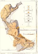
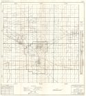
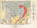
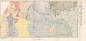
Viewing Options
Main Author:
U.S. Geological Survey
Title/Description:
Geologic Map and Sections of the Area including the No. 3 Reservoir site of the Carlsbad irrigation project, New Mexico
Publication Info:
Washington: Department of the Interior, U.S. Geological Survey, 1926; Water Supply Paper No. 580 Plate 1
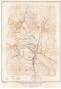
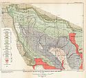
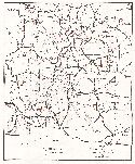
Viewing Options
Main Author:
U.S. Geological Survey
Title/Description:
Map Showing Outcrops of Faults and Accompanying Veins in the Mogollon Mining District, Catron County, New Mexico
Publication Info:
Washington: Department of the Interior, U.S. Geological Survey, 1927; Bulletin 787 Plate 11
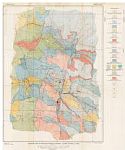
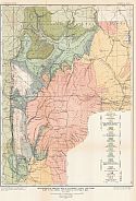
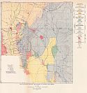
Viewing Options
Main Author:
U.S. Geological Survey
Title/Description:
Geologic Map of Mogollon Mining District, Catron County, New Mexico
Publication Info:
Washington: Department of the Interior, U.S. Geological Survey, 1927; Bulletin 787 Plate 1
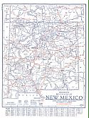
Viewing Options
Main Author:
Clason Map Company
Title/Description:
Best Roads of New Mexico
Publication Info:
Chicago: Clason Map Company, c. 1927; from Clason's Touring Atlas
Viewing Options
Main Author:
Dobbin, C.E. and Foster Morrell
Title/Description:
Map of Artesia Oil Field, Eddy County, New Mexico
Publication Info:
Socorro: New Mexico School of Mines, 1928; Bulletin No. 9
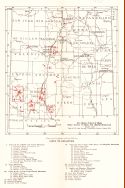
Viewing Options
Main Author:
New Mexico School of Mines
Title/Description:
Fluorspar Deposits of New Mexico
Publication Info:
Socorro: New Mexico School of Mines, 1928; Bulletin No. 9
Viewing Options
Main Author:
U.S. Geological Survey
Title/Description:
Geologic Map of Part of the Sacramento Mountains, Otero County, New Mexico
Publication Info:
Washington: Department of the Interior, U.S. Geological Survey, 1929; Bulletin 794 Plate 44
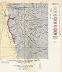
Viewing Options
Main Author:
U.S. Geological Survey
Title/Description:
Reconnaissance Geologic Map of the San Andres Mountains, New Mexico
Publication Info:
Washington: Department of the Interior, U.S. Geological Survey, 1929; Bulletin 794 Plate 40
Viewing Options
Main Author:
U.S. Geological Survey
Title/Description:
Reconnaissance Geologic Map of Oscura Mountains, South End of Chupadera Mesa, and Northern Part of Tularosa Valley in Socorro and Lincoln Counties, New Mexico
Publication Info:
Washington: Department of the Interior, U.S. Geological Survey, 1929; Bulletin 794 Plate 42
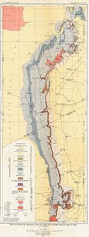
Viewing Options
Main Author:
U.S. Geological Survey
Title/Description:
Reconnaissance Geologic Map of Nacimiento Uplift and Chama Basin in Rio Arriba and Sandoval Counties, New Mexico
Publication Info:
Washington: Department of the Interior, U.S. Geological Survey, 1929; Bulletin 794 Plate 37
Viewing Options
Main Author:
U.S. Geological Survey
Title/Description:
Reconnaissance Geologic Map of Zuni Mountain Region, New Mexico
Publication Info:
Washington: Department of the Interior, U.S. Geological Survey, 1929; Bulletin 794 Plate 33
Viewing Options
Main Author:
U.S. Geological Survey
Title/Description:
Geologic Reconnaissance Map of Parts of Valencia, Socorro, and Catron Counties, New Mexico
Publication Info:
Washington: Department of the Interior, U.S. Geological Survey, 1929; Bulletin 794 Plate 26
Viewing Options
Main Author:
U.S. Geological Survey
Title/Description:
Geologic Reconnaissance Map of North Central, New Mexico
Publication Info:
Washington: Department of the Interior, U.S. Geological Survey, 1929; Bulletin 794 Plate 24
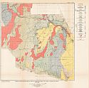
Viewing Options
Main Author:
U.S. Geological Survey
Title/Description:
Reconnaissance Geologic Map of part of central New Mexico
Publication Info:
Washington: Department of the Interior, U.S. Geological Survey, 1929; Bulletin 794 Plate 17
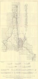
Viewing Options
Main Author:
New Mexico State Highway Commission
Title/Description:
Road Map of New Mexico
Publication Info:
Santa Fe: New Mexico State Highway Commission, 1929
Original Source:
Murray Hudson
Viewing Options
Main Author:
U.S. Geological Survey
Title/Description:
Geologic Map and Sections of the Western Part of Sandoval County, New Mexico
Publication Info:
Washington: Department of the Interior, U.S. Geological Survey, 1930; Water Supply Paper No. 620 Plate 1

