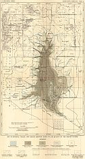
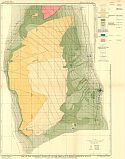
Viewing Options
Main Author:
U.S. Geological Survey
Title/Description:
Map of Estancia Valley, New Mexico, Showing Depth To and Quality of the Ground Waters
Publication Info:
Washington: Department of the Interior, U.S. Geological Survey, 1911; Water Supply Paper No. 275 Plate 11
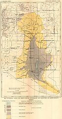
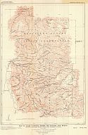
Viewing Options
Main Author:
U.S. Geological Survey
Title/Description:
Map of Estancia Valley, New Mexico, Showing Physiography and Pleistocene and Recent Geology
Publication Info:
Washington: Department of the Interior, U.S. Geological Survey, 1911; Water Supply Paper No. 275 Plate 1
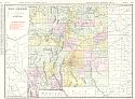
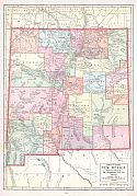
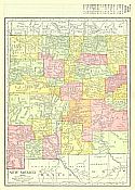
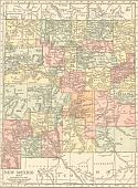
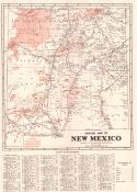
Viewing Options
Main Author:
Rand McNally and Company
Title/Description:
New Mexico
Publication Info:
Chicago: Rand McNally and Company, 1911; from The Commercial Atlas of America
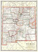
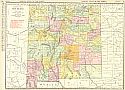
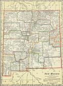
Viewing Options
Main Author:
Cram, George F.
Title/Description:
New Mexico
Publication Info:
Chicago: George F. Cram, 1911; from Cram's Unrivaled Atlas of the World
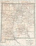
Viewing Options
Main Author:
Ravenstein, E.G.
Title/Description:
New Mexico
Publication Info:
Chicago: The Reilly and Britton Company, 1911; from The New Census Atlas of the World
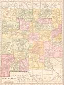
Viewing Options
Main Author:
Rand McNally & Company
Title/Description:
New Mexico
Publication Info:
Chicago: Rand McNally & Co., 1912; from Rand McNally's Library Atlas of the World
Viewing Options
Main Author:
Rand McNally and Company
Title/Description:
New Mexico
Publication Info:
Chicago: Rand McNally and Company, 1912; from The Rand McNally Imperial Atlas of the World
Viewing Options
Main Author:
U.S. Geological Survey
Title/Description:
Map of New Mexico, Showing Locations of Mining Districts
Publication Info:
Washington: Department of the Interior, U.S. Geological Survey, 1912; Bulletin 507; Plate X
Viewing Options
Main Author:
Rand McNally & Company
Title/Description:
Rand McNally's New Map of New Mexico
Publication Info:
Chicago: Rand McNally & Co., 1913; from the Rand McNally Banker's Directory and List of Attorneys, 76th Edition
Viewing Options
Main Author:
Cram, George F.
Title/Description:
New Mexico
Publication Info:
Chicago: George F. Cram, 1913; from Cram's Unrivaled Atlas of the World
Viewing Options
Main Author:
Reynolds, Francis J.
Title/Description:
New Mexico
Publication Info:
New York: P.F. Collier and Son, 1914; from The New Encyclopedic Atlas and Gazetteer of the World
Viewing Options
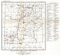
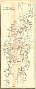
Main Author:
U.S. Geological Survey
Title/Description:
Map of Tularosa Basin showing principal roads and watering places
Publication Info:
Washington: Department of the Interior, U.S. Geological Survey, 1914; Water Supply Paper No. 343 Plate 1
Viewing Options
Main Author:
U.S. Geological Survey
Title/Description:
Map of the Principal Shallow Water Area of Tularosa Basin, New Mexico showing geologic formations, underground and water and vegetation
Publication Info:
Washington: Department of the Interior, U.S. Geological Survey, 1914; Water Supply Paper No. 343 Plate 2
Viewing Options
Main Author:
U.S. Geological Survey
Title/Description:
Map of Alamo National Forest and Vicinity, New Mexico showing drainage basins, roads and watering places
Publication Info:
Washington: Department of the Interior, U.S. Geological Survey, 1914; Water Supply Paper No. 343 Plate 3
Viewing Options
Main Author:
Rand McNally and Company
Title/Description:
New Mexico
Publication Info:
Chicago: Rand McNally and Company, 1915; from The Ideal Atlas of the World
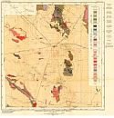
Viewing Options
Main Author:
U.S. Geological Survey
Title/Description:
Geologic Map of Luna County, New Mexico
Publication Info:
Washington: Department of the Interior, U.S. Geological Survey, 1915; Bulletin 618 Plate I
Viewing Options
Main Author:
New Mexico School of Mines
Title/Description:
Mining Map of New Mexico
Publication Info:
Socorro: New Mexico School of Mines, 1915; Bulletin No. 1

