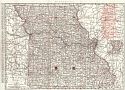
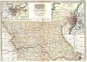
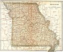
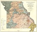
Viewing Options
Main Author:
Rand McNally & Co.
Title/Description:
Rand McNally & Co.'s Missouri
Publication Info:
Chicago: Rand McNally & Co., 1901
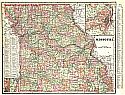
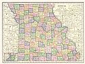
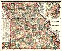
Viewing Options
Main Author:
Cram, George F.
Title/Description:
Missouri
Publication Info:
Chicago: The Fort Dearborn Publishing Co., 1901; from The National Standard Family and Business Atlas of the World
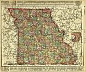
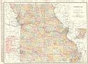
Viewing Options
Main Author:
Rand McNally and Company
Title/Description:
Missouri
Publication Info:
Chicago: Rand McNally and Co., 1901; from the Universal Atlas of the World
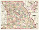
Viewing Options
Main Author:
Tunison, Henry Cuthbert
Title/Description:
Missouri
Publication Info:
New York: H.C. Tunison, 1901; from Tunison's Atlas, Encyclopædia, Gazetteer, and Portfolio of Our Universe, Globe, and Nation
Viewing Options
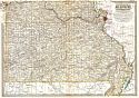
Viewing Options
Main Author:
The Century Company
Title/Description:
Missouri - Northern Part
Publication Info:
Buffalo: The Matthews-Northrup Co., 1902; from the 1902 edition of the Century Atlas
Original Source:
From the personal collection of Dr. Robert Burckhalter, Santa Fe, New Mexico
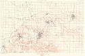
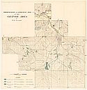
Viewing Options
Main Author:
U.S. Department of the Interior, U.S. Geological Survey
Title/Description:
Joplin District, Missour-Kansas
Publication Info:
Washington: U.S. Department of the Interior, U.S. Geological Survey, 1902
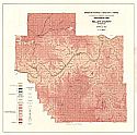
Viewing Options
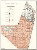
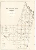
Main Author:
Ball, Sydney H. and A.F. Smith
Title/Description:
Geologic Map of Miller County, Missouri
Publication Info:
Missouri Bereau of Geology and Mines: from Report Vol 1, series 2
Viewing Options
Main Author:
Dodd, Mead and Company
Title/Description:
Missouri
Publication Info:
New York: Dodd, Mead and Company, 1903
Viewing Options
Main Author:
C.S. Hammond and Company
Title/Description:
Missouri
Publication Info:
New York: C.S. Hammond and Co., 1904
Viewing Options
Main Author:
Van Horn, F.B.
Title/Description:
Geologic Map of Moniteau County, Missouri
Publication Info:
Missouri Bureau of Geology and Mines: from Report Vol III, series 2
Viewing Options
Main Author:
Buchler, H.A.
Title/Description:
Map showing the Distribution of Quarries in the Granite District of Southeast Missouri
Publication Info:
Missouri Bureau of Geology and Mines 1904: from Report Vol II, series 2, Plate XII
Viewing Options
Main Author:
Buchler, H.A.
Title/Description:
A Geologic Map of Missouri Showing the Location of the Principal Stone Quarries
Publication Info:
Missouri Bureau of Geology and Mines 1904: from Report Vol 2, series 2, Plate 1
Viewing Options
Main Author:
Miller, J. Martin
Title/Description:
Missouri
Publication Info:
Unknown, 1904; from the Twentieth Century Atlas and Illustrated World
Viewing Options
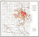
Main Author:
Buckley, E.R.
Title/Description:
Topographic and Geologic Map of the Granby Area
Publication Info:
Missouri:Bureau of Geology and Mines, 1905
Viewing Options
Main Author:
Rand McNally and Company
Title/Description:
Missouri
Publication Info:
Chicago: Rand McNally and Company, 1905; from Enlarged Business Atlas and Shippers Guide
Viewing Options
Main Author:
Missouri Bureau of Geology and Mines
Title/Description:
Economic Map of Moniteau County, Missouri
Publication Info:
Rolla: Missouri Bureau of Geology and Mines, 1905; Vol III, 2nd Series, Plate XIII

