Viewing Options
Main Author:
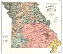
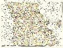
Missouri Geological Survey
Title/Description:
A Geological Map of Missouri: showing Distribution and Principal Development of the Clay Deposits
Publication Info:
Jefferson City: Geological Survey of Missouri, 1896; from report Vol XI Series Plate 2
Viewing Options
Main Author:
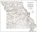
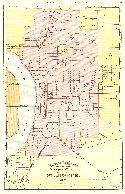
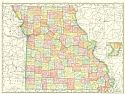
Missouri Geological Survey
Title/Description:
A sketch Map of Missouri showing the location of Clay Industries
Publication Info:
Jefferson City: Geological Survey of Missouri, 1896; from report Vol XI Series 1, Plate III
Viewing Options
Main Author:
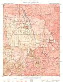
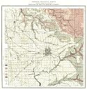
Missouri Geological Survey
Title/Description:
Geologic and Topographic Map- Mine La Motte Sheet
Publication Info:
Jefferson City: Geological Survey of Missouri, 1896
Viewing Options
Main Author:
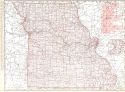
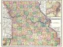
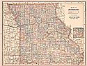
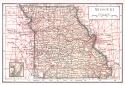
Rand McNally and Company
Title/Description:
Missouri
Publication Info:
Chicago: Rand McNally and Company, 1896; from Enlarged Business Atlas
Viewing Options
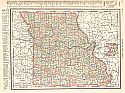
Main Author:
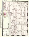
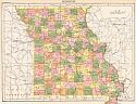
Rand McNally and Company
Title/Description:
Missouri
Publication Info:
Chicago: Rand McNally and Company,1896; from Indexed Atlas of the World
Viewing Options
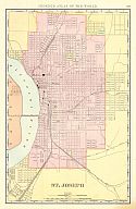
Main Author:
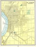
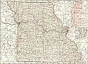
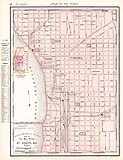
Rand McNally and Company
Title/Description:
St. Joseph
Publication Info:
Chicago: Rand McNally and Company,1896; from Indexed Atlas of the World

Viewing Options
Main Author:
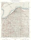
Secretary of War
Title/Description:
Missouri River Commission, Osage Division, First Reach Map of Missouri River from Stanley Island to Isbell Station
Publication Info:
Washington: Government Printing Office, 1896
Viewing Options
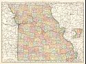
Main Author:
Cram, George F.
Title/Description:
Missouri
Publication Info:
Chicago: George F. Cram, 1898; from Cram's Universal Atlas, Geographical, Astronomical and Historical
Viewing Options
Main Author:
Cram, George F.
Title/Description:
St. Joseph, Missouri from Cram's Universal Atlas, Geographical, Astronomical and Historical
Publication Info:
Chicago: George F. Cram, 1898
Viewing Options
Main Author:
Rand McNally & Company
Title/Description:
Missouri
Publication Info:
Chicago: Rand McNally & Co., 1898; from Rand McNally & Co.'s Indexed Atlas of the World
Viewing Options
Main Author:
Rand McNally & Company
Title/Description:
Map of the Main Portion of St. Joseph, MO.
Publication Info:
Chicago: Rand McNally & Co., 1898; from Rand McNally & Co.'s Atlas of the World
Viewing Options
Main Author:
Missouri Geological Survey
Title/Description:
Geologic Map of Greene County
Publication Info:
Jefferson City: Geological Survey of Missouri, 1898; from report Vol 12, First Series
Viewing Options
Main Author:
Missouri Geological Survey
Title/Description:
Geologic and Topographic Map- Lexington Sheet
Publication Info:
Jefferson City: Geological Survey of Missouri, 1898; from report Vol XII Series 1
Viewing Options
Main Author:
Funk & Wagnalls Company
Title/Description:
Missouri
Publication Info:
New York: Funk & Wagnalls Company, 1898; from A Standard Atlas of the World
Viewing Options
Main Author:
Mast, Crowell and Kirkpatrick
Title/Description:
Map of Missouri
Publication Info:
Philadelphia: Mast, Crowell, & Kirkpatrick, 1898; from Peerless Atlas of the World
Viewing Options
Main Author:
Rand McNally and Company
Title/Description:
Missouri
Publication Info:
Chicago: Rand McNally and Company, c.1898
Viewing Options
Main Author:
Rand McNally and Company
Title/Description:
St. Joseph
Publication Info:
Chicago: Rand McNally and Company, c.1898
Viewing Options
Main Author:
Ogle, George A.
Title/Description:
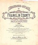
Standard Atlas of Franklin County, Missouri
Publication Info:
Chicago: George A. Ogle and Company, 1898
Viewing Options
Main Author:
Missouri River Commission
Title/Description:
Map of Missouri River at and near Napoleon in Lafayette County, Mo.
Publication Info:
St. Louis: Missouri River Commission, 1899
Viewing Options
Main Author:
Smith, Benjamin E.
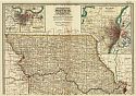
Title/Description:
Missouri- Northern Part
Publication Info:
New York: The Century Company, 1899; from The Century Atlas of the World
Viewing Options
Main Author:
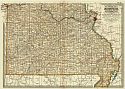
Smith, Benjamin E.
Title/Description:
Missouri- Southern Part
Publication Info:
New York: The Century Company, 1899; from The Century Atlas of the World
Viewing Options
Main Author:
The Bradstreet Company
Title/Description:
Missouri
Publication Info:
New York: The Bradstreet Company, 1899; from Bradstreet's Pocket Atlas of the United States
Viewing Options
Main Author:
Servoss, R.D.
Title/Description:
Missouri
Publication Info:
New York: The Snow-Church Surety Co., 1900
Viewing Options
Main Author:
Rand McNally & Company
Title/Description:
Missouri Railroads
Publication Info:
Chicago: Rand McNally & Company, 1900
Viewing Options
Main Author:
Rand McNally and Company
Title/Description:
The Main Portion of St. Joseph, MO
Publication Info:
Philadelphia: The Gebbie Publishing Company, 1900; from Spofford's Cabinet Cyclopedia Atlas of the World

