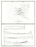
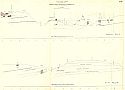
Viewing Options
Main Author:
Geological Survey of Missouri
Title/Description:
Topographical Sections of the Pilot Knob District
Publication Info:
Rolla: Geological Survey of Missouri, 1872; Plate Ia from Survey Report of 1872
Viewing Options
Main Author:
Geological Survey of Missouri
Title/Description:
Magnetic Geological Map of the Pilot Knob Iron District
Publication Info:
Rolla: Geological Survey of Missouri, 1872; Plate II from Survey Report of 1872
Viewing Options
Main Author:
Geological Survey of Missouri
Title/Description:
Topographical Magnetic Map of the Iron Mountain
Publication Info:
Rolla: Geological Survey of Missouri, 1872; Plate III from Survey Report of 1872
Viewing Options
Main Author:
Schmidt, Adolf
Title/Description:
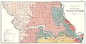
Preliminary Map Showing the Distribution of Iron Ores in Missouri
Publication Info:
Rolla: Geological Survey of Missouri, 1872; Plate IV from Survey Report of 1872
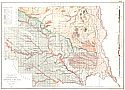
Viewing Options
Main Author:
Broadhead, G.C.
Title/Description:
Preliminary Geological Map of Northern Missouri
Publication Info:
Rolla: Geological Survey of Missouri, 1872; Plate V from Survey Report of 1872
Viewing Options
Main Author:
Broadhead, G.C.
Title/Description:
Grouped Sections of the Upper Coal Measures in N.W. Missouri
Publication Info:
Rolla:Geological Survey of Missouri, 1872; Plate VI from Survey Report of 1872
Viewing Options
Main Author:
Broadhead, G.C.
Title/Description:
Grouped Sections of the Lower and Middle Coal Measures in Henry, Johnson, Lafayette, Carroll, Ray, Livingston, Cass, and Jackson Counties
Publication Info:
Rolla: Geological Survey of Missouri, 1872; Plate VI a from Survey Report of 1872
Viewing Options
Main Author:
Broadhead, G.C.
Title/Description:
Preliminary Groupings of Some Geological Sections in N.E. Missouri
Publication Info:
Rolla: Geological Survey of Missouri, 1872; Plate VI b from Survey Report of 1872
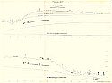
Viewing Options
Main Author:
Broadhead, G.C.
Title/Description:
Geological Profile from Kansas City to Jefferson City Along Line of Pacific Railroad
Publication Info:
Rolla: Geological Survey of Missouri, 1872; Plate VII a from Survey Report of 1872
Viewing Options
Main Author:
Broadhead, G.C.
Title/Description:
Geological Profile from Kansas City to Jefferson City Along Line of Pacific Railroad
Publication Info:
Rolla: Geological Survey of Missouri, 1872; Plate VII b from Survey Report of 1872
Viewing Options
Main Author:
Potter, W.B.
Title/Description:
Geological Map of Lincoln County
Publication Info:
Rolla: Geological Survey of Missouri, 1872; Plate VIII from Survey Report of 1872
Viewing Options
Main Author:
Potter, W.B.
Title/Description:
Map of Lincoln County Coal Region
Publication Info:
Rolla: Geological Survey of Missouri, 1872; Plate IX from Survey Report of 1872
Viewing Options
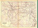
Main Author:
Asher and Adams
Title/Description:
Missouri
Publication Info:
New York: Asher and Adams, 1872; from New Statistical Atlas of the United States
Viewing Options
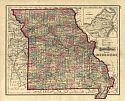
Main Author:
Gray, Ormando W.
Title/Description:
Missouri
Publication Info:
Philadelphia: Stedman, Brown and Lyon 1873; from Gray's Atlas of the United States with General Maps of the World
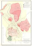
Viewing Options
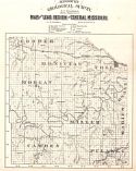
Title/Description:
Map of the Lead Region of Central Missouri
Publication Info:
Jefferson City: Missouri Geological Survey, 1874; from the Atlas to Accompany Reports of Missouri Geological Survey, 1874
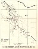
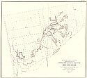
Viewing Options
Main Author:
Geological Survey of Missouri
Title/Description:
Sketch of the Joplin Lead District, T27N, R33W
Publication Info:
Jefferson City: Missouri Geological Survey, 1874 ; from the Atlas to Accompany Reports of Missouri Geological Survey, 1874
Viewing Options
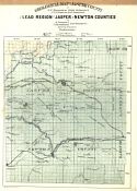
Main Author:
Schmidt, A. and A. Leonhard
Title/Description:
Geological Map of Jasper County with Lead Region of Jasper and Newton Counties
Publication Info:
Jefferson City: Missouri Geological Survey, 1874; from the Atlas to Accompany Reports of Missouri Geological Survey, 1874
Viewing Options
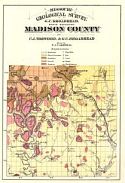
Main Author:
Norwood, C.J. and G.C. Broadhead
Title/Description:
Madison County
Publication Info:
Jefferson City: Missouri Geological Survey, 1874; from the Atlas to Accompany Reports of Missouri Geological Survey, 1874
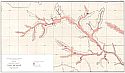
Viewing Options
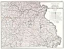
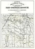
Main Author:
Broadhead, G.C. and Norwood, C.J.
Title/Description:
Part of Northern Missouri
Publication Info:
Jefferson City: Missouri Geological Survey, 1874; from the Atlas to Accompany Reports of Missouri Geological Survey, 1874
Viewing Options
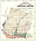
Main Author:
Broadhead, G.C. and Norwood, C.J.
Title/Description:
Howard County
Publication Info:
Jefferson City: Missouri Geological Survey, 1874; from the Atlas to Accompany Reports of Missouri Geological Survey, 1874
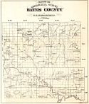
Viewing Options
Main Author:
Broadhead, G.C.
Title/Description:
Bates County
Publication Info:
Jefferson City: Missouri Geological Survey, 1874; from the Atlas to Accompany Reports of Missouri Geological Survey, 1874
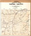
Viewing Options
Main Author:
Broadhead, G.C.
Title/Description:
Vernon County
Publication Info:
Jefferson City: Missouri Geological Survey, 1874; from the Atlas to Accompany Reports of Missouri Geological Survey, 1874
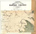
Viewing Options
Main Author:
Broadhead, G.C.
Title/Description:
Barton County
Publication Info:
Jefferson City: Missouri Geological Survey, 1874; from the Atlas to Accompany Reports of Missouri Geological Survey, 1874
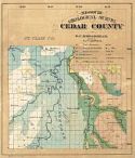
Viewing Options
Main Author:
Broadhead, G.C.
Title/Description:
Cedar County
Publication Info:
Jefferson City: Missouri Geological Survey, 1874; from the Atlas to Accompany Reports of Missouri Geological Survey, 1874

