Historical Maps of Other Southeastern States

Selected Missouri Out-of-Print Quadrangles

Before 1880
1880-1900
After 1900
Next Page

  Main Author:   Meigs, Josiah
  Title/Description:   Sketch of the Lead Mine District in Washington County Missouri Territory
  Publication Info:   Washington, D.C.: General Land Office, 1816
  Date:   1816
  Scale:   1:125,000
  Original Source:   Courtesy of Murray Hudson, Halls, Tennessee
Viewing options:


  Main Author:   Finley, Anthony
  Title/Description:   Missouri
  Publication Info:   Philadelphia: Anthony Finley, 1824
  Date:   1824
  Scale:   1:2,408,000
  Original Source:   Rucker Agee Map Collection
Viewing options:


  Main Author:    
  Title/Description:   Map of the State of Missouri
  Publication Info:   London: Hinton, Simpkin and Marshall, 1832
  Date:   1832
  Scale:   1:2,393,000
  Original Source:  

Rucker Agee Map Collection

Viewing options:


  Main Author:   Bradford, Thomas
  Title/Description:   Missouri
  Publication Info:   Boston: Thomas Bradford, [1839]
  Date:   1839
  Scale:   1:1,837,000
  Original Source:   Rucker Agee Map Collection
Viewing options:


  Main Author:   Milburn, William S., Surveyor General
  Title/Description:   Diagram of the State of Missouri
  Publication Info:   Washington, D.C.: W.J. Stone, 1839
  Date:   1839
  Scale:   1:1,140,000
  Original Source:   Courtesy of Murray Hudson, Halls, Tennessee
Viewing options:


  Main Author:   Stone, W.J.
  Title/Description:   No. 5 Missouri
  Publication Info:   Washington, D.C.: Blair & Rives, 1841
  Date:   1841
  Scale:   1:2,534,000
  Original Source:   Courtesy of Murray Hudson, Halls, Tennessee
Viewing options:


  Main Author:   Meyer, Joseph
  Title/Description:   Neueste karte von Missouri
  Publication Info:   Hildburg; 1845
  Date:   1845
  Scale:   1:1,964,000
  Original Source:   Rucker Agee Map Collection
Viewing options:


  Main Author:   Conway, F.R.
  Title/Description:   Diagram of the State of Missouri
  Publication Info:   Saint Louis: Surveyor of Public Lands in the States of Illinois and Missouri
  Date:   1845
  Scale:   1:1,267,000
  Original Source:   Rucker Agee Map Collection
Viewing options:


  Main Author:   General Land Office
  Title/Description:   H Diagram of the State of Missouri
  Publication Info:   Washington, D.C.: General Land Office, 1845
  Date:   1845
  Scale:   1:1,267,000
  Original Source:   Courtesy of Murray Hudson, Halls, Tennessee
Viewing options:


  Main Author:   Mitchell, S. Augustus
  Title/Description:   A New Map of Missouri with its Roads and Distances
  Publication Info:   Philadelphia: S. Augustus Mitchell, 1846
  Date:   1846
  Scale:   1:1,901,000
  Original Source:   Rucker Agee Map Collection
Viewing options:


  Main Author:   Office of the Surveyor General
  Title/Description:   Diagram of the State of Missouri
  Publication Info:   Washington, D.C.: General Land Office, 1849
  Date:   1849
  Scale:   1:1,267,200
  Original Source:   Courtesy of Murray Hudson, Halls, Tennessee
Viewing options:


  Main Author:   Clark, M. Lewis
  Title/Description:   Diagram of the State of Missouri
  Publication Info:   Saint Louis: Office of the Surveyor General for the States of Illinois and Missouri, 1849
  Date:   1849
  Scale:   1:1,267,000
  Original Source:   Rucker Agee Map Collection
Viewing options:


  Main Author:   Price, R.B.
  Title/Description:   Geological Map of Jefferson County
  Publication Info:   St. Louis: B.F. Shumard, c.1850; from a state geologic survey
  Date:   1850
  Scale:   1:190,000
  Original Source:   Courtesy of Murray Hudson, Halls, Tennessee
Viewing options:


  Main Author:   Thomas, Cowperthwait & Co.
  Title/Description:   A New Map of the State of Missouri
  Publication Info:   Philadelphia: Thomas, Cowperthwait & Co., 1854
  Date:   1854
  Scale:   1:1,837,000
  Original Source:   Courtesy of Murray Hudson, Halls, Tennessee
Viewing options:


  Main Author:   Desilver, Charles
  Title/Description:   State of Missouri
  Publication Info:   Philadelphia: Charles Desilver, c. 1856
  Date:   1856
  Scale:   1:1,775,000
  Original Source:   Courtesy of Adams Antiques, Northport, Alabama
Viewing options:


  Main Author:   Colton, Joseph H.
  Title/Description:   Missouri
  Publication Info:   New York: J.H. Colton, 1856
  Date:   1856
  Scale:   1:1,711,000
  Original Source:   Courtesy of Murray Hudson, Halls, Tennessee
Viewing options:


  Main Author:   Johnson and Ward
  Title/Description:   Johnson's Missouri and Kansas
  Publication Info:   New York: Johnson and Ward, 1864
  Date:   1864
  Scale:   1:1,521,000
  Original Source:   Courtesy of Murray Hudson, Halls, Tennessee
Viewing options:


  Main Author:   Johnson, Alvin J.
  Title/Description:   Johnson's Missouri and Kansas
  Publication Info:   New York: A.J. Johnson, 1865
  Date:   1865
  Scale:   1:1,331,0000
  Original Source:   Courtesy of Murray Hudson, Halls, Tennessee
Viewing options:


  Main Author:   General Land Office
  Title/Description:   Diagram of the State of Missouri
  Publication Info:   Washington, D.C.: General Land Office, 1865
  Date:   1865
  Scale:   1:1,267,000
  Original Source:   Courtesy of Murray Hudson, Halls, Tennessee
Viewing options:


  Main Author:   Mitchell, S. Augustus, Jr.
  Title/Description:   St. Louis
  Publication Info:   Philadelphia: S. Augustus Mitchell, Jr., c.1867
  Date:   1867
  Scale:   not indicated
  Original Source:   Courtesy of Murray Hudson, Halls, Tennessee
Viewing options:


  Main Author:   Geological Survey of Missouri
  Title/Description:   Topographical Sections of the Pilot Knob District
  Publication Info:   Geological Survey of Missouri, 1872; Plate Ia from Survey Report of 1872
  Date:   1872
  Scale:    
  Original Source:   University of Alabama Map Library
Viewing options:


  Main Author:   Geological Survey of Missouri
  Title/Description:   Magnetic Geological Map of the Pilot Knob Iron District
  Publication Info:   Geological Survey of Missouri, 1872; Plate II from Survey Report of 1872
  Date:   1872
  Scale:   1:14,000
  Original Source:   University of Alabama Map Library
Viewing options:


  Main Author:   Geological Survey of Missouri
  Title/Description:   Topographic Magnetic Map of the Iron Mountain
  Publication Info:   Geological Survey of Missouri, 1872; Plate III from Survey Report of 1872
  Date:   1872
  Scale:   1:1,200
  Original Source:   University of Alabama Map Library
Viewing options:


  Main Author:   Schmidt, Adolf
  Title/Description:   Preliminary Map Showing the Distribution of Iron Ores in Missouri
  Publication Info:   Geological Survey of Missouri, 1872; Plate IV from Survey Report of 1872
  Date:   1872
  Scale:   1:633,600
  Original Source:   University of Alabama Map Library
Viewing options:


  Main Author:   Broadhead, G.C.
  Title/Description:   Preliminary Geological Map of North Missouri
  Publication Info:   Geological Survey of Missouri, 1872; Plate V from Survey Report of 1872
  Date:   1872
  Scale:   1:633,600
  Original Source:   University of Alabama Map Library
Viewing options:


  Main Author:   Broadhead, G.C.
  Title/Description:   Grouped Sections of the Upper Coal Measures in N.W. Missouri
  Publication Info:   Geological Survey of Missouri, 1872; Plate VI from Survey Report of 1872
  Date:   1872
  Scale:    
  Original Source:   University of Alabama Map Library
Viewing options:


  Main Author:   Broadhead, G.C.
  Title/Description:   
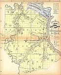
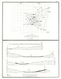
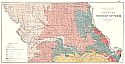
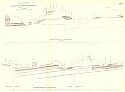
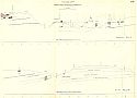
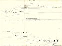
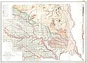
Grouped Sections of the Lower and Middle Coal Measures in Henry, Johnson, Lafayette, Carroll, Ray, Livingston, Cass, and Jackson Counties
  Publication Info:   Geological Survey of Missouri, 1872; Plate VIa from Survey Report of 1872
  Date:   1872
  Scale:    
  Original Source:   University of Alabama Map Library
Viewing options:


  Main Author:   Broadhead, G.C.
  Title/Description:   Preliminary Groupings of Some Geological Sections in N.E. Missouri
  Publication Info:   Geological Survey of Missouri, 1872; Plate VI from Survey Report of 1872
  Date:   1872
  Scale:    
  Original Source:   University of Alabama Map Library
Viewing options:


  Main Author:   Broadhead, G.C.
  Title/Description:   Geological Profile from Kansas City to Jefferson City Along Line of Pacific Railroad
  Publication Info:   Geological Survey of Missouri, 1872; Plate VII from Survey Report of 1872
  Date:   1872
  Scale:    
  Original Source:   University of Alabama Map Library
Viewing options:


  Main Author:   Broadhead, G.C.
  Title/Description:   Geological Profile from Kansas City to Jefferson City Along Line of Pacific Railroad
  Publication Info:   Geological Survey of Missouri, 1872; Plate VIIa from Survey Report of 1872
  Date:   1872
  Scale:    
  Original Source:   University of Alabama Map Library
Viewing options:


  Main Author:   Broadhead, G.C.
  Title/Description:   Geological Profile from Kansas City to Jefferson City Along Line of Pacific Railroad
  Publication Info:   Geological Survey of Missouri, 1872; Plate VIIb from Survey Report of 1872
  Date:   1872
  Scale:    
  Original Source:   University of Alabama Map Library
Viewing options:


  Main Author:   Potter, W.B.
  Title/Description:   Geological Map of Lincoln County
  Publication Info:   Geological Survey of Missouri, 1872; Plate VIII from Survey Report of 1872
  Date:   1872
  Scale:   1:63,360
  Original Source:   University of Alabama Map Library
Viewing options:


  Main Author:   Potter, W.B.
  Title/Description:   Map of Lincoln County Coal Region
  Publication Info:   Geological Survey of Missouri, 1872; Plate IX from Survey Report of 1872
  Date:   1872
  Scale:   1:14,000
  Original Source:   University of Alabama Map Library
Viewing options:


  Main Author:   Schmidt, A.
  Title/Description:   Map of the Lead Region of Central Missouri
  Publication Info:   Jefferson City: Missouri Geological Survey, 1874; from the Atlas to Accompany Reports of Missouri Geological Survey, 1874
  Date:   1874
  Scale:   1:380,000
  Original Source:   Geological Survey of Alabama
Viewing options:


  Main Author:    
  Title/Description:   Sketch of the Joplin Lead District, T27N, R33W
  Publication Info:   Jefferson City: Missouri Geological Survey, 1874; from the Atlas to Accompany Reports of Missouri Geological Survey, 1874
  Date:   1874
  Scale:   1:250,000
  Original Source:   Geological Survey of Alabama
Viewing options:


  Main Author:   Schmidt, A. & A. Leonhard
  Title/Description:   Geologic Map of Jasper County with Lead Region of Jasper and Newton Counties
  Publication Info:   Jefferson City: Missouri Geological Survey, 1874; from the Atlas to Accompany Reports of Missouri Geological Survey, 1874
  Date:   1874
  Scale:   1:250,000
  Original Source:   Geological Survey of Alabama
Viewing options:


  Main Author:   Norwood, C.J. & G.C. Broadhead
  Title/Description:   Madison County
  Publication Info:   Jefferson City: Missouri Geological Survey, 1874; from the Atlas to Accompany Reports of Missouri Geological Survey, 1874
  Date:   1874
  Scale:   1:190,000
  Original Source:   Geological Survey of Alabama
Viewing options:


  Main Author:   Broadhead, G.C. & C.J. Norwood
  Title/Description:   Part of Northern Missouri
  Publication Info:   Jefferson City: Missouri Geological Survey, 1874; from the Atlas to Accompany Reports of Missouri Geological Survey, 1874
  Date:   1874
  Scale:   1:250,000
  Original Source:   Geological Survey of Alabama
Viewing options:


  Main Author:   Broadhead, G.C. & C.J. Norwood
  Title/Description:   Howard County
  Publication Info:   Jefferson City: Missouri Geological Survey, 1874; from the Atlas to Accompany Reports of Missouri Geological Survey, 1874
  Date:   1874
  Scale:   1:190,000
  Original Source:   Geological Survey of Alabama
Viewing options:


  Main Author:   Broadhead, G.C.
  Title/Description:   Bates County
  Publication Info:   Jefferson City: Missouri Geological Survey, 1874; from the Atlas to Accompany Reports of Missouri Geological Survey, 1874
  Date:   1874
  Scale:   1:190,000
  Original Source:   Geological Survey of Alabama
Viewing options:


  Main Author:   Broadhead, G.C.
  Title/Description:   Vernon County
  Publication Info:   Jefferson City: Missouri Geological Survey, 1874; from the Atlas to Accompany Reports of Missouri Geological Survey, 1874
  Date:   1874
  Scale:   1:190,000
  Original Source:   Geological Survey of Alabama
Viewing options:


  Main Author:   Broadhead, G.C.
  Title/Description:   Barton County
  Publication Info:   Jefferson City: Missouri Geological Survey, 1874; from the Atlas to Accompany Reports of Missouri Geological Survey, 1874
  Date:   1874
  Scale:   1:190,000
  Original Source:   Geological Survey of Alabama
Viewing options:


  Main Author:   Broadhead, G.C.
  Title/Description:   Cedar County
  Publication Info:   Jefferson City: Missouri Geological Survey, 1874; from the Atlas to Accompany Reports of Missouri Geological Survey, 1874
  Date:   1874
  Scale:   1:190,000
  Original Source:   Geological Survey of Alabama
Viewing options:


  Main Author:   Mitchell, S. Augustus
  Title/Description:   St. Louis
  Publication Info:   Philadelphia: S. Augustus Mitchell, c.1874
  Date:   1874
  Scale:   not indicated
  Original Source:   Courtesy of Murray Hudson, Halls, Tennessee
Viewing options:


  Main Author:   Roeser, C.
  Title/Description:   State of Missouri
  Publication Info:   Washington, D.C.: Department of the Interior, General Land Office, 1878
  Date:   1878
  Scale:   1:887,000
  Original Source:   Geological Survey of Alabama
Viewing options:


  Main Author:   Cram, George F.
  Title/Description:   Cram's Railroad & Township Map of Missouri
  Publication Info:   Chicago: George F. Cram, 1879
  Date:   1879
  Scale:   1:1,204,000
  Original Source:   Courtesy of Murray Hudson, Halls, Tennessee
Viewing options:
 

Next Page