Historical Maps of Other Southeastern States

After 1900


Before 1885
1885 - 1900
After 1900


  Main Author:   Crowell and Kirkpatrick
  Title/Description:   Minnesota
  Publication Info:   Springfield, OH: Crowell and Kirkpatrick, 1901
  Date:   1901
  Scale:   1:2,534,000
  Original Source:   Courtesy of Murray Hudson, Halls, Tennessee
Viewing options:


  Main Author:   U.S. Geological Survey
  Title/Description:   Geological Map of a Part of the Mesabi District
  Publication Info:   Washington: Department of the Interior, U.S. Geological Survey, 1901; 21st Annual Report, Part III Plate II
  Date:   1901
  Scale:   1:63,360
  Original Source:   Courtesy of Murray Hudson, Halls, Tennessee
Viewing options:


  Main Author:   Cram, George F.
  Title/Description:   Minnesota
  Publication Info:   Chicago: The Fort Dearborn Publishing Company, 1901; from The National Standard Family and Business Atlas of the World
  Date:   1901
  Scale:   1:2,344,320
  Original Source:   Courtesy of Murray Hudson, Halls, Tennessee
Viewing options:


  Main Author:   Rand McNally and Company
  Title/Description:   Minnesota
  Publication Info:   Chicago: Rand McNally and Company, 1901; from The Enlarged Business Atlas and Shippers Guide
  Date:   1901
  Scale:   1:1,013,760
  Original Source:   Courtesy of Murray Hudson, Halls, Tennessee
Viewing options:


  Main Author:   Rand McNally and Company
  Title/Description:   Minnesota
  Publication Info:   Chicago: Rand McNally and Company, 1901; from The Universal Atlas of the World
  Date:   1901
  Scale:   1:2,154,240
  Original Source:   Courtesy of Murray Hudson, Halls, Tennessee
Viewing options:


  Main Author:   Rand McNally and Company
  Title/Description:   Minnesota
  Publication Info:   Chicago: Rand McNally and Company, [1902]
  Date:   1902
  Scale:   1:2,218,000
  Original Source:   University of Alabama Map Library
Viewing options:


  Main Author:   The Century Company
  Title/Description:   Minnesota
  Publication Info:   Buffalo: The Matthew-Northrup Co., 1902; from The Century Atlas of the World
  Date:   1902
  Scale:   1:1,774,080
  Original Source:   Courtesy of Murray Hudson, Halls, Tennessee
Viewing options:
 

  Main Author:   Cram, George F.
  Title/Description:   Map of Minnesota
  Publication Info:   Chicago: George F. Cram, 1903; from The Modern Atlas
  Date:   1903
  Scale:   1:1,393,920
  Original Source:   Courtesy of Murray Hudson, Halls, Tennessee
Viewing options:


  Main Author:   Miller, J. Martin
  Title/Description:   Minnesota
  Publication Info:   unknown, 1904; from The Twentieth Century Atlas and Illustrated World
  Date:   1904
  Scale:   1:2,059,200
  Original Source:   Courtesy of Murray Hudson, Halls, Tennessee
Viewing options:


  Main Author:   Rand McNally and Company
  Title/Description:   Minnesota
  Publication Info:   Chicago: Rand McNally and Company, 1905; from The Unrivaled Atlas of the World
  Date:   1905
  Scale:   1:2,154,240
  Original Source:   Courtesy of Murray Hudson, Halls, Tennessee
Viewing options:


  Main Author:   Rand McNally and Company
  Title/Description:   Minnesota
  Publication Info:   Chicago: Rand McNally and Company, 1905; from The Enlarged Business Atlas and Shippers Guide
  Date:   1905
  Scale:   1:1,013,760
  Original Source:   Courtesy of Murray Hudson, Halls, Tennessee
Viewing options:


  Main Author:   Rand McNally and Company
  Title/Description:   Minnesota
  Publication Info:   Chicago: Rand McNally and Company, 1906; from The Business Atlas and Shippers Guide
  Date:   1906
  Scale:   1:1,013,760
  Original Source:   Courtesy of Murray Hudson, Halls, Tennessee
Viewing options:


  Main Author:   C.S. Hammond and Company
  Title/Description:   Minnesota
  Publication Info:   New York: C.S. Hammond and Company, 1906; from The Pictorial Atlas of the World
  Date:   1906
  Scale:   1:2,534,400
  Original Source:   Courtesy of Murray Hudson, Halls, Tennessee
Viewing options:


  Main Author:   Cram, George F.
  Title/Description:   Map of Minnesota
  Publication Info:   Chicago: George F. Cram, 1907; from The Standard American Atlas
  Date:   1907
  Scale:   1:1,457,280
  Original Source:   University of Alabama Map Library
Viewing options:


  Main Author:   P.F. Collier and Son
  Title/Description:   Minnesota
  Publication Info:   New York: P.F. Collier and Son, 1907; from The New Encyclopedic Atlas and Gazeteer of the World
  Date:   1907
  Scale:   1:2,534,400
  Original Source:   Courtesy of Murray Hudson, Halls, Tennessee
Viewing options:


  Main Author:   The Crowell Publishing Company
  Title/Description:   Minnesota
  Publication Info:   New York: The Crowell Publishing Company, 1908; from The Twentieth Century Peerless Atlas
  Date:   1908
  Scale:   1:2,090,880
  Original Source:   Courtesy of Murray Hudson, Halls, Tennessee
Viewing options:


  Main Author:   Patten, William and J.E. Homas
  Title/Description:   Minnesota
  Publication Info:   New York: P.F. Collier and Son, 1909; from The New Encyclopedic Atlas and Gazetteer of the World
  Date:   1909
  Scale:   1:2,534,400
  Original Source:   University of Alabama Map Library
Viewing options:


  Main Author:   Cram, George F.
  Title/Description:   Minnesota
  Publication Info:   Chicago: George F. Cram, 1909; from The Art of Our Country
  Date:   1909
  Scale:   1:1,900,800
  Original Source:   Courtesy of Murray Hudson, Halls, Tennessee
Viewing options:


  Main Author:   Rand McNally and Company
  Title/Description:   Minnesota
  Publication Info:   Chicago: Rand McNally and Company, 1910; from The Enlarged Business Atlas and Shippers Guide
  Date:   1910
  Scale:   1:1,013,760
  Original Source:   Courtesy of Murray Hudson, Halls, Tennessee
Viewing options:


  Main Author:   U.S. Geological Survey
  Title/Description:   Geologic Map of the Vermilioin Iron-Bearing District, Minnesota
  Publication Info:   Washington: Department of the Interior, U.S. Geological Survey, 1910; Monograph 52 Plate 6
  Date:   1910
  Scale:   1:125,000
  Original Source:   Geological Survey of Alabama
Viewing options:


  Main Author:   U.S. Geological Survey
  Title/Description:   Map of Southern Minnesota Showing Underground Water Conditions
  Publication Info:   Washington: Department of the Interior, U.S. Geological Survey, 1910; from Water Supply Paper No. 256 Plate IV
  Date:   1910
  Scale:   1:750,000
  Original Source:   Geological Survey of Alabama
Viewing options:


  Main Author:   U.S. Geological Survey
  Title/Description:   Map of Southern Minnesota Showing Occurance of Granite Rock and Sioux Quartzite
  Publication Info:   Washington: Department of the Interior, U.S. Geological Survey, 1910; from Water Supply Paper No. 256 Plate III
  Date:   1910
  Scale:   1:750,000
  Original Source:   Geological Survey of Alabama
Viewing options:


  Main Author:   U.S. Geological Survey
  Title/Description:   Topographic Map of Southern Minnesota
  Publication Info:   Washington: Department of the Interior, U.S. Geological Survey, 1910; from Water Supply Paper No. 256 Plate I
  Date:   1910
  Scale:   1:750,000
  Original Source:   Geological Survey of Alabama
Viewing options:


  Main Author:   U.S. Geological Survey
  Title/Description:   Map of Southern Minnesota Showing Thickness and Character of Surface Deposits
  Publication Info:   Washington: Department of the Interior, U.S. Geological Survey, 1910; from Water Supply Paper No. 256 Plate II
  Date:   1910
  Scale:   1:750,000
  Original Source:   Geological Survey of Alabama
Viewing options:


  Main Author:   Rand McNally and Company
  Title/Description:   Minnesota
  Publication Info:   Chicago: Rand McNally and Company, c.1911; from The Indexed Atlas of the World
  Date:   1911
  Scale:   1:1,014,000
  Original Source:   Courtesy of Murray Hudson, Halls, Tennessee
Viewing options:


  Main Author:   Hammond, C.S.
  Title/Description:   Minnesota
  Publication Info:   New York: C.S. Hammond and Company, 1911; from The Modern Atlas of the World
  Date:   1911
  Scale:   1:2,534,000
  Original Source:   Courtesy of Murray Hudson, Halls, Tennessee
Viewing options:


  Main Author:    
  Title/Description:   Minnesota
  Publication Info:   Chicago: Geographical Publishing Company, 1911
  Date:   1911
  Scale:   1:2,217,600
  Original Source:   Courtesy of Murray Hudson, Halls, Tennessee
Viewing options:


  Main Author:   Rand McNally and Company
  Title/Description:   Minnesota
  Publication Info:   Chicago: Rand McNally and Company, 1912; from The Library Atlas of the World
  Date:   1912
  Scale:   1:1,013,760
  Original Source:   Courtesy of Murray Hudson, Halls, Tennessee
Viewing options:


  Main Author:   Rand McNally and Company
  Title/Description:   Minnesota
  Publication Info:   Chicago: Rand McNally and Company; from The Rand McNally Imperial Atlas of the World
  Date:   1912
  Scale:   1:2,154,240
  Original Source:   Courtesy of Murray Hudson, Halls, Tennessee
Viewing options:


  Main Author:   Rand McNally and Company
  Title/Description:   Rand McNally and Company's New Map of Minnesota
  Publication Info:   Chicago: Rand McNally and Company, 1913
  Date:   1913
  Scale:   1:2,154,000
  Original Source:   Courtesy of Murray Hudson, Halls, Tennessee
Viewing options:


  Main Author:   The Century Company
  Title/Description:   Minnesota
  Publication Info:   New York: The Century Company, 1913; from The Century Atlas of the World
  Date:   1913
  Scale:   1:1,774,080
  Original Source:   University of Alabama Map Library
Viewing options:


  Main Author:   Rand McNally and Company
  Title/Description:   Minnesota
  Publication Info:   Chicago: Rand McNally and Company, 1914; from The Commercial Atlas of America
  Date:   1914
  Scale:   1:1,013,760
  Original Source:   Courtesy of Murray Hudson, Halls, Tennessee
Viewing options:


  Main Author:   Rand McNally and Company
  Title/Description:   St. Paul, Minneapolis and Environs; Business Portion of Minneapolis; Business Portion of St. Paul
  Publication Info:   Chicago: Rand McNally and Company, 1914; from The Commercial Atlas of America
  Date:   1914
  Scale:   various
  Original Source:   Courtesy of Murray Hudson, Halls, Tennessee
Viewing options:


  Main Author:   Reynolds, Francis J.
  Title/Description:   Minnesota
  Publication Info:   New York: P.F. Collier and Son, 1914; from the New Encyclopedic Atlas and Gazeteer of the World
  Date:   1914
  Scale:   1:2,534,400
  Original Source:   Courtesy of Murray Hudson, Halls, Tennessee
Viewing options:


  Main Author:   U.S. Geological Survey
  Title/Description:   State of Minnesota
  Publication Info:   Washington: Department of the Interior, U.S. Geological Survey, 1917; compiled 1910-1911, reprinted 1944
  Date:   1917
  Scale:   1:1,000,000
  Original Source:   W. S. Hoole Special Collections Library
Viewing options:


  Main Author:   U.S. Geological Survey
  Title/Description:   Map of the St. Cloud Region, Minnesota Showing Rock Outcrops
  Publication Info:   Washington: Department of the Interior, U.S. Geological Survey, 1917; from Bulletin 663 Plate I
  Date:   1917
  Scale:   1:62,500
  Original Source:   Geological Survey of Alabama
Viewing options:


  Main Author:   Reynolds, Francis J.
  Title/Description:   Minnesota
  Publication Info:   New York: P.F. Collier and Son Company, 1920; from The New World Atlas and Gazetteer
  Date:   1920
  Scale:   1:3,168,000
  Original Source:   Courtesy of Murray Hudson, Halls, Tennessee
Viewing options:


  Main Author:   Cram, George F.
  Title/Description:   Minnesota
  Publication Info:   Chicago: George F. Cram, 1920; from Descriptive Review the Development of the State of Pennsylvania
  Date:   1920
  Scale:   1:1,900,800
  Original Source:   Courtesy of Murray Hudson, Halls, Tennessee
Viewing options:


  Main Author:   Rand McNally and Company
  Title/Description:   Minnesota
  Publication Info:   Chicago: Rand McNally and Company; from The Commercial Atlas of America
  Date:   1921
  Scale:   1:1,013,760
  Original Source:   University of Alabama Map Library
Viewing options:


  Main Author:   Rand McNally and Company
  Title/Description:   Minnesota - Black and White Mileage Map
  Publication Info:   Chicago: Rand McNally and Company; from The Commercial Atlas of America
  Date:   1921
  Scale:   1,439,999
  Original Source:   University of Alabama Map Library
Viewing options:


  Main Author:   The Geographical Publishing Company
  Title/Description:   Minnesota
  Publication Info:   Chicago: The Geographical Publishing Company, 1922; from The New International Atlas of the World
  Date:   1922
  Scale:   1:2,217,600
  Original Source:   Courtesy of Murray Hudson, Halls, Tennessee
Viewing options:


  Main Author:   C.S. Hammond and Company
  Title/Description:   Minnesota
  Publication Info:   New York: C.S. Hammond and Company, 1922; from the New World Loose Leaf Atlas
  Date:   1922
  Scale:   1:1,774,080
  Original Source:   Courtesy of Murray Hudson, Halls, Tennessee
Viewing options:


  Main Author:   U.S. Geological Survey
  Title/Description:   Map Showing Distribution of Peat in Northern Minnesota
  Publication Info:   Washington: Department of the Interior, U.S. Geological Survey, 1922; Bulletin 728 Plate 86
  Date:   1922
  Scale:   1:1,000,000
  Original Source:   Geological Survey of Alabama
Viewing options:


  Main Author:   Laverett, Frank and Frederick W. Sardeson
  Title/Description:   Map of the Southern Part of Minnesota Showing Surficial Deposits
  Publication Info:   Washington: Department of the Interior, U.S. Geological Survey, 1932; Professional Paper 161, Plate 2
  Date:   1932
  Scale:   1:500,000
  Original Source:   Geological Survey of Alabama
Viewing options:


  Main Author:   Laverett, Frank and Frederick W. Sardeson
  Title/Description:   Map of the northern part of Minnesota showing surficial deposits
  Publication Info:   Washington: Department of the Interior, U.S. Geological Survey, 1932; Professional Paper 161, Plate 1
  Date:   1932
  Scale:   1:500,000
  Original Source:   Geological Survey of Alabama
Viewing options:


Main Author:   Minnesota Geological Survey
Title/Description:   Geological Map of Minnesota
Publication Info:   Minneapolis: Minnesota Geological Survey, 1932
Date:   1932
Scale:   1:500,000
Original Source:   Geological Survey of Alabama
 
Northern Half
Viewing options:
 
Southern Half
Viewing options:


  Main Author:   Minnesota Geological Survey
  Title/Description:   Structural Contour Map of the Minneapolis - St. Paul Artesian Basin
  Publication Info:   Minneapolis: Minnesota Geological Survey, 1936; Bulletin 27, Plate 5
  Date:   1936
  Scale:   1:250,000
  Original Source:   University of Alabama Map Library
Viewing options:


  Main Author:   Minnesota Geological Survey
  Title/Description:   Map of Minneapolis Showing the Rock Surface Topography
  Publication Info:   Minneapolis: Minnesota Geological Survey, 1936; Bulletin 27, Plate 6
  Date:   1936
  Scale:   1:41,800
  Original Source:   University of Alabama Map Library
Viewing options:


  Main Author:   Minnesota Geological Survey
  Title/Description:   Map of St. Paul Showing the Rock Surface Topography
  Publication Info:   Minneapolis: Minnesota Geological Survey, 1936; Bulletin 27, Plate 7
  Date:   1936
  Scale:   1:41,000
  Original Source:   University of Alabama Map Library
Viewing options:


  Main Author:   Mid-West Map Company
  Title/Description:   Sears Official Road Map, Minnesota
  Publication Info:   Aurora, MO: Mid-West Map Company, c.1937
  Date:   1937
  Scale:   1:2,091,000
  Original Source:   Courtesy of Murray Hudson, Halls, Tennessee
Viewing options:


  Main Author:   Minnesota Geological Survey
  Title/Description:   Pliestone Geology of the Randall Region, Minnesota
  Publication Info:   Minneapolis: Minnesota Geological Survey, 1961; Bulletin 40, Plate 1
  Date:   1961
  Scale:   1:62,500
  Original Source:   Courtesy of Murray Hudson, Halls, Tennessee
Viewing options:


  Main Author:   Minnesota Geological Survey
  Title/Description:   
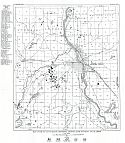
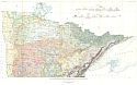
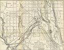
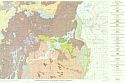
Geologic map of Duluth and vicinity, St. Loius County, Minnesota
  Publication Info:   Minneapolis: Minnesota Geological Survey, 1964; Bulletin 44, Plate 1
  Date:   1964
  Scale:   1:24,000
  Original Source:   Courtesy of Murray Hudson, Halls, Tennessee
Viewing options: