Selected Minnesota Out-of-Print Quadrangles
Next Page
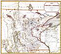
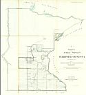
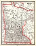
Main Author:
Morawsk, P.S.
Title/Description:
Map of the Territory of Minnesota exhibiting the route of the expedition to the Red River of the North, in the Summer of 1849 by Capt. John Pope
Publication Info:
[Washington: 1850]
Date:
1849
Scale:
Original Source:
Rucker Agee Map Collection
Viewing options:
JPEG
or
Plugin
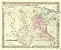
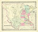
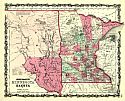
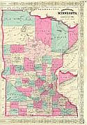
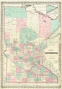
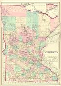
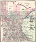
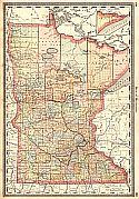
Main Author:
Colton, Joseph Hutchins
Title/Description:
Minnesota
Publication Info:
New York: J.H. Colton & Co., 1855
Date:
1855
Scale:
1:2,534,000
Original Source:
Courtesy of
Murray Hudson
, Halls, Tennessee
Viewing options:
JPEG
or
Plugin
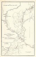
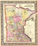
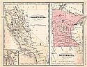
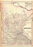
Main Author:
Simpson, James Hervey
Title/Description:
Map of the General Government Roads in Minnesota and Wisconsin
Publication Info:
Washington: A.O.P. Nicholson, 1855; Accompanying Annual Report to the 84th Congress. September 20th 1855.
Date:
1855
Scale:
1:1,521,000
Original Source:
Courtesy of
Murray Hudson
, Halls, Tennessee
Viewing options:
JPEG
or
Plugin
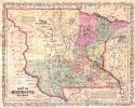
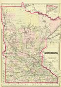
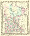
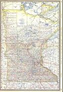
Main Author:
Young, J.H.
Title/Description:
Map of Minnesota Territory
Publication Info:
Philadelphia: Charles Desilver, c. 1856
Date:
1856
Scale:
1:2,400,000
Original Source:
Courtesy of Adams Antiques, Northport, Alabama
Viewing options:
JPEG
or
Plugin
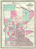
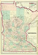
Main Author:
Colton, Joseph Hutchins
Title/Description:
Minnesota
Publication Info:
New York: J.H. Colton & Co.,1856
Date:
1856
Scale:
1:2,534,000
Original Source:
Courtesy of
Murray Hudson
, Halls, Tennessee
Viewing options:
JPEG
or
Plugin
Main Author:
Emerson, Charles L.
Title/Description:
(11) Sketch of the Public Surveys in the Territory of Minnesota
Publication Info:
Washington: Department of the Interior, General Land Office, 1857
Date:
1857
Scale:
1:1,140,000
Original Source:
Courtesy of
Murray Hudson
, Halls, Tennessee
Viewing options:
JPEG
or
Plugin
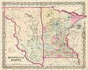
Main Author:
Colton, Joseph Hutchins
Title/Description:
Minnesota and Dakota
Publication Info:
New York: J.H. Colton, 1859
Date:
1859
Scale:
1:2,534,000
Original Source:
Courtesy of
Murray Hudson
, Halls, Tennessee
Viewing options:
JPEG
or
Plugin
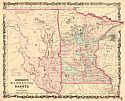
Main Author:
Johnson, Alvin J.
Title/Description:
Johnson's Minnesota and Dakota
Publication Info:
New York: Johnson & Browning, c.1860
Date:
1860
Scale:
1:2,534,000
Original Source:
Courtesy of
Murray Hudson
, Halls, Tennessee
Viewing options:
JPEG
or
Plugin
Main Author:
Johnson, A.J.
Title/Description:
Johnson's Minnesota and Dakota
Publication Info:
New York: Johnson and Ward, 1862; from Johnson's New Illustrated Family Atlas
Date:
1862
Scale:
1:2,534,400
Original Source:
Courtesy of
Murray Hudson
, Halls, Tennessee
Viewing options:
JPEG
or
Plugin
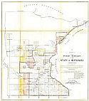
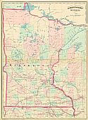
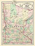
Main Author:
Washburn, W.S.
Title/Description:
(F) Sketch of the Public Surveys in the State of Minnesota
Publication Info:
Washington: Department of the Interior, General Land Office, 1863
Date:
1863
Scale:
1:1,140,000
Original Source:
Courtesy of
Murray Hudson
, Halls, Tennessee
Viewing options:
JPEG
or
Plugin
Main Author:
Johnson, Alvin, J.
Title/Description:
Johnson's Minnessota and Dakota
Publication Info:
New York: Johnson and Ward, 1864
Date:
1864
Scale:
1:2,534,400
Original Source:
Courtesy of
Murray Hudson
, Halls, Tennessee
Viewing options:
JPEG
or
Plugin
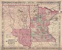
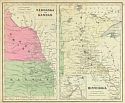
Main Author:
Colton, Joseph H.
Title/Description:
Nebraska and Kansas - Minnesota
Publication Info:
New York: J.H. Colton & Co., c.1865
Date:
1865
Scale:
1:3,624,000
Original Source:
Courtesy of
Murray Hudson
, Halls, Tennessee
Viewing options:
JPEG
or
Plugin
Main Author:
Johnson, A.J.
Title/Description:
Johnson's Minnesota
Publication Info:
New York: A.J. Johnson, c.1865
Date:
1865
Scale:
1:1,584,000
Original Source:
Courtesy of
Murray Hudson
, Halls, Tennessee
Viewing options:
JPEG
or
Plugin
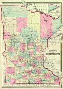
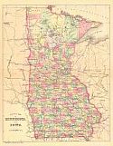
Main Author:
Mitchell, Samuel Augustus
Title/Description:
County Map of the State of Minnesota
Publication Info:
New York: S. Augustus Mitchell, [1866]
Date:
1866
Scale:
1:2,154,000
Original Source:
University of Alabama Map Library
Viewing options:
JPEG
or
Plugin
Main Author:
Colton, G.W.
Title/Description:
Minnesota
Publication Info:
New York: G.W. & C.B. Colton, c.1867
Date:
1867
Scale:
1:1,140,000
Original Source:
Courtesy of
Murray Hudson
, Halls, Tennessee
Viewing options:
JPEG
or
Plugin
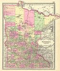
Main Author:
Johnson, A.J.
Title/Description:
Johnson's Minnesota
Publication Info:
New York: A.J. Johnson, 1869
Date:
1869
Scale:
1:1,140,000
Original Source:
Courtesy of
Murray Hudson
, Halls, Tennessee
Viewing options:
JPEG
or
Plugin
Main Author:
Colton, G.W.
Title/Description:
Colton's Minnesota
Publication Info:
New York: G.W. & C.B. Colton, c.1869
Date:
1869
Scale:
1:1,140,000
Original Source:
Courtesy of
Murray Hudson
, Halls, Tennessee
Viewing options:
JPEG
or
Plugin
Main Author:
Asher & Adams
Title/Description:
Asher & Adams' Minnesota
Publication Info:
New York: Asher & Adams, 1872
Date:
1872
Scale:
1:1,267,000
Original Source:
Courtesy of
Murray Hudson
, Halls, Tennessee
Viewing options:
JPEG
or
Plugin
Main Author:
Gray, O.W.
Title/Description:
Gray's Atlas Map of Minnesota
Publication Info:
Philadelphia: O.W. Gray & Son, 1873; from Gray's
Atlas of the United States
Date:
1873
Scale:
1:1,140,000
Original Source:
Courtesy of
Murray Hudson
, Halls, Tennessee
Viewing options:
JPEG
or
Plugin
Main Author:
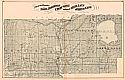
Andreas, A.T.
Title/Description:
Counties of Cottonwood, Murray, Pipestone, Jackson, Nobles, and Rock, Minn.
Publication Info:
A.T. Andreas, 1874
Date:
1874
Scale:
1:190,000
Original Source:
University of Alabama Map Library
Viewing options:
JPEG
or
Plugin
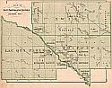
Main Author:
Andreas, Alfred Theodore
Title/Description:
Map of the Counties of Todd, Morrison, Crow Wing, and parts of Mille Lacs, Aitkin and Cass
Publication Info:
Chicago: A.T. Andreas, 1874; from
The Illustrated Historical Atlas of the State of Minnesota
Date:
1874
Scale:
1:220,000
Original Source:
University of Alabama Map Library
Viewing options:
JPEG
or
Plugin
Main Author:
Andreas, Alfred Theodore
Title/Description:
Map of Swift, Chippewa & Lac Qui Parle Counties, Minn.
Publication Info:
Chicago: A.T. Andreas, 1874; from
The Illustrated Historical Atlas of the State of Minnesota
Date:
1874
Scale:
1:220,000
Original Source:
University of Alabama Map Library
Viewing options:
JPEG
or
Plugin
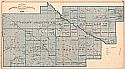
Main Author:
Andreas, Alfred Theodore
Title/Description:
Counties of Renville, Redwood, Yellow Medicine, Lincoln & Lyon, Minn.
Publication Info:
Chicago: A.T. Andreas, 1874; from
The Illustrated Historical Atlas of the State of Minnesota
Date:
1874
Scale:
1:220,000
Original Source:
University of Alabama Map Library
Viewing options:
JPEG
or
Plugin
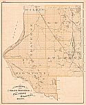
Main Author:
Andreas, Alfred Theodore
Title/Description:
Counties of Grant, Traverse, Big Stone, & Stevens, Minn.
Publication Info:
Chicago: A.T. Andreas, 1874; from
The Illustrated Historical Atlas of the State of Minnesota
Date:
1874
Scale:
1:220,000
Original Source:
University of Alabama Map Library
Viewing options:
JPEG
or
Plugin
Main Author:
Gray, O.W.
Title/Description:
Minnesota
Publication Info:
Philadelphia: O.W. Gray, 1876
Date:
1876
Scale:
1:1,140,000
Original Source:
Courtesy of
Murray Hudson
, Halls, Tennessee
Viewing options:
JPEG
or
Plugin
Main Author:
McNally, Francis
Title/Description:
California. Minnesota
Publication Info:
New York: A.S. Barnes and Company, 1876; from
An Improved System of Geography
Date:
1876
Scale:
1:6,653,000
Original Source:
University of Alabama Map Library
Viewing options:
JPEG
or
Plugin
Main Author:
Roeser, C.
Title/Description:
State of Minnesota
Publication Info:
Washington: U.S. Department of the Interior, General Land Office, 1879
Date:
1879
Scale:
1:1,521,000
Original Source:
Courtesy of
Murray Hudson
, Halls, Tennessee
Viewing options:
JPEG
or
Plugin
Main Author:
Gamble, W.H.
Title/Description:
County Map of Minnesota
Publication Info:
Philadelphia: S.A. Mitchell, Jr., c.1880
Date:
1880
Scale:
1:2,091,000
Original Source:
Courtesy of
Murray Hudson
, Halls, Tennessee
Viewing options:
JPEG
or
Plugin
Main Author:
Colton, G.W. and C.B. Colton
Title/Description:
Minnesota
Publication Info:
Philadelphia: O.W. Gray & Son, 1880; from Gray's
National Atlas
Date:
1880
Scale:
1:1,140,000
Original Source:
Courtesy of
Murray Hudson
, Halls, Tennessee
Viewing options:
JPEG
or
Plugin
Main Author:
Cram, George F.
Title/Description:
Cram's New sectional Map of the State of Minnesota
Publication Info:
St. Paul: The St. Paul Book and Stationary Company, 1880
Date:
1880
Scale:
1:697,000
Original Source:
Courtesy of
Murray Hudson
, Halls, Tennessee
Viewing options:
JPEG
or
Plugin
Main Author:
Bradley, William M.
Title/Description:
County Map of Minnesota and Iowa
Publication Info:
Philadelphia: W.M. Bradley & Co., 1881
Date:
1881
Scale:
1:3,612,000
Original Source:
Courtesy of
Murray Hudson
, Halls, Tennessee
Viewing options:
JPEG
or
Plugin
Main Author:
Rand McNally and Co.
Title/Description:
New Rail Road and County Map of Minnesota
Publication Info:
Chicago: George F. Cram, 1882; from Cram's
Illustrated Family Atlas of the World
Date:
1882
Scale:
1:2,281,000
Original Source:
Courtesy of
Murray Hudson
, Halls, Tennessee
Viewing options:
JPEG
or
Plugin
Main Author:
Tunison, H.C.
Title/Description:
Tunison's Minnesota
Publication Info:
Jacksonville, IL: H.C. Tunison, 1882
Date:
1882
Scale:
1:2,077,000
Original Source:
Courtesy of
Murray Hudson
, Halls, Tennessee
Viewing options:
JPEG
or
Plugin
Main Author:
Cram, George F.
Title/Description:
New Rail Road and County Map of Minnesota
Publication Info:
Chicago: George F. Cram, 1883
Date:
1883
Scale:
1:2,408,000
Original Source:
University of Alabama Map Library
Viewing options:
JPEG
or
Plugin
Main Author:
Hardesty, H.H.
Title/Description:
Map of Minnesota
Publication Info:
New York: H.H. Hardesty & Compay, 1883; from
Hardesty's Historical and Geographical Encyclopedia
Date:
1883
Scale:
1:1,774,000
Original Source:
Courtesy of
Murray Hudson
, Halls, Tennessee
Viewing options:
JPEG
or
Plugin
Main Author:
Title/Description:
Minnesota
Publication Info:
Philadelphia: O.W. Gray and Son, 1883; from
The National Atlas
Date:
1883
Scale:
1:1,140,000
Original Source:
Courtesy of
Murray Hudson
, Halls, Tennessee
Viewing options:
JPEG
or
Plugin
Main Author:
Title/Description:
Minnesota
Publication Info:
Chicago: Rand McNally and Co., 1884; from
Rand McNally Indexed Atlas of the World
Date:
1884
Scale:
1:584,000
Original Source:
From the personal collection of Dr. Gerald Webster
Viewing options:
JPEG
or
Plugin
Main Author:
Hardesty, H.H.
Title/Description:
Map of Minnesota
Publication Info:
Chicago: Rand McNally & Co., 1884
Date:
1884
Scale:
1:1,521,000
Original Source:
Courtesy of
Murray Hudson
, Halls, Tennessee
Viewing options:
JPEG
or
Plugin
Next Page