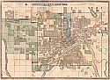
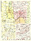
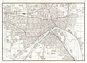
Viewing Options
Main Author:
Curtice, David L.
Title/Description:
St. Paul
Publication Info:
St. Paul: D. L. Curtice, 1886
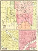
Viewing Options
Main Author:
Rand McNally & Company
Title/Description:
Map of St. Paul, Minneapolis, and Environs & Business Portion of Minneapolis & Business Portion of St. Paul
Publication Info:
Chicago: Rand McNally & Co., 1889; from their Indexed Atlas of the World
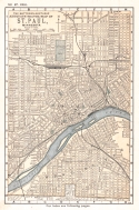
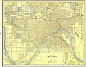
Viewing Options
Main Author:
Matthews-Northrup Company
Title/Description:
St. Paul
Publication Info:
Buffalo: Matthews-Northrup Company, 1893; from The Matthews-Northrup Adequate Travel Atlas of the United States
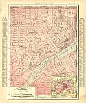
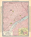
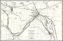
Viewing Options
Main Author:
Rand McNally & Co.
Title/Description:
Map of the Main Portion of St. Paul
Publication Info:
Chicago: Rand McNally & Co., 1895; from Rand McNally's New General Atlas of the World
Viewing Options
Main Author:
Rand McNally and Company
Title/Description:
Map of St. Paul, Minnesota, and Environs and Business Portion of Minneapolis and Business Portion of St. Paul
Publication Info:
Chicago: Rand McNally and Company,1896; from Indexed Atlas of the World
Viewing Options
Main Author:
Cram, George F.
Title/Description:
Map of St. Paul
Publication Info:
Chicago: George F. Cram, 1898; from Cram's Universal Atlas, Geographical, Astronomical and Historical
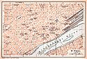
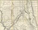
Viewing Options
Main Author:
Rand McNally & Company
Title/Description:
Map of the Main Portion of St. Paul
Publication Info:
Chicago: Rand McNally & Co., 1909
Viewing Options
Main Author:
Baedeker, Karl
Title/Description:
St. Paul
Publication Info:
Leipzig: Karl Baedeker, 1904; from The United States with an Excursion into Mexico

Viewing Options
Main Author:
Rand McNally & Co.
Title/Description:
St. Paul, Minneapolis and Environs & Business Portion of Minneapolis & Business Portion of St. Paul
Publication Info:
Chicago: Rand McNally & Co., 1911
Viewing Options
Main Author:
Cram, George F.
Title/Description:
St. Paul
Publication Info:
Chicago: George F. Cram, 1911; from Cram's Unrivaled Atlas of the World
Viewing Options
Main Author:
Rand McNally and Company
Title/Description:
St. Paul and Vicinity
Publication Info:
Chicago: Rand McNally and Company, 1921; from the Commercial Atlas of America
Viewing Options
Main Author:
Minnesota Geological Survey
Title/Description:
Map of St. Paul showing the rock surface topography
Publication Info:
Minneapolis: Minnesota Geological Survey, 1936; Bulletin 27, Plate 7

