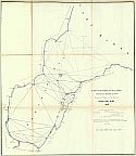
Historical Maps of Other Southeastern States

Selected Michigan Out-of-Print Quadrangles

Next Page

  Main Author:   Young and Delleker
  Title/Description:   Geographical, Statistical, and Historical Map of Michigan Territory
  Publication Info:   Philadelphia: Carey & Lea, 1822; first separte map of Michigan
  Date:   1822
  Scale:   1:1,901,000
  Original Source:   Courtesy of Murray Hudson, Halls, Tennessee
Viewing options:


  Main Author:   Bradford, Thomas Gamaliel
  Title/Description:   Michigan and the Great Lakes
  Publication Info:   Boston: William D. Ticknor and Wiley & Long, 1835; from T.G. Bradfords A Comprehensive Atlas Geographical, Historical, & Commerical
  Date:   1835
  Scale:   1:4,752,000
  Original Source:   Courtesy of Murray Hudson, Halls, Tennessee
Viewing options:


  Main Author:    
  Title/Description:   Sketch of the Public Survey's in the North Part of Michigan
  Publication Info:   Washington, D.C.: General Land Office, 1837; Report to 25th Congress, 2nd Session
  Date:   1837
  Scale:   1:1,140,000
  Original Source:   Courtesy of Murray Hudson, Halls, Tennessee
Viewing options:


  Main Author:   Stone, W.J.
  Title/Description:   No. 2 Michigan
  Publication Info:   Washington, D.C.: General Land Office, 1841
  Date:   1841
  Scale:   1:2,408,000
  Original Source:   Courtesy of Murray Hudson, Halls, Tennessee
Viewing options:


  Main Author:    
  Title/Description:   F-Sketch of the Public Surveys in Michigan
  Publication Info:   [General Land Office, 1845]
  Date:   1845
  Scale:   1:1,140,000
  Original Source:   Courtesy of Murray Hudson, Halls, Tennessee
Viewing options:


  Main Author:    
  Title/Description:   Geological Map of Townships in the Northern Peninsula of Michigan in the Year 1845
  Publication Info:   Baltimore: E. Weber and Co., c.1845
  Date:   1845
  Scale:   1:412,000
  Original Source:   Courtesy of Murray Hudson, Halls, Tennessee
Viewing options:


  Main Author:   Foster, J.W. and J.D. Whitney
  Title/Description:   Geological Map of Keweenaw Point, Lake Superoir, Michigan
  Publication Info:   Philadelphia: P.S. Duval, c.1845
  Date:   1845
  Scale:   1:184,000
  Original Source:   Courtesy of Murray Hudson, Halls, Tennessee
Viewing options:


  Main Author:   Burt, William A. Surveyor
  Title/Description:   Geological Map of Township Lines in the Northern Peninsula of Michigan
  Publication Info:   Washington, DC: Department of the Interior, U.S. Geological Survey, 1845
  Date:   1845
  Scale:   1:445,000
  Original Source:   Courtesy of Murray Hudson, Halls, Tennessee
Viewing options:


  Main Author:   Hubbard & Ives
  Title/Description:   Geological Map of the District Subdivided by Messrs
  Publication Info:   Washington, DC: Department of the Interior, U.S. Geological Survey, 1845
  Date:   1845
  Scale:   1:240,000
  Original Source:   Courtesy of Murray Hudson, Halls, Tennessee
Viewing options:


  Main Author:   Burt, William A.
  Title/Description:   Geological Map of a District of Township Lines in the Northern Peninsula of Michigan
  Publication Info:   Baltimore: E. Weber and Co., 1846
  Date:   1846
  Scale:   1:475,000
  Original Source:   Courtesy of Murray Hudson, Halls, Tennessee
Viewing options:


  Main Author:    
  Title/Description:   Geological Map of the District Subdivided by Messrs Hubbard and Ives
  Publication Info:   Baltimore: E. Weber and Co., c.1846
  Date:   1846
  Scale:   1:234,000
  Original Source:   Courtesy of Murray Hudson, Halls, Tennessee
Viewing options:


  Main Author:   Mitchell, Samuel Augustus
  Title/Description:   A New Map of Michigan with Its Canals, Roads, & Distances
  Publication Info:   Philadelphia: S.A. Mitchell, 1847; from Mitchell's Universal Atlas
  Date:   1847
  Scale:   12,091,000
  Original Source:   Courtesy of Murray Hudson, Halls, Tennessee
Viewing options:


  Main Author:   Foster, J.W. and J.D. Whitney
  Title/Description:   
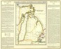
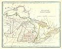
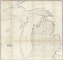
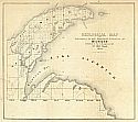
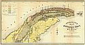
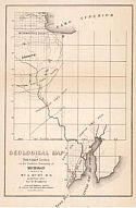
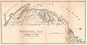
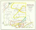
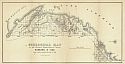
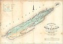
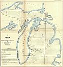
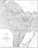
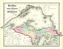
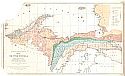
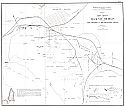
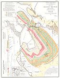
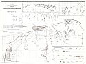
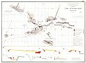
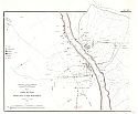
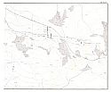
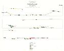
Geological Map of Isle Royale, Lake Superior, Michigan
  Publication Info:   New York: Ackerman Lith., c.1847; Made pursuant to the Act of Congress, approved, March 1st, 1847
  Date:   1847
  Scale:   1:125,000
  Original Source:   Courtesy of Murray Hudson, Halls, Tennessee
Viewing options:


  Main Author:   Foster, J.W. and J.D. Whitney
  Title/Description:   Geological Map of the District Between Portage Lake and Montreal River, Lake Surperior, Michigan
  Publication Info:   Philadelphia: P.S. Duval, c.1849
  Date:   1849
  Scale:   1:209,000
  Original Source:   Courtesy of Murray Hudson, Halls, Tennessee
Viewing options:


  Main Author:   Surveyor General's Office
  Title/Description:   Sketch of the Public Survey in Michigan
  Publication Info:   Detroit: Surveyor General's Office, 1849
  Date:   1849
  Scale:   1:1,140,000
  Original Source:   Courtesy of Murray Hudson, Halls, Tennessee
Viewing options:


  Main Author:   Noble, Charles (Surveyor General)
  Title/Description:   G. Sketch of the Public Surveys in Michigan
  Publication Info:   Detroit: Surveyor General's Office, 1850; from the Surveyor General's Office, November 12th 1850
  Date:   1850
  Scale:   1:1,140,000
  Original Source:   Courtesy of Murray Hudson, Halls, Tennessee
Viewing options:


  Main Author:   Mitchell, Samuel Augustus
  Title/Description:   Michigan and Wisconsin
  Publication Info:   Philadelphia: S.A. Mitchell, 1851
  Date:   1851
  Scale:   1:4,435,000
  Original Source:   Courtesy of Murray Hudson, Halls, Tennessee
Viewing options:


  Main Author:   Young, J.H.
  Title/Description:   No. 15 Map of the States of Michigan & Wisconsin
  Publication Info:   Philadelphia: S.A. Mitchell, 1853; Engraved to Illustrate Mitchell's School and Family Geography
  Date:   1853
  Scale:   1:3,612,000
  Original Source:   Courtesy of Murray Hudson, Halls, Tennessee
Viewing options:


  Main Author:   Surveyor General's Office
  Title/Description:   Sketch of the Public Surveys in Michigan
  Publication Info:   Detroit: Survey General's Office, 1855
  Date:   1855
  Scale:   1:1,140,000
  Original Source:   Courtesy of Murray Hudson, Halls, Tennessee
Viewing options:


  Main Author:   Desilver, Charles
  Title/Description:   A New Map of Michigan with its Canals, Roads, and Distances
  Publication Info:   Philadelphia: Charles Desilver, c. 1856
  Date:   1856
  Scale:   1:2,090,000
  Original Source:   Courtesy of Adams Antiques, Northport, Alabama
Viewing options:


  Main Author:   Colton, Joseph Hutchins
  Title/Description:   Lake Superior and the Northern Port of Michigan
  Publication Info:   New York: J.H. Colton, c.1857
  Date:   1857
  Scale:   1:1,584,000
  Original Source:   Courtesy of Murray Hudson, Halls, Tennessee
Viewing options:


  Main Author:   Baker, S.F.
  Title/Description:   Michigan
  Publication Info:   New Orleans: Morse & Gaston and A.B. Griswold, 1857; from the World In Miniature American
  Date:   1857
  Scale:   1:3,168,000
  Original Source:   Courtesy of Murray Hudson, Halls, Tennessee
Viewing options:


  Main Author:   Meade, George Gordon
  Title/Description:   Survey of the N. and N.W. Lakes Showing the Progress of the Survey in Saginaw Bay, 1857
  Publication Info:   Washington: Surveyor General's Office, c.1857; 35th Congress, 1st Sess. Senate Ex. Doc. No.11
  Date:   1857
  Scale:   1:180,000
  Original Source:   Courtesy of Murray Hudson, Halls, Tennessee
Viewing options:


  Main Author:   Young, J.H.
  Title/Description:   No. 15 Map of the States of Michigan & Wisconsin
  Publication Info:   Philadelphia: S.A. Mitchell, 1858; Engraved to Illustrate Mitchell's School and Family Geography
  Date:   1858
  Scale:   1:3,612,000
  Original Source:   Courtesy of Murray Hudson, Halls, Tennessee
Viewing options:


  Main Author:   Olney, Jesse
  Title/Description:   Map of Michigan, Wisconsin, and Part of Iowa
  Publication Info:   New York: Pratt, Oakley, & Co., 1858; to Illustrate Olney's School Geography
  Date:   1858
  Scale:   1:3,612,000
  Original Source:   Courtesy of Murray Hudson, Halls, Tennessee
Viewing options:


  Main Author:   Mullet, John
  Title/Description:   Plan of Detroit, 1830
  Publication Info:   Philadelphia: c.1860
  Date:   1860
  Scale:   1:3,000
  Original Source:   Courtesy of Murray Hudson, Halls, Tennessee
Viewing options:


  Main Author:   Anon
  Title/Description:   Plan of the Military Reservation at Detroit
  Publication Info:   Washington, D.C.: General Land Office, 1860
  Date:   1860
  Scale:   1:2,400
  Original Source:   Courtesy of Murray Hudson, Halls, Tennessee
Viewing options:


  Main Author:   Brooks, T.B.
  Title/Description:   Map of the Central Portion of the Upper Peninsula, Michigan
  Publication Info:   Geological Survey of Michigan, 1873
  Date:   1873
  Scale:   1:250,000
  Original Source:   Geological Survey of Alabama
Viewing options:


  Main Author:    
  Title/Description:   Sectional Map of Michigan, 1873
  Publication Info:   Chicago: Chapmon & Silas, 1873
  Date:   1873
  Scale:   1:507,000
  Original Source:   Courtesy of Murray Hudson, Halls, Tennessee
Viewing options:


  Main Author:   Colton, Joseph Hutchins
  Title/Description:   Gray's Atlas Map of Michigan No. 1
  Publication Info:   Philadelphia: O.W. Gray, 1873
  Date:   1873
  Scale:   1:1,394,000
  Original Source:   Courtesy of Murray Hudson, Halls, Tennessee
Viewing options:


  Main Author:   Colton, Joseph Hutchins
  Title/Description:   Gray's Atlas Map of Lake Superior and the Northern Part of Michigan No. 2
  Publication Info:   Philadelphia: O.W. Gray, 1873
  Date:  

1873

  Scale:   1:1,584,000
  Original Source:   Courtesy of Murray Hudson, Halls, Tennessee
Viewing options:


  Main Author:   Gray, Ormando W.
  Title/Description:   New Railroad Map of Michigan
  Publication Info:   Philadelphia: O.W. Gray, 1873
  Date:   1873
  Scale:   1:1,267,000
  Original Source:   Courtesy of Murray Hudson, Halls, Tennessee
Viewing options:


  Main Author:   Brooks, T.B.
  Title/Description:   Map of the Upper Peninsula
  Publication Info:   Geological Survey of Michigan, 1873; from Atlas Accompanying Reports on Upper Peninsula, Plate I
  Date:   1873
  Scale:   1:823,680
  Original Source:   University of Alabama Map Library
Viewing options:


  Main Author:   Brooks, T.B.
  Title/Description:   Magneto-Geological Chart of Republic Mountain, Marquette Co., Michigan
  Publication Info:   Geological Survey of Michigan, 1873; from Atlas Accompanying Reports on Upper Peninsula, Plate II
  Date:   1873
  Scale:   1:3,600
  Original Source:   University of Alabama Map Library
Viewing options:


  Main Author:   Brooks, T.B.
  Title/Description:   Map of the Marquette Iron Region Upper Peninsula, Michigan
  Publication Info:   Geological Survey of Michigan, 1873; from Atlas Accompanying Reports on Upper Peninsula, Plate III
  Date:   1873
  Scale:   1:84,480
  Original Source:   University of Alabama Map Library
Viewing options:


  Main Author:   Brooks, T.B.
  Title/Description:   Map of the Menominee Iron Region, Upper Peninsula, Michigan
  Publication Info:   Geological Survey of Michigan, 1873; from Atlas Accompanying Reports on Upper Peninsula, Plate IV
  Date:   1873
  Scale:   1:84,480
  Original Source:   University of Alabama Map Library
Viewing options:


  Main Author:   Brooks, T.B.
  Title/Description:   Map of Iron Mines at Megaunee, Michigan, including The Jackson and the Hematite Mines
  Publication Info:   Geological Survey of Michigan, 1873; from Atlas Accompanying Reports on Upper Peninsula, Plate V
  Date:   1873
  Scale:   1:9,600
  Original Source:   University of Alabama Map Library
Viewing options:


  Main Author:   Brooks, T.B.
  Title/Description:   Map of Republic Mountain and Vicinity, Marquette Co., Michigan
  Publication Info:   Geological Survey of Michigan, 1873; from Atlas Accompanying Reports on Upper Peninsula, Plate VI
  Date:   1873
  Scale:   1:4,800
  Original Source:   University of Alabama Map Library
Viewing options:


  Main Author:   Brooks, T.B.
  Title/Description:   Map of Champion Mine, Marquette Co., Michigan
  Publication Info:   Geological Survey of Michigan, 1873; from Atlas Accompanying Reports on Upper Peninsula, Plate VII
  Date:   1873
  Scale:   1:4,800
  Original Source:   University of Alabama Map Library
Viewing options:


  Main Author:   Brooks, T.B.
  Title/Description:   Map of Washington and Edwards Mines. Humboldt, Marquette Co., Michigan
  Publication Info:   Geological Survey of Michigan, 1873; from Atlas Accompanying Reports on Upper Peninsula, Plate VIII
  Date:   1873
  Scale:   1:4,800
  Original Source:   University of Alabama Map Library
Viewing options:


  Main Author:   Brooks, T.B.
  Title/Description:   Map of Lake Superior Mine. Marquette Co., Michigan
  Publication Info:   Geological Survey of Michigan, 1873; from Atlas Accompanying Reports on Upper Peninsula, Plate IX
  Date:   1873
  Scale:   1:1,200
  Original Source:   University of Alabama Map Library
Viewing options:


  Main Author:   Brooks, T.B.
  Title/Description:   Map of the New York Mine of Marquette Co., Michigan
  Publication Info:   Geological Survey of Michigan, 1873; from Atlas Accompanying Reports on Upper Peninsula, Plate X
  Date:   1873
  Scale:   1:1,200
  Original Source:   University of Alabama Map Library
Viewing options:


  Main Author:   Brooks, T.B.
  Title/Description:   Statistics of the Iron Ore Trade and Iron Ore Mines of the Upper Peninsula
  Publication Info:   Geological Survey of Michigan, 1873; from Atlas Accompanying Reports on Upper Peninsula, Plate IXI
  Date:   1873
  Scale:    
  Original Source:   University of Alabama Map Library
Viewing options:


  Main Author:   Brooks, T.B.
  Title/Description:   Furnaces Consuming L.S. Ores. Production pf Pig Iron. Metallurgical Chemical Character of the Ores
  Publication Info:   Geological Survey of Michigan, 1873; from Atlas Accompanying Reports on Upper Peninsula, Plate XIII
  Date:   1873
  Scale:    
  Original Source:   University of Alabama Map Library
Viewing options:


  Main Author:   Brooks, T.B.
  Title/Description:   Map to Accompany the Cross Section of the Portage Lake District (Part 1)
  Publication Info:   Geological Survey of Michigan, 1873; from Atlas Accompanying Reports on Upper Peninsula, Plate XIVa
  Date:   1873
  Scale:   1:12,000
  Original Source:   University of Alabama Map Library
Viewing options:


  Main Author:   Brooks, T.B.
  Title/Description:   Map to Accompany the Cross Section of the Portage Lake District (Part 2)
  Publication Info:   Geological Survey of Michigan, 1873; from Atlas Accompanying Reports on Upper Peninsula, Plate XIVb
  Date:   1873
  Scale:   1:12,000
  Original Source:   University of Alabama Map Library
Viewing options:


  Main Author:   Brooks, T.B.
  Title/Description:   Cross Sections Near Portage Lake South Shore, No. I
  Publication Info:   Geological Survey of Michigan, 1873; from Atlas Accompanying Reports on Upper Peninsula, Plate XV
  Date:   1873
  Scale:   1:1,080
  Original Source:   University of Alabama Map Library
Viewing options:


  Main Author:   Brooks, T.B.
  Title/Description:   Cross Sections Near Portage Lake South Shore, No. II
  Publication Info:   Geological Survey of Michigan, 1873; from Atlas Accompanying Reports on Upper Peninsula, Plate XVI
  Date:   1873
  Scale:   1:1,080
  Original Source:   University of Alabama Map Library
Viewing options:


  Main Author:   Brooks, T.B.
  Title/Description:   Cross Sections Near Portage Lake South Shore, No. III
  Publication Info:   Geological Survey of Michigan, 1873; from Atlas Accompanying Reports on Upper Peninsula, Plate XVII
  Date:   1873
  Scale:   1:1,080
  Original Source:   University of Alabama Map Library
Viewing options:


  Main Author:   Brooks, T.B.
  Title/Description:   Cross Sections Near Portage Lake South Shore, No. IV
  Publication Info:   Geological Survey of Michigan, 1873; from Atlas Accompanying Reports on Upper Peninsula, Plate XVIII
  Date:   1873
  Scale:   1:1,080
  Original Source:   University of Alabama Map Library
Viewing options:


  Main Author:   Brooks, T.B.
  Title/Description:   Groupded Cross Sections Illustrating Certain Stratigraphical Relations Between Houghton and Keweenaw Counties
  Publication Info:   Geological Survey of Michigan, 1873; from Atlas Accompanying Reports on Upper Peninsula, Plate XIX
  Date:   1873
  Scale:   1:4,800
  Original Source:   University of Alabama Map Library
Viewing options:


  Main Author:   Brooks, T.B.
  Title/Description:   Map to Accompnay the Cross Sections of the Eagle River District
  Publication Info:   Geological Survey of Michigan, 1873; from Atlas Accompanying Reports on Upper Peninsula, Plate XX
  Date:   1873
  Scale:   1:4,800
  Original Source:   University of Alabama Map Library
Viewing options:


  Main Author:   Brooks, T.B.
  Title/Description:   Cross Sections of the Eagle River District, No. I
  Publication Info:   Geological Survey of Michigan, 1873; from Atlas Accompanying Reports on Upper Peninsula, Plate XXI
  Date:   1873
  Scale:   1:1,080
  Original Source:   University of Alabama Map Library
Viewing options:


  Main Author:   Brooks, T.B.
  Title/Description:   Cross Sections of the Eagle River District, No. II
  Publication Info:   Geological Survey of Michigan, 1873; from Atlas Accompanying Reports on Upper Peninsula, Plate XXII
  Date:   1873
  Scale:   1:1,080
  Original Source:   University of Alabama Map Library
Viewing options:


  Main Author:   Brooks, T.B.
  Title/Description:   Geological Section in the Central Mine
  Publication Info:   Geological Survey of Michigan, 1873; from Atlas Accompanying Reports on Upper Peninsula, Plate XXIII
  Date:   1873
  Scale:   1:1,080
  Original Source:   University of Alabama Map Library
Viewing options:
 

Next Page