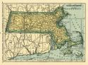
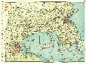
Viewing Options
Main Author:
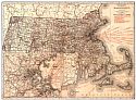
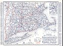
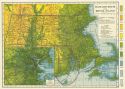
Rand McNally and Company
Title/Description:
Massachusetts
Publication Info:
Chicago: Rand McNally and Company, 1921; from the Commercial Atlas of America
Viewing Options
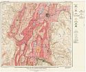
Main Author:
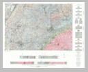
U.S. Geological Survey
Title/Description:
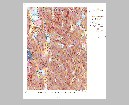
Map of Sheffield Quadrangle and Part of Sandfield Quadrangle, New York, Massachusetts and Connecticut, Showing areas of Calcitic and Dolomitic Limestones
Publication Info:
Washington: Department of the Interior, U.S. Geological Survey, 1923; Bulletin 744 Plate 3
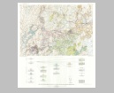
Viewing Options
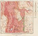
Main Author:
U.S. Geological Survey
Title/Description:
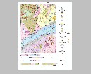
Map of Parts of Greylock, Berlin and Hoosick Quadrangles New York, Massachusetts, and Vermont, Showing Areas of Calcite and Colomitic Limestone
Publication Info:
Washington: Department of the Interior, U.S. Geological Survey, 1923; Bulletin 744 Plate 1
Viewing Options
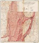
Main Author:
U.S. Geological Survey
Title/Description:
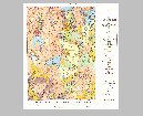
Map of Pittsfield Quadrangle and Part of Becket Quadrangle, Massachusetts and New York, Showing areas of Calcitic and Dolomitic Limestones
Publication Info:
Washington: Department of the Interior, U.S. Geological Survey, 1923; Bulletin 744 Plate 2
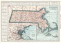
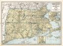
Viewing Options
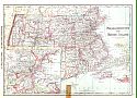
Main Author:
Funk and Wagnalls Company
Title/Description:
Massachusetts
Publication Info:
New York: Funk and Wagnalls Company, 1923; from Atlas of the World and Gazetteer
Viewing Options
Main Author:
U.S. Geological Survey
Title/Description:
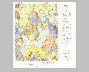
Map showing Quaternary Geology of the Ware and Quinsigamond Quadrangles, Massachusetts
Publication Info:
Washington: Department of the Interior, U.S. Geological Survey, 1924; Bulletin 760 Plate 6
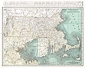
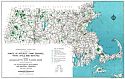
Viewing Options
Main Author:
Reynolds, Francis J.
Title/Description:
Massachusetts, Boston and Vicinity
Publication Info:
New York: P.F. Collier and Son Company, 1924; from The New World Atlas and Gazetteer
Viewing Options
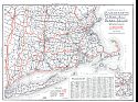
Main Author:
Rand McNally and Company
Title/Description:
Massachusetts
Publication Info:
Chicago: Rand McNally and Company, 1925; from Premier Atlas of the World
Viewing Options
Main Author:
Clason Map Company
Title/Description:
Best Roads of Massachusetts, Connecticut, and Rhode Island
Publication Info:
Chicago: Clason Map Company, c. 1927; from Clason's Touring Atlas
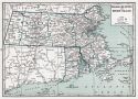
Viewing Options
Main Author:
National Map Company
Title/Description:
Massachusetts and Rhode Island
Publication Info:
Indianapolis: National Map Company, 1930; from Official Paved Road and Commercial Survey of the United States
Viewing Options
Main Author:
Clason Map Company
Title/Description:
Clason's Road Map of Massachusetts, Connecticut, and Rhode Island
Publication Info:
Denver: The Clason Map Company, 1930; from Clason's Touring Atlas of the United States and Canada
Viewing Options
Main Author:
C.S. Hammond and Company
Title/Description:
Massachusetts, Connecticut and Rhode Island
Publication Info:
New York: C.S. Hammond and Company, c. 1930; from The New World Loose Leaf Atlas, Sixth Edition
Viewing Options
Main Author:
C.S. Hammond and Company
Title/Description:
Massachusetts
Publication Info:
New York: C.S. Hammond and Company, c. 1930; from The New World Loose Leaf Atlas, Sixth Edition
Viewing Options
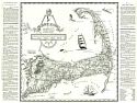
Main Author:
Morang, Kenneth E.
Title/Description:
Cape Cod
Publication Info:
Cape Cop: Cape Cod Chamber of Commerce, 1934
Viewing Options
Main Author:
Gulf Refining Company
Title/Description:
1935 Official Road Map, Massachusetts, Connecticut and Rhode Island
Publication Info:
Chicago: Rand McNally and Company, 1935
Original Source:
Murray Hudson
Viewing Options
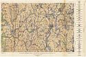
Main Author:
Branom, Frederick K. and Lloyd Edwin Smith
Title/Description:
Massachusetts and Rhode Island
Publication Info:
Chicago: Geographical Publishing Company, 1936; from Capper's 1936 Atlas of the World
Viewing Options
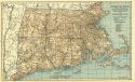
Main Author:
Rand McNally and Company
Title/Description:
Standard Map of Massachusetts
Publication Info:
Chicago: Rand McNally and Company, 1936
Viewing Options
Main Author:
Geographical Publishing Company
Title/Description:
Massachusetts, Rhode Island, and Connecticut
Publication Info:
Chicago: Geographical Publishing Company, 1942; from The New International Atlas of the World, War Edition
Viewing Options
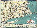
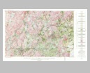
Main Author:
The Massachusetts Development and Industrial Commission
Title/Description:
Massachusetts Tourists Map Showing Points of Interest, Camp Grounds, Picnic Sites and Beaches
Publication Info:
Boston: The Massachusetts Development and Industrial Commission, 1946
Viewing Options
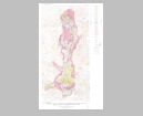
Main Author:
U.S. Geological Survey
Title/Description:
Melt-Water Drainage Sequence Diagram of the Hudson and Maynard Quadrangles, Massachusetts
Publication Info:
Washington: Department of the Interior, U.S. Geological Survey, 1956; Bulletin 1038 Plate 3
Viewing Options
Main Author:
U.S. Geological Survey
Title/Description:
Map and Sections Showing Bedrock Geology of the Hudson and Maynard Quadrangles, Massachusetts
Publication Info:
Washington: Department of the Interior, U.S. Geological Survey, 1956; Bulletin 1038 Plate 1
Viewing Options
Main Author:
U.S. Geological Survey
Title/Description:
Map Showing Surficial Geology of the Hudson and Maynard Quadrangles, Massachusetts
Publication Info:
Washington: Department of the Interior, U.S. Geological Survey, 1956; Bulletin 1038 Plate 2
Viewing Options
Main Author:
U.S. Geological Survey
Title/Description:
Surficial Geologic Map of the Mystic Lokes-Fresh Pond Buried Valley Area Between Wilmington and Cambridge Massachusetts
Publication Info:
Washington: Department of the Interior, U.S. Geological Survey, 1959; Bulletin 1061-F Plate 4
Viewing Options
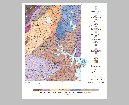
Main Author:
U.S. Geological Survey
Title/Description:
Bedrock Geology of the Salem Quadrangle and Vicinity, Massachusetts
Publication Info:
Washington: Department of the Interior, U.S. Geological Survey, 1964; Bulletin 1163-A Plate 1
Viewing Options
Main Author:
U.S. Geological Survey
Title/Description:
Surficial Geologic Map of the Athol Quadrangle, Massachusetts
Publication Info:
Washington: Department of the Interior, U.S. Geological Survey, 1966; Bulletin 1163-C Plate 1
Viewing Options
Main Author:
U.S. Geological Survey
Title/Description:
Bedrock Geologic Map and Sections of the Norwood Quadrangle, Massachusetts
Publication Info:
Washington: Department of the Interior, U.S. Geological Survey, 1966; Bulletin 1163-B Plate 1
Viewing Options
Main Author:
U.S. Geological Survey
Title/Description:
Surficial Geologic Map of the Norwood Quadrangle, Massachusetts
Publication Info:
Washington: Department of the Interior, U.S. Geological Survey, 1966; Bulletin 1163-B Plate 2
Viewing Options
Main Author:
U.S. Geological Survey
Title/Description:
Geologic Map of the Taunton Quadrangle, Bristol and Plymouth Counties, Massachusetts
Publication Info:
Washington: Department of the Interior, U.S. Geological Survey, 1967; Bulletin 1163-D Plate 1

