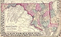
1875 - 1900
Before 1875
1875-1900
1901-1910
1911-1925
After 1925

Previous Page
Next Page

  Main Author:   Mitchell, Samuel A.  
  Title/Description:   County Map of Maryland and Delaware
  Publication Info:   Philadelphia: S. Augustus Mitchell, 1876
  Date:   1876
  Scale:   1:1,450,000
  Original Source:   Birmingham Public Library Cartography Collection
Viewing options:


  Main Author:   Gray, Ormando W.
  Title/Description:   Gray's New Map of Baltimore
  Publication Info:   Philadelphia: O.W. Gray and Son, 1876
  Date:   1876
  Scale:   1:25,740
  Original Source:   Courtesy of Murray Hudson, Halls, Tennessee
Viewing options:


  Main Author:   Godfrey, Jaeger and Company
  Title/Description:   Map of Maryland, Delaware, and the District of Columbia
  Publication Info:   Godfrey, Jaeger and Company, 1881; from The Historic Hand Atlas of 1881.
  Date:   1881
  Scale:   1:1,140,000
  Original Source:   University of Alabama Map Library
Viewing options:


  Main Author:   Swinton, William
  Title/Description:   Maryland and Delaware
  Publication Info:   New York: Ivision, Blakeman, Taylor and Company, 1881; from Swinton's Grammer School Geography
  Date:   1881
  Scale:   1:887,040
  Original Source:   Courtesy of Murray Hudson, Halls, Tennessee
Viewing options:


  Main Author:   Gray, Ormando W.
  Title/Description:   Maryland, Delaware and the District of Columbia
  Publication Info:   Philadelphia: O.W. Gray and Son, 1883; from The National Atlas
  Date:   1883
  Scale:   1:633,600
  Original Source:   Courtesy of Murray Hudson, Halls, Tennessee
Viewing options:


  Main Author:   Rand McNally and Company
  Title/Description:   Maryland & Delaware
  Publication Info:   Chicago: Rand McNally and Company, 1884; from The Indexed Atlas of the World
  Date:   1884
  Scale:   1:76,000
  Original Source:   From the personal collection of Dr. Gerald Webster
Viewing options:


  Main Author:   Rand McNally and Company
  Title/Description:   Maryland
  Publication Info:   Chicago: Rand McNally and Company, 1885; from The Standard Atlas of the World
  Date:   1885
  Scale:   1:2,030,070
  Original Source:   Courtesy of Murray Hudson, Halls, Tennessee
Viewing options:


  Main Author:   Cram, George F.
  Title/Description:   Maryland and Delaware
  Publication Info:   Chicago: George F. Cram, 1887
  Date:   1887
  Scale:   1:1,267,000
  Original Source:   Courtesy of Murray Hudson, Halls, Tennessee
Viewing options:


  Main Author:   Johnson, A.J.
  Title/Description:   Map of Maryland and Delaware
  Publication Info:   New York: A.J. Johnson, c.1888; from Cyclopedia
  Date:   1888
  Scale:   1:1,901,000
  Original Source:   Courtesy of Murray Hudson, Halls, Tennessee
Viewing options:


  Main Author:   Rand McNally and Company
  Title/Description:   Maryland and Delaware
  Publication Info:   Chicago: Rand McNally and Company, 1888; from The Standard Atlas of the World
  Date:   1888
  Scale:   1:1,124,400
  Original Source:   University of Alabama Map Library
Viewing options:


  Main Author:   Cram, George F.
  Title/Description:   Maryland and Delaware
  Publication Info:   Chicago: George F. Cram, 1888; from The Standard American Atlas
  Date:   1888
  Scale:   1:760,320
  Original Source:   Courtesy of Murray Hudson, Halls, Tennessee
Viewing options:


  Main Author:   Peoples Publishing Company
  Title/Description:   Maryland and Delaware
  Publication Info:   Chicago: Peoples Publishing Company, 1889; from The Peoples Family Atlas of the World
  Date:   1889
  Scale:   1:1,267,000
  Original Source:   University of Alabama Map Library
Viewing options:


  Main Author:   Rand McNally and Company
  Title/Description:   Maryland
  Publication Info:   Chicago: Rand McNally and Company, 1889; from The Enlarged Business Atlas and Shippers Guide
  Date:   1889
  Scale:   1:728,640
  Original Source:   Courtesy of Murray Hudson, Halls, Tennessee
Viewing options:


  Main Author:   Rand McNally and Company
  Title/Description:   Maryland and Delaware
  Publication Info:   Chicago: Rand McNally and Company, 1890; from The Family Atlas of the World
  Date:   1890
  Scale:   1:1,140,480
  Original Source:   University of Alabama Map Library
Viewing options:


  Main Author:    
  Title/Description:   Bristol Bar, Patuxent River, Maryland
  Publication Info:   Washington: Government Printing Office,1890; from The Annual Report of the Secretary of War to 51st Congress, 2nd Session, Ex. Doc. 1, Part 2
  Date:   1890
  Scale:   1:3,240
  Original Source:   Courtesy of Murray Hudson, Halls, Tennessee
Viewing options:


  Main Author:    
  Title/Description:   Index Map, Potomac River from Washington to Chesapeake Bay
  Publication Info:   Washington: Government Printing Office,1890; from The Annual Report of the Secretary of War to 51st Congress, 2nd Session, Ex. Doc. 1, Part 2
  Date:   1890
  Scale:   1:412,000
  Original Source:   Courtesy of Murray Hudson, Halls, Tennessee
Viewing options:


  Main Author:   Cram, George F.
  Title/Description:   Maryland and Delaware
  Publication Info:   Rochester: W.H. Stewart, c. 1890; from Cram's Unrivaled Atlas of the World
  Date:   1890
  Scale:   1:1,267,200
  Original Source:   Courtesy of Murray Hudson, Halls, Tennessee
Viewing options:


  Main Author:   Mast, Crowell and Kirkpatrick
  Title/Description:   Maryland, Delaware, etc.
  Publication Info:   Philadelphia: Mast, Crowell and Kirkpatrick, 1892; from The Popular Atlas of the World
  Date:   1892
  Scale:   1:1,393,920
  Original Source:   Courtesy of Murray Hudson, Halls, Tennessee
Viewing options:


  Main Author:   Rand McNally and Company
  Title/Description:   Maryland, Delaware, and DC
  Publication Info:   Chicago: Rand McNally and Company, 1893; from The Universal Atlas of the World
  Date:   1893
  Scale:   1:1,630,200
  Original Source:   University of Alabama Map Library
Viewing options:


  Main Author:   Cram, George F.
  Title/Description:   Maryland and Delaware
  Publication Info:   Chicago: Henry S. Stebbing, 1883; from Cram's Unrivaled Family Atlas of the World
  Date:   1883
  Scale:   1:1,267,200
  Original Source:   Courtesy of Murray Hudson, Halls, Tennessee
Viewing options:


  Main Author:   Rand McNally and Company
  Title/Description:   Maryland and Delaware
  Publication Info:   Chicago: Rand McNally and Company 1895; from The New General Atlas of the World
  Date:   1895
  Scale:   1:950,000
  Original Source:   Courtesy of Murray Hudson, Halls, Tennessee
Viewing options:


  Main Author:   Walker, H.B.
  Title/Description:   Maryland and Delaware
  Publication Info:   Chicago: H.B. Walker, 1895; from The International Atlas
  Date:   1895
  Scale:   1:760,320
  Original Source:   Courtesy of Murray Hudson, Halls, Tennessee
Viewing options:


  Main Author:   Smith, H.S.
  Title/Description:   Maryland, Delaware, etc.
  Publication Info:   Philadelphia: Historical Publishing Company, 1896; from The Historical Atlas
  Date:   1896
  Scale:   1:1,393,920
  Original Source:  

University of Alabama Map Library

Viewing options:


  Main Author:   Maryland Geological Survey
  Title/Description:   A Hypsometric Map of Maryland
  Publication Info:   Baltimore: Maryland Geological Survey, 1897
  Date:   1897
  Scale:   1:1,000,000
  Original Source:   Geological Survey of Alabama
Viewing options:


  Main Author:   Maryland Geological Survey
  Title/Description:   A Geological Map of Maryland
  Publication Info:   Baltimore: Maryland Geological Survey, 1897
  Date:   1897
  Scale:   1:1,000,000
  Original Source:   Geological Survey of Alabama
Viewing options:


  Main Author:   Cram, George F.
  Title/Description:   Maryland & Delaware
  Publication Info:   Chicago: George F. Cram, 1898; from The Universal Atlas, Geographical, Astronomical and Historical
  Date:   1898
  Scale:   1:1,267,000
  Original Source:   Courtesy of Adams Antiques, Northport, Alabama
Viewing options:


  Main Author:   Funk and Wagnalls Company
  Title/Description:   Maryland and Delaware
  Publication Info:   New York: Funk and Wagnalls Company, 1898; from A Standard Atlas of the World
  Date:   1898
  Scale:   1:1,267,000
  Original Source:   University of Alabama Map Library
Viewing options:


  Main Author:   Mast, Crowell and Kirkpatrick
  Title/Description:   Map of Maryland and Delaware
  Publication Info:   Philadelphia: Mast, Crowell and Kirkpatrick, 1898; from The Peerless Atlas of the World
  Date:   1898
  Scale:   1:1,330,560
  Original Source:   University of Alabama Map Library
Viewing options:


  Main Author:   Cram, George F.
  Title/Description:   Maryland and Delaware
  Publication Info:   Chicago: George F. Cram, 1899; from The Standard American Railway Atlas
  Date:   1899
  Scale:   1:760,000
  Original Source:   University of Alabama Map Library
Viewing options:


  Main Author:   Smith, Benjamin E.
  Title/Description:   Maryland, Delaware, and the District of Columbia
  Publication Info:   New York: The Century Company, 1899; from The Century Atlas of the World
  Date:   1899
  Scale:   1:1,013,760
  Original Source:   University of Alabama Map Library
Viewing options:


Main Author:   Maryland Geological Survey
Title/Description:   Map of Allegany County Showing the Topography and Election Districts
Publication Info:   Baltimore: Maryland Geological Survey, 1900; from The Physical Atlas of Maryland
Date:   1900
Scale:   1:62,500
Original Source:   University of Alabama Map Library
West Sheet
Cental Sheet
East Sheet
Viewing options:
Viewing options:
Viewing options:
JPEG or Plugin
JPEG or Plugin
JPEG or Plugin


Main Author:   Maryland Geological Survey
Title/Description:   Map of Allegany County Showing the Geological Formations and Agriculture Soils
Publication Info:   Baltimore: Maryland Geological Survey, 1900; from The Physical Atlas of Maryland
Date:   1900
Scale:   1:62,500
Original Source:   University of Alabama Map Library
West Sheet
Cental Sheet
East Sheet
Viewing options:
Viewing options:
Viewing options:
JPEG or Plugin
JPEG or Plugin
JPEG or Plugin


  Main Author:   Rand McNally and Company.
  Title/Description:   Maryland, D.C. and Delaware Railroads
  Publication Info:   Chicago: Rand McNally and Company, 1900; from The Enlarged Business Atlas and Shipper's Guide
  Date:   1900
  Scale:   1:696,960
  Original Source:   Courtesy of Murray Hudson, Halls, Tennessee
Viewing options:
 

Previous Page
Next Page